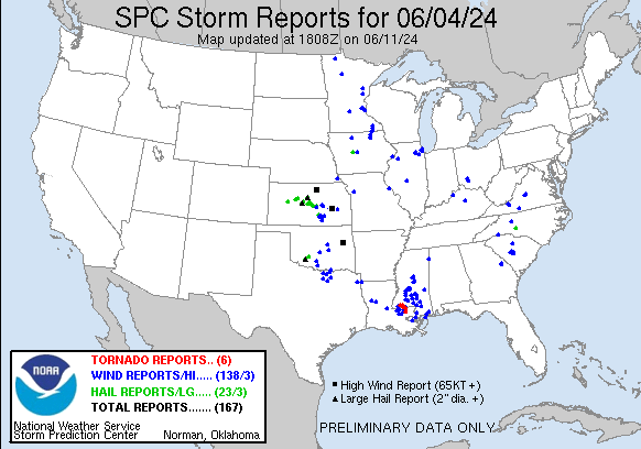
| Tornado Reports (CSV) (Raw Tornado CSV)(?) |
|---|
Time | | Location | County | State | Lat | Lon | Comments |
| 2136 | | 4 WNW Liberty | Amite | MS | 3118 | 9087 | An EF-1 tornado embedded in a QLCS formed along Enterprise Rd west of Liberty were a large pine tree was snapped. This tornado then moved eastward towards Toler Ln wher (LIX) |
| 2148 | | 3 ENE Liberty | Amite | MS | 3117 | 9075 | This EF-1 tornado embedded in a QLCS formed along Highway 24 east of Liberty. Here ... large limbs were broken off an oak tree. The tornado moved to the east-southeast t (LIX) |
| 2155 | | 2 WSW Gillsberg | Amite | MS | 3101 | 9069 | An EF-1 tornado embedded in a QLCS started just north of the Louisiana/Mississippi State line in Gillsburg. It uprooted and snapped hardwoods along Travis Rd and Highwa (LIX) |
| 2204 | | 4 WNW Osyka | Pike | MS | 3102 | 9054 | Continuation of Gillburg tornado into Pike County and the city of Osyka. (LIX) |
| 2208 | | 3 E Kentwood | Tangipahoa | LA | 3094 | 9047 | This EF-1 tornado touched down just east of Kentwood north of Highway 38 where a snapped pine tree was observed. The tornado continued over mostly open fields until Hig (LIX) |
| 2209 | | 2 W Amite | Tangipahoa | LA | 3073 | 9055 | Parish officials passed on multiple reports of a possible tornado between LA 1045 and 1046 just west of Amite. CC drop also noticed on radar. Still waiting on details. (LIX) |
| Hail Reports (CSV) (Raw Hail CSV)(?) |
|---|
Time | Size | Location | County | State | Lat | Lon | Comments |
| 1557 | 125 | 4 E Pendennis | Lane | KS | 3864 | 10027 | (DDC) |
| 1647 | 125 | 9 ESE Cedar Bluff | Ellis | KS | 3879 | 9957 | (DDC) |
| 1718 | 100 | 1 W Hays | Ellis | KS | 3887 | 9934 | Report from mPING: Quarter (1.00 in.). (DDC) |
| 1718 | 100 | 2 WNW Hays | Ellis | KS | 3890 | 9936 | (DDC) |
| 1805 | 250 | 1 SE Galatia | Barton | KS | 3862 | 9894 | KAKE relayed a picture of tennis ball sized hail. Time is estimated from radar. (ICT) |
| 1820 | 175 | 4 E Galatia | Barton | KS | 3864 | 9889 | Mostly smaller pea sized hail but a few golf ball sized hail pieces. (ICT) |
| 1843 | 125 | 4 SSE Lucas | Russell | KS | 3900 | 9852 | Quarter to half dollar sized hail. Time is estimated from radar. (ICT) |
| 1900 | 200 | 6 WSW Sylvan Grove | Russell | KS | 3897 | 9849 | Army Corps of Engineers had mainly nickel to quarter sized with a few larger than golf balls. Time is estimated. (ICT) |
| 1907 | 100 | Mount Pleasant | Cabarrus | NC | 3540 | 8043 | A retired fire department employee reported mostly pea sized hail with a few hail stones quarter sized. The storm started with near 40mph gusts then decreased to 15 to (GSP) |
| 1948 | 150 | 3 E Claflin | Barton | KS | 3852 | 9848 | Spotter reported quarter to ping-pong ball sized hail. (ICT) |
| 1950 | 100 | Holyrood | Ellsworth | KS | 3858 | 9841 | (ICT) |
| 2002 | 150 | Lorraine | Ellsworth | KS | 3857 | 9831 | Picture relayed via social media from KWCH. (ICT) |
| 2017 | 100 | 3 WNW Geneseo | Ellsworth | KS | 3854 | 9820 | (ICT) |
| 2026 | 175 | 1 NE Frederick | Rice | KS | 3852 | 9826 | (ICT) |
| 2124 | 150 | Little River | Rice | KS | 3840 | 9801 | Picture on social media relayed via KWCH. (ICT) |
| 2206 | 150 | 4 SW Mcpherson | McPherson | KS | 3833 | 9771 | Along Highway 61. Courtesy of KAKE TV. (ICT) |
| 2208 | 100 | Mcpherson | McPherson | KS | 3837 | 9766 | (ICT) |
| 2209 | 100 | Mcpherson | McPherson | KS | 3837 | 9766 | Report from mPING: Quarter (1.00 in.). (ICT) |
| 2212 | 175 | Mcpherson | McPherson | KS | 3837 | 9766 | Report came in via social media. (ICT) |
| 2248 | 100 | 2 E Dana | Greene | IA | 4211 | 9420 | Via Raccoon Valley Radio. Time estimated from radar. (DMX) |
| 0020 | 125 | Maize | Sedgwick | KS | 3777 | 9747 | Delayed report from KWCH media. (ICT) |
| 0313 | 125 | 3 S Lake Ellsworth | Comanche | OK | 3479 | 9835 | Report from mPING: Half Dollar (1.25 in.). (OUN) |
| 0330 | 275 | Cache | Comanche | OK | 3463 | 9863 | (OUN) |
| Wind Reports (CSV) (Raw Wind CSV)(?) |
|---|
Time | Speed | Location | County | State | Lat | Lon | Comments |
| 1723 | UNK | 3 SSE Westport | Oldham | KY | 3845 | 8545 | Report of limps down that snapped power pole along highway 42 near Greenhaven Lane. via NWS Chat. (LMK) |
| 1813 | UNK | 2 N Red Bank | Lexington | SC | 3395 | 8123 | Reported power line down in the roadway near Two Notch Road and S. Lake Drive. (CAE) |
| 1839 | UNK | Wilton | Beltrami | MN | 4755 | 9501 | Mature tree damage and downed power lines. (FGF) |
| 1845 | UNK | 1 ESE Provencal | Natchitoches | LA | 3164 | 9318 | A large tree was downed at the 3000 block of North Blvd in Provencal. (SHV) |
| 1848 | UNK | 3 ESE Wannaska | Roseau | MN | 4865 | 9568 | A few small tree branches down. Power lines down. Also reported dime sized hail. (FGF) |
| 1911 | UNK | 9 S Montgomery | Natchitoches | LA | 3153 | 9289 | A tree was blown down across Coco Bed Road in the Cloutierville community. (SHV) |
| 1918 | UNK | 6 NNW Pelion | Lexington | SC | 3385 | 8129 | SC Dept of Public Safety reported a tree down along Platt Springs Road. Time estimated by radar. (CAE) |
| 1927 | UNK | 1 NE Swansea | Lexington | SC | 3374 | 8109 | Reported a tree down across the roadway at Huckabee Mill Road near the Town of Swansea. (CAE) |
| 1929 | UNK | 2 N Swansea | Lexington | SC | 3376 | 8111 | Reported tree down blocking Happy Town Road near the Town of Swansea. (CAE) |
| 1936 | UNK | 8 ESE Mill Spring | Polk | NC | 3524 | 8203 | A couple of trees were blown down in the Green Creek area. (GSP) |
| 1948 | UNK | 3 SW Sandy Run | Lexington | SC | 3377 | 8101 | Reported a tree on a powerline along Farm Road. (CAE) |
| 1953 | 77 | 2 SSE Concordia | Cloud | KS | 3955 | 9765 | KCNK. (TOP) |
| 2000 | UNK | 4 SSE Concordia | Cloud | KS | 3952 | 9763 | Power lines down. (TOP) |
| 2001 | UNK | 5 SSE Concordia | Cloud | KS | 3951 | 9763 | Report of roof damage and tin sheds destroyed at 160th and Noble Roads. (TOP) |
| 2039 | UNK | 7 N Hutchinson | Meeker | MN | 4499 | 9437 | *** 1 INJ *** Corrects previous tstm wnd dmg report from 7 N Hutchinson. Relayed report from sheriffs office of a shed with roof blown off and sides collapsed. (MPX) |
| 2044 | UNK | 6 WSW Lake Wateree SP | Fairfield | SC | 3440 | 8096 | Reported a tree down on a power line along Hope Road near Old River Road. (CAE) |
| 2045 | UNK | 1 ENE Mansura | Avoyelles | LA | 3106 | 9204 | Tree down on car at Highway 1 in Mansura. No injury. (LCH) |
| 2055 | UNK | 6 SSE Lexington | Fayette | KY | 3797 | 8445 | Via WKYT ... social media post of large tree limbs around 1300-1400 Delong Rd. (LMK) |
| 2057 | UNK | 1 NE Figsboro | Henry | VA | 3679 | 7983 | Tree down blocking the roadway. (RNK) |
| 2106 | 60 | 2 SSE Davenport Municip | Scott | IA | 4160 | 9057 | (DVN) |
| 2108 | UNK | Mount Joy | Scott | IA | 4161 | 9055 | 2 to 3 inch wide branches down at this location. Employee estimated 60 MPH winds one mile southeast of location at 407 PM. (DVN) |
| 2119 | UNK | 7 N Hutchinson | Meeker | MN | 4499 | 9437 | *** 1 INJ *** Relayed report from sheriffs office of a shed with roof blown off and sides collapsed. (MPX) |
| 2120 | UNK | 1 E Jackson | East Feliciana | LA | 3083 | 9119 | Widespread tree and powerline damage reported by the parish. More details still to come. (LIX) |
| 2125 | 63 | 2 W Algona | Kossuth | IA | 4308 | 9427 | (DMX) |
| 2127 | UNK | 4 S Parrott | Pulaski | VA | 3716 | 8064 | Tree and wires down on Highland Road. (RNK) |
| 2128 | UNK | Centreville | Wilkinson | MS | 3109 | 9107 | Corrects previous tstm wnd dmg report from Centreville. Widespread trees damage. Many uprooted and/or snapped in Centreville. (LIX) |
| 2130 | UNK | 3 SSE Poplar Hill | Pulaski | VA | 3718 | 8071 | One tree down near Cleburne Boulevard and Old Cloyd Road. (RNK) |
| 2130 | UNK | 2 WNW Amherst | Amherst | VA | 3760 | 7908 | Tree down on Kenmore Road. (RNK) |
| 2132 | UNK | 1 N Clinton | East Feliciana | LA | 3087 | 9102 | Widespread tree and powerline damage across the area. Further details will be sent later. (LIX) |
| 2143 | UNK | 5 NNW Terry | Hinds | MS | 3217 | 9034 | Tree down at the intersection of Flowers Rd & Kimbell Rd. (JAN) |
| 2145 | UNK | 3 WSW Jackson | Hinds | MS | 3228 | 9022 | A tree fell on a home on Will O Wisp Way ... resulting in a house fire. (JAN) |
| 2145 | UNK | 2 S Automba | Carlton | MN | 4649 | 9302 | Report of a huge and healthy ... but old ... maple tree that snapped over a powerline 0.5 miles SW of this location ... and a 2 ft in diameter pine that had fallen over CR (DLH) |
| 2146 | UNK | Circle Pines | Anoka | MN | 4515 | 9316 | 3 inch diameter branches blown off trees and smaller. (Mostly soft wood) One power line came down off one pole and fell on another power line (multiple flashes and spar (MPX) |
| 2148 | UNK | 3 SW Greenwell Spring | East Baton Rouge | LA | 3055 | 9104 | Large Oak tree snapped on Lazy Lake Dr. (LIX) |
| 2148 | UNK | 1 SE Monterey | Rankin | MS | 3218 | 9006 | Numerous trees down all along Thomasville Rd. (JAN) |
| 2150 | UNK | 1 WNW New Glasgow | Amherst | VA | 3764 | 7900 | Tree down on Fletchers Level Road. (RNK) |
| 2151 | UNK | 1 NNW Circle Pines | Anoka | MN | 4516 | 9316 | Photo sent via Facebook of 2 large trees blocking the road. (MPX) |
| 2154 | UNK | Hazlehurst | Copiah | MS | 3186 | 9040 | Sporadic trees reported down across Copiah County. (JAN) |
| 2154 | 69 | 3 WSW Nemaha | Nemaha | NE | 4031 | 9573 | Personal Weather Station. (OAX) |
| 2155 | UNK | 3 ENE Watson | Livingston | LA | 3059 | 9091 | Powerlines down on Cheray Dr. Relayed via Social Media. (LIX) |
| 2155 | UNK | 2 N Atkinson | Henry | IL | 4145 | 9001 | Tree downed. Time estimated using radar. (DVN) |
| 2155 | UNK | 1 NNW Circle Pines | Anoka | MN | 4516 | 9316 | 14 inch diameter tree down ... signs down at Lexington Ave and Pheasant Ridge Dr. (MPX) |
| 2156 | UNK | 3 W Brandon | Rankin | MS | 3228 | 9004 | Stop lights blown down along Hwy 18 at the overpass of Interstate 20. (JAN) |
| 2157 | 72 | 3 WNW Brandon | Rankin | MS | 3228 | 9003 | Measured with portable anemometer. (JAN) |
| 2158 | UNK | 2 NW Brandon | Rankin | MS | 3230 | 9001 | A tree was blown down into power lines behind Sunline Drive. Branches were also blown down in the area. (JAN) |
| 2159 | UNK | Greensburg | St. Helena | LA | 3083 | 9067 | Widespread tree damage across the area. (LIX) |
| 2200 | 65 | 5 NNE Inman | McPherson | KS | 3829 | 9774 | KAKE meteorologist reports stronger than 60 mph winds. (ICT) |
| 2203 | UNK | 3 N Montpelier | St. Helena | LA | 3072 | 9065 | Multiple trees down are southeastern St Helena parish. (LIX) |
| 2205 | UNK | 1 NE Kentwood | Tangipahoa | LA | 3094 | 9051 | Multiple trees down around Kentwood. (LIX) |
| 2208 | UNK | Kentwood | Tangipahoa | LA | 3094 | 9051 | Widespread trees down across the parish reported be EM. More details expected later. (LIX) |
| 2209 | UNK | Brookhaven | Lincoln | MS | 3158 | 9044 | 10-15 trees reported down within the city limits of Brookhaven. (JAN) |
| 2210 | UNK | 1 SE Crystal Springs | Copiah | MS | 3198 | 9035 | Large wooden light pole pushed over at a ballfield near the Mississippi Job Corps Center. (JAN) |
| 2210 | UNK | Circle Pines | Anoka | MN | 4515 | 9316 | Found on a public Facebook page. Report of a tree through a house. Other reports of trees down in the area. (MPX) |
| 2211 | UNK | 2 WSW Amite | Tangipahoa | LA | 3072 | 9053 | Trees down and blocking both northbound and southbound lanes of I-55 at Amite. Possible tornado. (LIX) |
| 2211 | UNK | 3 ENE Tangipahoa | Tangipahoa | LA | 3090 | 9047 | Trees and power lines down along LA 1054 just south of Troy Spears Rd. (LIX) |
| 2212 | UNK | 1 N Osyka | Pike | MS | 3102 | 9047 | Widespread tree damage from Osyka to Magnolia to Fernwood. Trees reported on houses and vehicles as well. No other details at this time. Possible tornado. (LIX) |
| 2226 | UNK | 3 ESE East Lincoln | Lincoln | MS | 3147 | 9025 | Sporadic trees reported down across Lincoln County. (JAN) |
| 2229 | 70 | 4 S Durham | Marion | KS | 3843 | 9723 | (ICT) |
| 2242 | UNK | 6 SW Finlayson | Pine | MN | 4615 | 9304 | Several 18 to 20 inch in diameter aspen trees down. About half of them had roots showing and the other half were broken some place half way or lower on the trunk. There (DLH) |
| 2244 | UNK | 6 S Keysville | Burke | GA | 3315 | 8222 | Reported multiple power lines down along property at Pebble Road near St. Clair Road. (CAE) |
| 2247 | UNK | 1 WSW Ofahoma | Leake | MS | 3270 | 8971 | Trees down on the Natchez Trace Parkway near mile marker 136. (JAN) |
| 2247 | 60 | 4 WNW Marion | Marion | KS | 3837 | 9710 | 50 to 60 mph at Marion Reservoir. (ICT) |
| 2250 | UNK | 4 S Keysville | Burke | GA | 3317 | 8222 | Reported large limbs needed to be cleared along Hwy. 305 near the St. Clair Community. (CAE) |
| 2250 | 61 | 1 N Mounds View | Anoka | MN | 4513 | 9320 | (MPX) |
| 2252 | UNK | 2 WNW Redwater | Leake | MS | 3280 | 8958 | Several trees reported down across the county just to the west and north of Carthage. (JAN) |
| 2252 | UNK | 5 SSE Riceville | Howard | IA | 4330 | 9252 | Powerline blown down. (ARX) |
| 2255 | UNK | 1 N Bassett | Chickasaw | IA | 4308 | 9251 | Tree blown down. (ARX) |
| 2259 | UNK | 1 S Shivers | Simpson | MS | 3179 | 8999 | Power lines downed near MS 43 and MS 478. Report via Facebook. (JAN) |
| 2304 | UNK | 3 NE Midland | Clinton | OH | 3933 | 8387 | Trees down. (ILN) |
| 2305 | UNK | Prentiss | Jefferson Davis | MS | 3160 | 8987 | Trees down in the Prentiss area on the following roads: Polk Trail ... George Deen ... Greens Creek ... Clem ... and Granby. (JAN) |
| 2310 | UNK | 4 WSW Wilmington | Clinton | OH | 3943 | 8391 | 2 Trees down. (ILN) |
| 2320 | UNK | 1 N Boone | Boone | IA | 4206 | 9388 | Flag pole was bent slightly from the wind ... branches on road. Delayed report. (DMX) |
| 2320 | UNK | 7 S Etna | Fillmore | MN | 4351 | 9237 | Corrects previous non-tstm wnd gst report from 7 S Etna. Mesonet station MN145 U.s.63 - Le Roy - Mp 0.5. (ARX) |
| 2322 | UNK | Sallis | Attala | MS | 3302 | 8977 | Tree down on Highway 429 in Sallis. (JAN) |
| 2325 | UNK | 3 SW Shady Grove | Simpson | MS | 3187 | 8966 | *** 1 FATAL *** A 55-foot tall mobile oil well tower was blown over near MS Highway 28 and Mangum Garner Road. A 24-year old male worker on the tower died when the towe (JAN) |
| 2326 | UNK | 1 N Boone | Boone | IA | 4207 | 9388 | Tree downed on some lines at the intersection of 14th and Story St. Large branch down also at 14th and Boone St. Delayed report ... time estimated. (DMX) |
| 2330 | UNK | Picayune | Pearl River | MS | 3053 | 8968 | Trees down in Picayune. (LIX) |
| 2330 | UNK | 2 NW Lime Springs | Howard | IA | 4347 | 9231 | Phone line blow down. (ARX) |
| 2331 | UNK | 1 W Lino Lakes | Anoka | MN | 4518 | 9313 | Report from mPING: Trees uprooted or snapped; Roof blown off. (MPX) |
| 2332 | UNK | 1 W Mize | Smith | MS | 3187 | 8957 | Corrects previous tstm wnd dmg report from 1 W Mize. Trees were blown down across Highway 28 near the intersection of CR 64 ... and a power pole was snapped. A damage su (JAN) |
| 2333 | UNK | 5 NW Hot Coffee | Covington | MS | 3178 | 8952 | Five trees reported down in the northeast part of Covington County. (JAN) |
| 2333 | UNK | 1 NW Kosciusko | Attala | MS | 3307 | 8960 | Tree down on Highway 12 west in Kosciusko. Another tree reported down in Kosciusko ... on County Road 5131. (JAN) |
| 2333 | UNK | 3 SSE Cherry Grove | Fillmore | MN | 4354 | 9227 | Tree blown down onto a power line. (ARX) |
| 2334 | 60 | New Orleans Lakefront A | Orleans | LA | 3004 | 9003 | KNEW ASOS ... Lakefront Airport recorded a wind gust of 60 mph. (LIX) |
| 2335 | UNK | Cherry Grove | Fillmore | MN | 4359 | 9229 | Several trees and a couple of power lines blown down. (ARX) |
| 2339 | UNK | 1 ESE Slidell | St. Tammany | LA | 3027 | 8976 | two trees snapped and fell on a large shed off of Susan Ln in Slidell. (LIX) |
| 2340 | UNK | Seminary | Covington | MS | 3156 | 8950 | Trees were downed in Seminary. Report via Facebook. (JAN) |
| 2341 | 70 | 4 N Matfield Green | Chase | KS | 3821 | 9657 | Along Highway 177. (ICT) |
| 2343 | UNK | Columbia | Marion | MS | 3125 | 8984 | Numerous trees reported down across numerous roads in Marion County. (JAN) |
| 2345 | UNK | Baxterville | Lamar | MS | 3108 | 8959 | Awning torn off at Baxterville School & roof blown off an on-campus storage building. (JAN) |
| 2347 | 64 | 1 N Wykoff | Fillmore | MN | 4372 | 9227 | Relayed through dispatch. (ARX) |
| 2350 | UNK | Carnes | Forrest | MS | 3099 | 8926 | Numerous trees down across southern Forrest County. (JAN) |
| 2350 | UNK | 2 ESE Harmony | Iredell | NC | 3595 | 8074 | Trees down ... including one on a house. (GSP) |
| 0005 | UNK | 1 NE Hattiesburg | Forrest | MS | 3133 | 8929 | Numerous trees down within the Hattiesburg city limits. (JAN) |
| 0005 | UNK | Chatfield | Fillmore | MN | 4384 | 9219 | Corrects previous tstm wnd dmg report from Chatfield. Several large tree branches blown down onto a house. (ARX) |
| 0013 | 67 | NWS Chicago-Romeoville | Will | IL | 4160 | 8808 | Measured wind gust to 67 mph at NWS office in Romeoville. (LOT) |
| 0021 | 80 | 8 SW Olpe | Lyon | KS | 3820 | 9629 | Trained spotter reported wind gusts estimated over 80 mph. Tops of trees snapped off. Small hail below quarter size as well. (TOP) |
| 0028 | 58 | Wichita Eisenhower Airp | Sedgwick | KS | 3765 | 9743 | (ICT) |
| 0035 | UNK | 2 WNW Ocean Springs | Jackson | MS | 3042 | 8883 | Corrects previous tstm wnd dmg report from 2 WNW Ocean Springs. MDOT District 6 Engineer reported high winds damaged the devices that operate the arms that raise and lo (LIX) |
| 0036 | 60 | 12 SSE Gulfport | GMZ532 | MS | 3023 | 8898 | Ship Island (XSHI) Weatherflow mesonet measured a wind gust of 60 mph. (LIX) |
| 0036 | UNK | 1 WSW Vancleave | Jackson | MS | 3054 | 8868 | Widespread tree damage across the county from west to east ... mainly north of I-10. (LIX) |
| 0036 | 58 | Madison | Greenwood | KS | 3814 | 9614 | Measured by a personal weather station. (ICT) |
| 0036 | UNK | 3 S Lake Elmo | Washington | MN | 4496 | 9289 | Large tree down on house near 10th St & Lake Elmo Ave. (MPX) |
| 0043 | 60 | 3 SSW Downtown Wichita | Sedgwick | KS | 3765 | 9735 | Estimating 50 to 60 mph winds near Pawnee and Seneca. Courtesy of KS Storm Info. (ICT) |
| 0046 | UNK | 3 NW Haysville | Sedgwick | KS | 3760 | 9737 | Report from mPING: 3-inch tree limbs broken; Power poles broken. (ICT) |
| 0055 | 68 | 2 N Ionia | Chickasaw | IA | 4307 | 9246 | Peak wind gust from SSW. (ARX) |
| 0056 | UNK | Stonewall | Clarke | MS | 3214 | 8879 | Tree downed on power lines along Estelle Ave. (JAN) |
| 0056 | UNK | Chicago Lawn | Cook | IL | 4177 | 8768 | Large tree blown down on a house on Oakley Avenue. (LOT) |
| 0112 | UNK | 1 S Augusta | Butler | KS | 3768 | 9698 | Report from mPING: 1-inch tree limbs broken; Shingles blown off. (ICT) |
| 0116 | 60 | 4 E Belle Plaine | Sumner | KS | 3739 | 9721 | Large trees bending over. (ICT) |
| 0116 | 60 | Derby | Sedgwick | KS | 3755 | 9726 | (ICT) |
| 0122 | 60 | Gridley | Coffey | KS | 3810 | 9588 | Estimated 60 mph gusts ... small tree limb damage. (TOP) |
| 0234 | 58 | 3 ENE Washington | McClain | OK | 3508 | 9743 | (OUN) |
| 0325 | UNK | Seminole | Seminole | OK | 3523 | 9667 | Several reports of downed power lines and power outages. (OUN) |
| 0405 | UNK | 1 WNW Excelsior Springs | Clay | MO | 3934 | 9425 | Delayed report of large tree limb downed at Excelsior Springs dog park. Time estimated from radar. (EAX) |
| 0415 | 58 | 1 N Ringling | Jefferson | OK | 3419 | 9759 | (OUN) |
| 0415 | 60 | 7 NNW Velma | Stephens | OK | 3454 | 9772 | (OUN) |
| 0430 | UNK | Oswego | Kendall | IL | 4167 | 8836 | Photo shows small tree with trunk snapped in Oswego. Time estimated by radar. (LOT) |
| 0435 | UNK | 1 S Aurora | Kane | IL | 4174 | 8832 | Large tree branch downed. Additional public reports of tree damage in the same general area. Time estimated by radar. (LOT) |
| 0438 | UNK | 2 NNW Aurora | Kane | IL | 4178 | 8833 | Corrects previous tstm wnd dmg report from 2 NNW Aurora. Sizeable tree branch down (easily over inch in diameter) and observed as they passed by this morning en route t (LOT) |
| 0442 | 60 | 2 ENE Tullahassee | Wagoner | OK | 3584 | 9540 | Nickel size hail also falling at location; hwy 69 and Muskogee tpke junction. (TSA) |
| 0450 | 75 | 3 SE Tullahassee | Muskogee | OK | 3581 | 9540 | spotter measured winds at hwy 69 and the Arkansas River. (TSA) |
| 0515 | UNK | Cartwright | Bryan | OK | 3385 | 9656 | Tree fell on house. (OUN) |
| 0525 | 59 | 3 NNE Sparks | Lincoln | OK | 3565 | 9680 | (OUN) |
| 0529 | UNK | 1 NW Austin - Chicago | Cook | IL | 4189 | 8777 | Multiple public reports of tree damage in Austin Community Area of Chicago. Relayed by Chicago311. Time estimated by radar. (LOT) |
| 0537 | UNK | 3 SW Denison | Grayson | TX | 3373 | 9660 | Oak tree on FM 131. (FWD) |
| 0537 | UNK | Irving Park - Chicago | Cook | IL | 4195 | 8773 | Multiple public reports of tree damage in Albany Park ... Irving Park ... and Avondale community areas of Chicago. Relayed by Chicago311. Time estimated by radar. (LOT) |
| 0635 | 60 | 2 NE Lindsay | Cooke | TX | 3365 | 9720 | 50 knot wind gust measured at the Gainesville airport. (FWD) |
| 0710 | UNK | Collinsville | Grayson | TX | 3356 | 9690 | Power line and tree damage reported in Collinsville. (FWD) |
| 0744 | UNK | 3 SW Westminster | Collin | TX | 3333 | 9649 | Report from mPING: 1-inch tree limbs broken; Shingles blown off. (FWD) |
| 0805 | UNK | 3 mi SW of Linden | Cass | TX | 3301 | 9436 | First of numerous trees down in the Linden area at 3:05a.m. on TX Hwy 155. (SHV) |
| 0820 | 59 | 1 N Denton | Denton | TX | 3323 | 9713 | Guinn Hall at TWU reported a measured 59 mph wind gust. (FWD) |
| 0837 | UNK | 2 SSE Frisco | Collin | TX | 3311 | 9680 | Large branch broken off mature tree. Blocking roadway in Frisco at Prestmont Pl and Ohio Dr. (FWD) |
| 0838 | UNK | 2 E Rodessa | Caddo | LA | 3297 | 9395 | Numerous trees down in the Rodessa ... Hosston and Ida vicinities. (SHV) |
| 0902 | UNK | 4 SW Louisiana | Pike | MO | 3940 | 9111 | Tree down near County Road 272 and Highway 54. (LSX) |
| 0920 | UNK | 2 NNW Aurora | Kane | IL | 4178 | 8833 | Sizeable tree branch down (easily over inch in diameter) and observed as they passed by this morning en route to the office in Aurora. (LOT) |
| 1110 | UNK | Dawson | Sangamon | IL | 3985 | 8946 | Relayed via social media. Multiple tree limbs down ... some up to 4 inches in diameter. (ILX) |
| 1146 | UNK | 2 WNW Bexar | Marion | AL | 3420 | 8818 | Tree down in the Bexar Community. Location and time estimated by radar. (BMX) |


 @NWSSPC