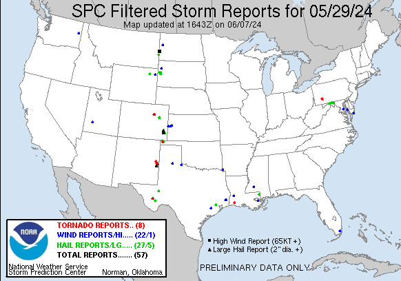
| Tornado Reports (CSV) (Raw Tornado CSV)(?) |
|---|
Time | | Location | County | State | Lat | Lon | Comments |
| 1845 | | 7 W Lacassine National | Cameron | LA | 2998 | 9304 | EF Unknown tornado observed by NWS Staff southeast of the office within the Cameron Prairie National Wildlife Refuge. Time estimated by radar. (LCH) |
| 1939 | | 8 NNE Byers | Adams | CO | 3982 | 10419 | Storm chaser reported video and photographic evidence of a small landspout that persisted for about 5 minutes. Location was estimated by spotter and radar data. (BOU) |
| 2006 | | 2 SSW Leader | Adams | CO | 3987 | 10408 | Trained spotter reported a landspout south of their location. Location estimated. Unknown duration. (BOU) |
| 2216 | | McChesneytown-Loyalhann | Westmoreland | PA | 4031 | 7936 | Video of a brief tornado provided from along Route 982. Damage to trees and shingles reported. Additional details will be provided at a later time. (PBZ) |
| 2250 | | 8 ENE Alpine | Brewster | TX | 3042 | 10355 | [Landspout] Observed two separate landspouts over the course of 15 minutes. (MAF) |
| 0245 | | 13 NW Ranchvale | Curry | NM | 3462 | 10347 | Train spotter documented a brief tornado relayed by Curry Co emergency manager. No damage was reported as the tornado was brief and in rural land. Damage rating EF-Unkn (ABQ) |
| 0422 | | 3 W Cannon Air Force Ba | Curry | NM | 3438 | 10336 | Photo from Roosevelt County Emergency Manager shows a rope funnel apparently in contact with the ground. (ABQ) |
| 0534 | | 10 NW Boise City | Cimarron | OK | 3682 | 10265 | A storm chaser photographed a large cone tornado that was in open country grasslands and no damage was reported or likely occurred given the location (EFu). The tornado (AMA) |
| Hail Reports (CSV) (Raw Hail CSV)(?) |
|---|
Time | Size | Location | County | State | Lat | Lon | Comments |
| 1855 | 100 | 2 N Rector | Westmoreland | PA | 4022 | 7924 | Off of State Route 711 (PBZ) |
| 2015 | 125 | 3 NNE Rozet | Campbell | WY | 4432 | 10519 | Accompanied by 40 mph winds and heavy rain (UNR) |
| 2050 | 100 | 1 E Little Orleans | Morgan | WV | 3962 | 7837 | There were a few reports of hail up to quarter size near the Morgan County line. (LWX) |
| 2059 | 100 | 1 NE Berkeley Spgs | Morgan | WV | 3964 | 7822 | Trained spotter reported quarter size hail near Jimtown Rd in Berkeley Springs. (LWX) |
| 2115 | 100 | 3 W Cherry Run | Morgan | WV | 3963 | 7809 | There were several reports of quarter size hail near and east of Berkeley Springs. (LWX) |
| 2125 | 100 | Falling Waters | Berkeley | WV | 3956 | 7789 | There were several reports of hail up to quarter size in Falling Waters. (LWX) |
| 2130 | 125 | 1 WSW Halfway | Washington | MD | 3961 | 7779 | Hail up to half dollar size was reported between Clear Spring and Hagerstown. (LWX) |
| 2132 | 100 | 2 E Hedgesville | Berkeley | WV | 3956 | 7795 | Dime to quarter size hail was observed near Spring Mills. (LWX) |
| 2210 | 150 | 3 N Hilshire Village | Harris | TX | 2984 | 9548 | Video provided by broadcast media indicated half dollar to ping pong ball sized hail in progress near Hwy 290 in NW Houston. (HGX) |
| 2217 | 125 | 7 SSE Sundance | Crook | WY | 4431 | 10431 | (UNR) |
| 2222 | 125 | 20 NNE Baker | Fallon | MT | 4659 | 10408 | (BYZ) |
| 2250 | 100 | Saint Onge | Lawrence | SD | 4455 | 10372 | (UNR) |
| 2250 | 150 | Beach | Golden Valley | ND | 4692 | 10401 | Estimated wind gusts to 70 mph. Hail ongoing at the time of the call. (BIS) |
| 2251 | 175 | Beach | Golden Valley | ND | 4691 | 10400 | Reports hail from 1 inch to 1.75 inch diameter. Duration was approximately 9 minutes. Reports car dents ... damaged shingles ... and broken car windows. (BIS) |
| 2251 | 175 | Beach | Golden Valley | ND | 4692 | 10400 | Ping pong to golf ball sized hail ... bouncing off the ground. (BIS) |
| 2252 | 200 | Beach | Golden Valley | ND | 4692 | 10400 | Multiple photos and videos of large hail in Beach. Estimated largest size of around 2 inch in diameter. Photos of vehicle and home window damage as well. Time estimated (BIS) |
| 2254 | 150 | 3 W Vale | Butte | SD | 4461 | 10347 | (UNR) |
| 2254 | 150 | Beach | Golden Valley | ND | 4692 | 10401 | Hail began one minute prior to report and was ongoing at time of call. (BIS) |
| 2257 | 100 | Beach | Golden Valley | ND | 4692 | 10400 | Estimated 50 MPH wind. (BIS) |
| 2300 | 100 | Newell | Butte | SD | 4472 | 10342 | (UNR) |
| 2301 | 175 | Beach | Golden Valley | ND | 4692 | 10400 | Also reported strong winds. (BIS) |
| 2306 | 100 | 2 WSW Vale | Butte | SD | 4461 | 10343 | mPING report (UNR) |
| 2314 | 100 | 11 N Altuda | Brewster | TX | 3046 | 10347 | Report from mPING: Quarter (1.00 in.). Time adjusted based on radar. (MAF) |
| 2317 | 100 | 2 S Crossroads | Pearl River | MS | 3075 | 8977 | 1 inch hail near Old River WMA HQ relayed via social media. (LIX) |
| 2352 | 100 | Sturgis | Meade | SD | 4441 | 10351 | Multiple reports of quarter size hail (UNR) |
| 0008 | 175 | 6 WSW Thurman | Lincoln | CO | 3955 | 10333 | Hail lasted for 20 minutes total. Largest hail was estimated to be about golf ball sized hail. (BOU) |
| 0019 | 100 | 1 WSW Marathon | Brewster | TX | 3020 | 10325 | Largest hail: 1.00 in ... . Average: 0.50 in. Damage: shredded leaves ... car dents ... damaged shingles ... broken house windows Depth: 4.5 Comments: Ice flows up to 24 in. (MAF) |
| 0021 | 100 | Marathon | Brewster | TX | 3021 | 10324 | Accumulating quarter sized hail on the west side of Marathon. (MAF) |
| 0049 | 150 | 8 SSW Thurman | Lincoln | CO | 3949 | 10327 | Photo provided of a hailstone slightly larger than a ping pong ball. Time estimated by radar. (BOU) |
| 0127 | 100 | 10 S Lamar | Prowers | CO | 3794 | 10261 | Report from mPING: Quarter (1.00 in.). (PUB) |
| 0135 | 175 | 11 S Lamar | Prowers | CO | 3793 | 10261 | Report from mPING: Golf Ball (1.75 in.). (PUB) |
| 0139 | 125 | 10 S Lamar | Prowers | CO | 3794 | 10261 | Report from mPING: Half Dollar (1.25 in.). (PUB) |
| 0140 | 175 | 10 S Lamar | Prowers | CO | 3794 | 10261 | Report from mPING: Golf Ball (1.75 in.). (PUB) |
| 0142 | 225 | 16 S Lamar | Prowers | CO | 3786 | 10261 | Report from mPING: Hen Egg+ (2.25 in.). (PUB) |
| 0145 | 200 | Lamar | Prowers | CO | 3809 | 10262 | Picture of hail on social media ... shown compared to a quarter. The hail is approximately twice the diameter of the coin. (PUB) |
| 0222 | 175 | 3 SSW Grandfalls | Pecos | TX | 3130 | 10288 | (MAF) |
| 0236 | 100 | 17 N Two Buttes | Prowers | CO | 3780 | 10236 | Report from mPING: Quarter (1.00 in.). (PUB) |
| 0430 | 175 | 4 SE Cannon Air Force B | Curry | NM | 3435 | 10326 | Near the Restoration Dairy located south of Clovis on County Road 6. (ABQ) |
| 0430 | 250 | Cannon Air Force Base | Curry | NM | 3438 | 10332 | (ABQ) |
| 0440 | 275 | 4 SE Cannon Air Force B | Curry | NM | 3434 | 10326 | Broke window in house. (ABQ) |
| 0453 | 175 | 11 ENE Black Mesa Park | Cimarron | OK | 3692 | 10270 | (AMA) |
| 0506 | 300 | 1 E Portales | Roosevelt | NM | 3418 | 10333 | (ABQ) |
| 0510 | 250 | 1 SW Portales | Roosevelt | NM | 3417 | 10335 | Report forwarded by Amarillo ... TX media outlet. (ABQ) |
| 0549 | 150 | 10 N Boise City | Cimarron | OK | 3687 | 10251 | (AMA) |
| Wind Reports (CSV) (Raw Wind CSV)(?) |
|---|
Time | Speed | Location | County | State | Lat | Lon | Comments |
| 2003 | UNK | 2 NNW Huntingtown | Calvert | MD | 3865 | 7663 | Tree down near Mill Branch Rd and Huntingtown Rd. (LWX) |
| 2004 | UNK | 2 SW Mount Harmony | Calvert | MD | 3869 | 7663 | Tree down near the 7600 block of Lake Shore Dr. (LWX) |
| 2028 | 61 | 6 WSW East New Orleans | Orleans | LA | 3004 | 9003 | ASOS station KNEW New Orleans Lakefront Airport. (LIX) |
| 2050 | 58 | Homestead | Miami-Dade | FL | 2547 | 8047 | Mesonet station Fswn Miami Dade College Homestead reported a 58 mph gust. Emergency manager forwarded some pictures of a couple large branches snapped off of a tree. (MFL) |
| 2105 | UNK | 3 WNW Bucktown | Dorchester | MD | 3848 | 7607 | Large tree down on the 4400 block of Maple Dam Road. Time estimated from radar data. (AKQ) |
| 2112 | UNK | Brookhaven | Lincoln | MS | 3159 | 9044 | A few trees down in the Brookhaven area. Caused by winds estimated 30-40 mph. (JAN) |
| 2217 | 60 | 7 SSE Sundance | Crook | WY | 4431 | 10431 | (UNR) |
| 2243 | 69 | 7 WSW Hoover | Butte | SD | 4507 | 10340 | (UNR) |
| 2300 | 75 | 1 ENE Beach | Golden Valley | ND | 4692 | 10398 | REPORTED AT BEACH AIRPORT. (BIS) |
| 2330 | UNK | Chincoteague | Accomack | VA | 3794 | 7536 | Tree fell on top of camper on Crane Lane in Chincoteague. (AKQ) |
| 2350 | UNK | 2 WNW Bundick Lake | Beauregard | LA | 3076 | 9313 | Sheriff office reports tree down at hwy 394 and Pumpkin Loop. Time estimated by radar. (LCH) |
| 2350 | UNK | 2 W Spokane | Spokane | WA | 4766 | 11745 | 6 inch diameter branches down. (OTX) |
| 0016 | 68 | 9 S Arnegard | McKenzie | ND | 4767 | 10343 | NDAWN station located 8SE Antelope Creek. (BIS) |
| 0050 | 63 | 2 SSW Adamsville | Beaver | UT | 3822 | 11282 | Mesonet station PC331 Minersville Reservoir. (SLC) |
| 0139 | UNK | East Bernard | Wharton | TX | 2953 | 9607 | Wind gusts from ongoing thunderstorms resulted in the collapse of a metal bleacher at East Bernard HS. Winds were estimated to be approximately 50 mph. Time estimated b (HGX) |
| 0145 | UNK | 1 NNE Silsbee | Hardin | TX | 3036 | 9417 | Emergency Manager reports trees down in and north of Silsbee. Time estimated by radar. (LCH) |
| 0149 | 58 | 8 NNE Tribune | Greeley | KS | 3858 | 10170 | wxlink station 8 NNE Tribune ... KS. (GLD) |
| 0201 | UNK | 3 ENE Silsbee (UN | ) | | | | |
| 0201 | UNK | 3 ENE Silsbee | Hardin | TX | 3035 | 9413 | Widespread power outages reported east of Silsbee in association with thunderstorm passage. (LCH) |
| 0227 | 62 | 16 SSE Wallace | Logan | KS | 3870 | 10147 | Aero B Ranch WUNderground. (GLD) |
| 0520 | UNK | 14 NW Horace | Greeley | KS | 3863 | 10196 | Corrects previous tstm wnd dmg report from 14 NW Horace. 10 power poles snapped ... 2 irrigation pivots blown over in the area of CR D and 7; no idea yet regarding the n (GLD) |
| 0741 | 58 | 7 ESE Silverton | Briscoe | TX | 3445 | 10119 | (LUB) |
| 0743 | 59 | 7 ESE Silverton | Briscoe | TX | 3445 | 10119 | (LUB) |
| 0824 | UNK | Foreman | Little River | AR | 3372 | 9440 | Sheriffs office reported trees down throughout Little River County. (SHV) |
| 0926 | 60 | 3 W Goodlett | Hardeman | TX | 3434 | 9994 | (OUN) |