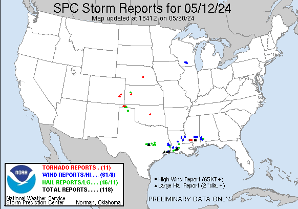
| Tornado Reports (CSV) (Raw Tornado CSV)(?) |
|---|
Time | | Location | County | State | Lat | Lon | Comments |
| 1907 | | 5 SE Keyes | Cimarron | OK | 3676 | 10218 | [Landspout] Multiple reports and pictures of a landspout to the south of Keyes. (AMA) |
| 1920 | | 3 S Eva | Texas | OK | 3676 | 10190 | [Landspout] Picture of a landspout near the intersection of Highways 64 and 95 ... also known as the four corners region of Texas County. (AMA) |
| 1930 | | 3 WNW Mcclave | Bent | CO | 3815 | 10290 | [Landspout] Corrects previous tornado report from 3 WNW Mcclave. picture of landspout taken west of Lamar. (PUB) |
| 2005 | | 5 N Hasty | Bent | CO | 3818 | 10297 | [Landspout] Colorado Storm Chasers photo. Time and Location estimated. (PUB) |
| 2130 | | 1 N Eads | Kiowa | CO | 3850 | 10278 | [Landspout] (PUB) |
| 2245 | | 4 W Saint Paul | Howard | NE | 4121 | 9853 | [Landspout] Multiple reports and video of landspout tornado. (GID) |
| 0038 | | 4 WNW Manning | Scott | KS | 3858 | 10080 | [Landspout] (DDC) |
| 0832 | | 1 WSW Topeka | Lawrence | MS | 3141 | 9020 | This brief EF1 tornado touched down just west of Holmesville Road and damaged the Calvary United Church ... then quickly dissipated just east of the road. This tornado d (JAN) |
| 0837 | | 4 ENE Topeka | Lawrence | MS | 3144 | 9013 | This brief EF1 tornado touched down just west of Renfroe Road and Gaskin Lane. This tornado developed on the north side of a intense downburst and wind swath as a brief (JAN) |
| 0854 | | 1 NNW Society Hall | Jefferson Davis | MS | 3142 | 8989 | This brief EF1 tornado touched down basically along Highway 13 at Wilburn Dyess Road in the Society Hill community. This tornado developed on the north side of a intens (JAN) |
| 0934 | | 5 SE Luther | Lincoln | OK | 3560 | 9714 | A home experienced partial loss of its roof from a tornado. (OUN) |
| Hail Reports (CSV) (Raw Hail CSV)(?) |
|---|
Time | Size | Location | County | State | Lat | Lon | Comments |
| 1333 | 100 | 2 E Copperas Cove | Coryell | TX | 3112 | 9787 | Delayed Report from mPING: Quarter (1.00 in.). (FWD) |
| 1343 | 100 | Killeen | Bell | TX | 3110 | 9772 | Delayed Report - Quarter hail reported on the south side of Killeen. (FWD) |
| 1346 | 150 | 7 ESE Lott | Falls | TX | 3118 | 9692 | delayed report - ping pong size hail reported in Cedar Spring. (FWD) |
| 1350 | 100 | Harker Heights | Bell | TX | 3106 | 9765 | Delayed Report - Penny to Quarter hail reported in Harker Heights. (FWD) |
| 1406 | 175 | Belton | Bell | TX | 3107 | 9746 | Delayed Report - Hail up to golf balls reported in Belton. (FWD) |
| 1407 | 125 | 1 E Belton | Bell | TX | 3106 | 9745 | Delayed Report from mPING: Half Dollar (1.25 in.). (FWD) |
| 1408 | 200 | 3 SSW Belton | Bell | TX | 3103 | 9748 | Delayed Report - Photo of golf ball to egg size hail from Belton. (FWD) |
| 1420 | 200 | 2 SSE Temple | Bell | TX | 3107 | 9735 | Photo of 2 inch hail in south Temple - delayed report. (FWD) |
| 1427 | 175 | 4 NNE Temple | Bell | TX | 3114 | 9733 | Delayed report - Hail up to golf ball size reported in Temple. (FWD) |
| 1454 | 125 | 10 NW Marquez | Limestone | TX | 3137 | 9634 | Delayed Report from mPING Half Dollar (1.25 in.). (FWD) |
| 1510 | 100 | Calvert | Robertson | TX | 3098 | 9667 | Photo of quarter hail on social media. (FWD) |
| 1528 | 100 | Franklin | Robertson | TX | 3102 | 9649 | Photo shared of quarter hail in Franklin. Time estimated from radar. (FWD) |
| 1549 | 125 | 10 SW Normangee | Brazos | TX | 3096 | 9627 | Report from mPING: Half Dollar (1.25 in.). (HGX) |
| 1715 | 200 | 8 E Old River-Winfree | Chambers | TX | 2989 | 9470 | Picture of hailstone roughly the size of an egg reported on social media. (HGX) |
| 1738 | 250 | 1 NNW Hamshire | Jefferson | TX | 2988 | 9432 | Several pictures from the public and media of large hail north of Hampshire. (LCH) |
| 1745 | 150 | Fannett | Jefferson | TX | 2993 | 9425 | Video of ping pong ball size hail at Fannett. (LCH) |
| 1805 | 150 | 1 SSE Bunkie | Avoyelles | LA | 3094 | 9218 | Several photos and public reports of hail in and south of Bunkie. Largest reported size of 1.50 inches. (LCH) |
| 1813 | 100 | 1 S Nederland | Jefferson | TX | 2995 | 9399 | Report from mPING: Quarter (1.00 in.). (LCH) |
| 1818 | 100 | Port Arthur | Jefferson | TX | 2990 | 9393 | Call from the public about 3/4 to quarter sized hail. (LCH) |
| 1820 | 200 | 1 W Groves | Jefferson | TX | 2994 | 9393 | Hail from golfball to hen egg size reported at Groves. (LCH) |
| 1901 | 175 | Bleakwood | Newton | TX | 3069 | 9382 | Photo received of Golf Ball size hail at Bleakwood. (LCH) |
| 1926 | 100 | 9 E Morse | Hutchinson | TX | 3605 | 10131 | Report received from mPing. (AMA) |
| 1930 | 100 | 9 SW Spearman | Hansford | TX | 3608 | 10127 | Report received from mPing. (AMA) |
| 1937 | 175 | 2 NE Grand Lake | Cameron | LA | 3005 | 9324 | NWS employee reports golf ball size hail. (LCH) |
| 1959 | 150 | 2 E Ragley | Beauregard | LA | 3051 | 9321 | Public reports large hail to ping pong ball size was blown into the side of their camper resulting in windows being destroyed. (LCH) |
| 2016 | 175 | Bell City | Calcasieu | LA | 3011 | 9296 | Golf Ball size hail reported at 3:16PM over Bell City area. (LCH) |
| 2023 | 250 | 1 W Jennings | Jefferson Davis | LA | 3022 | 9267 | Photos submitted of large hail and a ruler. Looks to be a little less than 2.50 inches. (LCH) |
| 2030 | 250 | Jennings | Jefferson Davis | LA | 3022 | 9266 | Photo of 2.50 inch hail in downtown Jennings. (LCH) |
| 2030 | 175 | 1 NW Jennings | Jefferson Davis | LA | 3023 | 9267 | Report from mPING: Golf Ball (1.75 in.). (LCH) |
| 2032 | 100 | Jennings | Jefferson Davis | LA | 3023 | 9266 | Report of hail at 1.00 inch falling in Jennings. (LCH) |
| 2035 | 200 | 1 NNE Jennings | Jefferson Davis | LA | 3024 | 9265 | Photo of hen egg size hail falling at Jennings. (LCH) |
| 2039 | 175 | Iota | Acadia | LA | 3033 | 9250 | Public reports golf ball size hail at Iota. (LCH) |
| 2040 | 200 | 1 W Evangeline | Acadia | LA | 3026 | 9258 | Pulbic sent several photos of large hail. Largest estimated size of near 2 1/4. (LCH) |
| 2043 | 225 | Jennings | Jefferson Davis | LA | 3023 | 9265 | Report from mPING: Hen Egg+ (2.25 in.). (LCH) |
| 2049 | 200 | Iota | Acadia | LA | 3033 | 9249 | Public report of 2.00 inch hail at Iota. (LCH) |
| 2122 | 100 | Church Point | Acadia | LA | 3041 | 9222 | Photos of different sized hail in the Church Point area. Largest size appears to be around an inch. (LCH) |
| 2135 | 175 | 3 S Eva | Texas | OK | 3676 | 10191 | Hail covering the highway at the intersection of Highways 64 and 95. Most hail was about nickel size with the largest being golfball size. Report/video via social media (AMA) |
| 2200 | 175 | 12 N Texhoma | Texas | OK | 3668 | 10179 | Mentions off possibly bigger hail stones present. (AMA) |
| 2216 | 175 | 5 NW Goodwell | Texas | OK | 3665 | 10170 | Via spotter network. (AMA) |
| 2253 | 100 | 4 NE Goodwell | Texas | OK | 3662 | 10158 | Report from mPing. (AMA) |
| 2300 | 100 | 6 N Texhoma | Texas | OK | 3659 | 10180 | Hail up to quarter size. Picture via social media. (AMA) |
| 2305 | 150 | 1 SSE Bunkie | Avoyelles | LA | 3094 | 9218 | Corrects previous hail report from 1 SSE Bunkie. Several photos and public reports of hail in and south of Bunkie. Largest reported size of 1.50 inches. (LCH) |
| 2315 | 100 | 7 NW The Monument Rocks | Logan | KS | 3884 | 10085 | Report from mPING: Quarter (1.00 in.). (GLD) |
| 1047 | 100 | Chatom | Washington | AL | 3146 | 8825 | Emergency management reports quarter size hail the Chatom Community. (MOB) |
| 1100 | 175 | 2 N Sunflower | Washington | AL | 3140 | 8804 | Multiple reports of golf ball size hail in the Wagarville and Sunflower Communities. Time estimated on radar. (MOB) |
| 1113 | 175 | 3 NNW Choctaw Bluff | Clarke | AL | 3143 | 8782 | Emergency management reports golf ball size hail in the Rockville Community. (MOB) |
| Wind Reports (CSV) (Raw Wind CSV)(?) |
|---|
Time | Speed | Location | County | State | Lat | Lon | Comments |
| 1412 | UNK | 3 NE Belton | Bell | TX | 3110 | 9744 | Wide swath of tree damage reported near TX317 and Old Waco Rd including trees snapped and fencing blown down. (FWD) |
| 1811 | UNK | 2 SW Nederland | Jefferson | TX | 2995 | 9402 | Helicopter spun around and a boarding stairway was blown down the tarmac. The ASOS had winds 22G56MPH before the sensor stopped reporting for about 10 minutes. Higher w (LCH) |
| 1959 | UNK | 2 NNE Ragley | Beauregard | LA | 3054 | 9322 | Public reports multiple trees down and power outages in the Ragley community. Large hail destroyed windows. (LCH) |
| 2002 | UNK | Ragley | Beauregard | LA | 3051 | 9323 | Corrects previous tstm wnd dmg report from Ragley. A few reports of wind damage in the area. A trampoline flipped ... a power pole bent ... and a barn destroyed. (Time co (LCH) |
| 2004 | UNK | 3 SW Ragley | Beauregard | LA | 3048 | 9327 | Report from public of trampolines flipped ... Telephone poles bent over road ... many trees snapped. Public reports marble size hail on ground at time of report given to (LCH) |
| 2030 | UNK | 3 SW Jasper | Jasper | TX | 3089 | 9404 | Multiple trees blown down. (LCH) |
| 2045 | UNK | Elton | Jefferson Davis | LA | 3048 | 9269 | A few branches down along with a tree down on a truck. (LCH) |
| 2125 | UNK | 1 ENE Cross Plains | Dane | WI | 4312 | 8963 | Report of trees down. No specific location given at this time. Time estimated from radar. (MKX) |
| 2125 | UNK | Mazomanie | Dane | WI | 4318 | 8980 | Report of trees down. No specific location given at this time. Time estimated from radar. (MKX) |
| 2134 | UNK | Middleton | Dane | WI | 4311 | 8951 | Report of trees down. No specific location given at this time. Time estimated from radar. (MKX) |
| 2140 | UNK | 4 SSW Shorewood Hills | Dane | WI | 4303 | 8948 | Large tree branch broken with photo submitted. Report of trees down near Raymond Road. Relayed via WISC TV. Time estimated from radar. (MKX) |
| 2217 | UNK | Ragley | Beauregard | LA | 3051 | 9323 | A few reports of wind damage in the area. A trampoline flipped ... a power pole bent ... and a barn destroyed. (LCH) |
| 2315 | UNK | 4 ENE Sam Rayburn Dam | Jasper | TX | 3107 | 9405 | Resident reports several trees blown down due to possible tornado. Trees damaged a home. (LCH) |
| 2321 | UNK | 3 SSW Jasper | Jasper | TX | 3088 | 9402 | Reports of multiple flooded locations on FM 252. (LCH) |
| 2340 | UNK | 4 ENE Sam Rayburn Dam | Jasper | TX | 3109 | 9404 | Several trees blown down. Witnesses say it was a possible tornado. (LCH) |
| 0525 | UNK | 2 NNE Leland | Catahoula | LA | 3185 | 9171 | Significant type wind damage in the N/NE part of the parish ... Hwy 913 and Hwy 8 ... around Sicily Island and N. Numerous trees down ... lines down. Large areas of corn l (JAN) |
| 0532 | UNK | 1 S Wisner | Franklin | LA | 3197 | 9166 | Significant damage across the southern part of the parish ... located around Wisner. Large amounts of old and mobile homes damaged. Various large trees uprooted ... with (JAN) |
| 0605 | UNK | 4 E Pineville | Rapides | LA | 3135 | 9235 | Report from mPING: 1-inch tree limbs broken; Shingles blown off. (LCH) |
| 0610 | UNK | 4 N Port Gibson | Claiborne | MS | 3201 | 9098 | Trees down on Grand Gulf Road. (JAN) |
| 0613 | UNK | Port Gibson | Claiborne | MS | 3196 | 9098 | Trees down in Port Gibson. (JAN) |
| 0702 | UNK | 1 NNW Natchez | Adams | MS | 3156 | 9140 | Trees and powerlines were down in Natchez. Additional trees and powerlines were down across the county. (JAN) |
| 0810 | UNK | 1 E Bogue Chitto | Lincoln | MS | 3143 | 9043 | Tree uprooted. (JAN) |
| 0830 | UNK | Topeka | Lawrence | MS | 3142 | 9018 | Reports of trees down on both Holmesville Road and Robert Tynes Road. One resident was trapped in a trailer on Robert Tynes Road. Time estimated based on radar. (JAN) |
| 0831 | 105 | 1 WSW Topeka | Lawrence | MS | 3141 | 9021 | This intense downburst started N of Jayess between China Grove Road and Holmesville Road. Max winds were 90-105 mph. This downburst intensified quickly as it approached (JAN) |
| 0833 | UNK | 2 E Topeka | Lawrence | MS | 3141 | 9015 | Report of trees down on Highway 27S. Time estimated based on radar. (JAN) |
| 0835 | 100 | 1 E Topeka | Lawrence | MS | 3142 | 9016 | *** 1 INJ *** This intense downburst swath occurred generally in the Highway 27 portion of Southern Lawrence county near Robert Tynes ... Divide and Renfroe Roads. Numer (JAN) |
| 0845 | 90 | 3 S Arm | Lawrence | MS | 3146 | 9002 | This swath of significant winds was noted along River Road near the Oak Vale area of Lawrence County. Damage was mainly to numerous uprooted and snapped trees along Riv (JAN) |
| 0850 | 105 | 1 N Society Hill | Jefferson Davis | MS | 3142 | 8989 | This significant swath of intense winds started in the Oak Vale community in Jefferson Davis county and moved SE through the Society Hill community of Jefferson Davis c (JAN) |
| 0850 | UNK | 1 E Oak Vale | Jefferson Davis | MS | 3144 | 8995 | Multiple downed trees in the Oak Vale area. (JAN) |
| 0853 | UNK | 1 NW Goss | Marion | MS | 3137 | 8990 | Numerous trees down ... many across roads ... including Hwy 44 and 13 N. (JAN) |
| 0853 | UNK | Society Hall | Jefferson Davis | MS | 3141 | 8989 | Multiple trees down in the Society Hill community. (JAN) |
| 0854 | 105 | 1 NNW Society Hall | Jefferson Davis | MS | 3142 | 8989 | Corrects previous tornado report from 1 NNW Society Hall. After additional drone aerial imagery and perspective ... the damage along Highway 13 at Wilburn Dyess Road in (JAN) |
| 0855 | UNK | Taylorsville | Smith | MS | 3183 | 8943 | Numerous trees down. (JAN) |
| 0855 | UNK | 1 NE Taylorsville | Smith | MS | 3184 | 8942 | Leaf Valley veterinarian clinic lost roof. (JAN) |
| 0857 | UNK | Bunker Hill | Marion | MS | 3138 | 8980 | Multiple trees down and power lines ... roads blocked around the Bunker Hill community and Hwy 35. (JAN) |
| 0900 | UNK | 2 W Newton | Newton | TX | 3085 | 9378 | Homeowner called to report wind damage at her residence. Trees were snapped between her and neighbors. Mentioned twisted cedar trees ... lots of debris all over the plac (LCH) |
| 0900 | UNK | 2 SSW Bassfield | Jefferson Davis | MS | 3148 | 8976 | Multiple trees down around Bassfield and Hwy 35 S areas. (JAN) |
| 0902 | UNK | Improve | Marion | MS | 3134 | 8970 | Multiple trees down in the Improve community. (JAN) |
| 0902 | 110 | 1 S Bunker Hill | Marion | MS | 3137 | 8980 | This significant swath of intense winds started in the Oak Vale community in Jefferson Davis county and moved SE through the Society Hill community of Jefferson Davis c (JAN) |
| 0907 | UNK | 4 NNE Soso | Jasper | MS | 3181 | 8925 | Report of trees downed on Highway 533 in southern Jasper County. Time estimated based on radar. (JAN) |
| 0910 | UNK | 2 W Moss | Jasper | MS | 3182 | 8921 | Corrects previous tstm wnd dmg report from 1 NW Shady Grove. Trees down on Highway 15 and County Road 8. Time estimated based on radar. (JAN) |
| 0915 | UNK | 2 ESE Hickory Grove | Lamar | MS | 3139 | 8961 | Lot of trees & debris down on hwy 44 in Sumrall. (JAN) |
| 0915 | UNK | 1 NW Shady Grove | Jones | MS | 3176 | 8917 | Trees down on Highway 15. Time estimated based on radar. (JAN) |
| 0918 | UNK | 3 ENE Moss | Jasper | MS | 3183 | 8913 | Trees down on County Road 23. Time estimated based on radar. (JAN) |
| 0920 | UNK | 3 N Bellevue | Lamar | MS | 3135 | 8947 | Corrects previous tstm wnd dmg report from 3 N Bellevue. Several trees reported down at 6419 Old Highway 42. (JAN) |
| 0923 | UNK | 2 N Oak Grove | Lamar | MS | 3132 | 8941 | Tin canopy collapsed at a Sonic Drive-Thru off Old Hwy 11. (JAN) |
| 0925 | UNK | 1 S Laurel | Jones | MS | 3168 | 8915 | Tree down on a house on 16th Ave. (JAN) |
| 0925 | UNK | Sandersville | Jones | MS | 3179 | 8904 | Trees down. (JAN) |
| 0927 | UNK | 2 NE Rawls Springs | Forrest | MS | 3139 | 8937 | Several trees down in the northern part of the county. (JAN) |
| 0930 | UNK | 3 N Bellevue | Lamar | MS | 3135 | 8947 | Several trees reported down at 6419 Old Highway 42. (JAN) |
| 0931 | UNK | 2 SSW Lux | Forrest | MS | 3142 | 8941 | Several trees damaged to the east of Hwy 49. (JAN) |
| 0935 | 80 | 1 S Petal | Forrest | MS | 3132 | 8925 | This swath of wind started on the south side of Petal near Boxtel Street and Crabapple Drive and moved SSE across Carterville Road into the Carterville community. Initi (JAN) |
| 0937 | UNK | 3 N Petal | Forrest | MS | 3138 | 8925 | Multiple trees down in the Leeville and Petal areas. (JAN) |
| 0938 | 90 | 2 S Eastabuchie | Forrest | MS | 3140 | 8928 | This swath of significant straight line winds started near the Leaf River and moved generally ESE. Heaviest damage was along Highway 11 and then again along Leeville ne (JAN) |
| 0939 | UNK | 3 WNW Macedonia | Forrest | MS | 3141 | 8922 | Tree down on a house on Show Road with one injury reported. (JAN) |
| 0941 | UNK | 4 S Macedonia | Forrest | MS | 3132 | 8916 | Small trees and large limbs down in the area. One tree punctured the roof of a home. Report relayed via NWS Mobile. (JAN) |
| 0948 | UNK | 3 SSW Eucutta | Wayne | MS | 3177 | 8889 | Several trees down on Jim Brownlee Rd. Time estimated by radar. (MOB) |
| 0950 | UNK | 4 S Macedonia | Forrest | MS | 3132 | 8916 | Multiple large limbs and small trees down with a large limb puncturing a roof. (JAN) |
| 1041 | UNK | Frankville | Washington | AL | 3165 | 8815 | Two mobile homes damaged by trees in Frankville ... AL. (MOB) |
| 1047 | UNK | Chatom | Washington | AL | 3146 | 8825 | Multiple trees down in Chatom ... AL. Time estimated by radar. (MOB) |
| 1110 | UNK | Mcintosh | Washington | AL | 3127 | 8803 | Multiple trees down in the McIntosh Community. Time estimated by radar. (MOB) |


 @NWSSPC