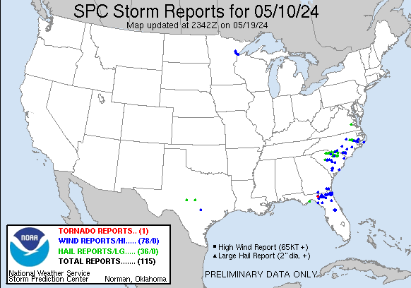
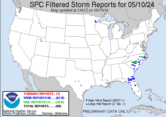
| Tornado Reports (CSV) (Raw Tornado CSV)(?) |
|---|
Time | | Location | County | State | Lat | Lon | Comments |
| 1202 | | 7 SE Lee | Madison | FL | 3035 | 8321 | End point of EF1 tornado that moved through southern Madison county. (TAE) |
| Hail Reports (CSV) (Raw Hail CSV)(?) |
|---|
Time | Size | Location | County | State | Lat | Lon | Comments |
| 1553 | 175 | Alligator Point | Franklin | FL | 2990 | 8440 | Golf ball sized hail falling in Alligator Point on Alligator Dr. (TAE) |
| 1816 | 100 | 3 NNE Tradesville | Chesterfield | SC | 3481 | 8053 | Quarter sized hail reported at 2:16p near the Wolf Pond Rd and SC 207 by Buford SC Fire. (CAE) |
| 1855 | 100 | Chesterfield | Chesterfield | SC | 3474 | 8008 | Chesterfield county emergency manager reported quarter sized hail in Chesterfield city limits. Time estimated. (CAE) |
| 1855 | 175 | Ruby | Chesterfield | SC | 3475 | 8017 | Broadcast meteorologist reported ping-pong to golf ball sized hail in Ruby at 255pm. (CAE) |
| 1855 | 175 | Lowrys | Chester | SC | 3480 | 8123 | Golf ball hail. (GSP) |
| 1900 | 100 | Lowrys | Chester | SC | 3481 | 8124 | (GSP) |
| 1905 | 125 | Richburg | Chester | SC | 3472 | 8102 | Picture of 1.0-1.25 inch hail in the town of Richburg. (GSP) |
| 1907 | 100 | 3 NE Richburg | Chester | SC | 3475 | 8098 | Report from mPING: Quarter (1.00 in.). (GSP) |
| 1912 | 150 | Cheraw | Chesterfield | SC | 3470 | 7989 | Broadcast meteorologist passed on a public report with photo of roughly ping-pong sized hail in Cheraw. (CAE) |
| 1915 | 100 | 2 NW Cheraw | Chesterfield | SC | 3471 | 7991 | Skywarn spotters noted several reports of quarter sized hail just north of Cheraw along Highway 52 at 315pm. (CAE) |
| 1920 | 125 | Fort Lawn | Chester | SC | 3470 | 8090 | IBHS Meteorologist reported up to 1.3 inch diameter hail in Fort Lawn. (GSP) |
| 1932 | 100 | 1 S Springdale | Lancaster | SC | 3468 | 8079 | Public report of dime and quarter sized hail near Lancaster golf course. Time estimated. (CAE) |
| 1932 | 100 | 1 SW Springdale | Lancaster | SC | 3469 | 8079 | Public report with photos of quarter sized hail just south of Lancaster. Time estimated. (CAE) |
| 1935 | 150 | Cherokee | San Saba | TX | 3098 | 9871 | Marble to ping pong size hail in Cherokee. (SJT) |
| 1936 | 100 | Bennettsville | Marlboro | SC | 3463 | 7969 | Quarter-sized hail fell in Bennettsville. Photo evidence tweeted by broadcast media. Event time estimated by radar. (ILM) |
| 1947 | 150 | 3 NW Kershaw | Lancaster | SC | 3457 | 8062 | Corrects previous tstm wnd dmg report from 3 NW Kershaw. Public report with video of ping pong ball sized hail at Andrew Jackson High School northwest of Kershaw. Time (CAE) |
| 1951 | 100 | 2 N Kershaw | Lancaster | SC | 3458 | 8058 | Public report of quarter sized hail with photos on the north side of Kershaw. (CAE) |
| 1955 | 100 | 3 NE Kershaw | Lancaster | SC | 3458 | 8054 | Public report and video of quarter sized at the gold mine in Kershaw. (CAE) |
| 2021 | 175 | Garland | Sampson | NC | 3478 | 7839 | (RAH) |
| 2024 | 150 | 1 NE Saratoga | Wilson | NC | 3566 | 7777 | Estimated Ping Pong Size hail reported in Saratoga ... NC. Hail Damage to car and Metal Roof of pavilion. (RAH) |
| 2029 | 100 | Charles City | Charles City | VA | 3734 | 7707 | Quarter size hail covering the ground. (AKQ) |
| 2030 | 100 | Mcbee | Chesterfield | SC | 3447 | 8026 | Public report of dime sized and quarter sized hail at Highway 151 and 5th Street in McBee. (CAE) |
| 2030 | 125 | New Hope | Charles City | VA | 3734 | 7706 | (AKQ) |
| 2041 | 100 | 3 S Fountain | Pitt | NC | 3563 | 7764 | Still hailing at this time. Estimated wind gust of 30 to 40 mph with initial outflow. (MHX) |
| 2044 | 175 | 1 ENE Proctorville | Robeson | NC | 3448 | 7902 | Robeson County EM reports golf ball size hail near Proctorville (ILM) |
| 2045 | 125 | Hartsville | Darlington | SC | 3437 | 8008 | Estimated half dollar size hail reported in Hartsville. Time estimated from radar. (ILM) |
| 2053 | 100 | Orrum | Robeson | NC | 3447 | 7901 | Quarter size hail reported in Orrum ... NC (ILM) |
| 2059 | 100 | 2 SW Greenville | Pitt | NC | 3558 | 7739 | Report from mPING: Quarter (1.00 in.). (MHX) |
| 2100 | 125 | Greenville | Pitt | NC | 3560 | 7737 | Lots of quarter size hail reported in Greenville. Some stones were slightly larger. Report relayed via WITN. (MHX) |
| 2105 | 150 | 6 S Prosperity | Newberry | SC | 3412 | 8155 | Public report of greater than quarter sized hail along Prosperity Highway. Time estimated by radar. (CAE) |
| 2112 | 125 | 5 SE Mont Clare | Darlington | SC | 3434 | 7976 | Picture of hail stones larger than a quarter in Mechanicsville submitted via social media. Time estimated via radar. (ILM) |
| 2135 | 150 | Menard | Menard | TX | 3092 | 9979 | (SJT) |
| 2140 | 100 | Cassatt | Kershaw | SC | 3436 | 8043 | Public report of quarter size hail at 540pm in Cassatt. (CAE) |
| 2145 | 125 | 1 N Royal | Beaufort | NC | 3530 | 7677 | Delayed report. Quarter to half dollar size hail reported east of Aurora. Report via Facebook. (MHX) |
| 2200 | 100 | 3 SSW Darlington | Darlington | SC | 3427 | 7989 | Pictures of quarter sized hail reported via social media along Timmonsville Highway. Time estimated via radar. (ILM) |
| 2226 | 100 | 7 NE Saint Matthews | Calhoun | SC | 3373 | 8068 | Corrects previous tstm wnd dmg report from 7 NE Saint Matthews. Calhoun County EM reported quarter size hail at the intersection of Adams Road and SC 419. Time estimate (CAE) |
| Wind Reports (CSV) (Raw Wind CSV)(?) |
|---|
Time | Speed | Location | County | State | Lat | Lon | Comments |
| 1200 | UNK | 4 NE Dasher | Lowndes | GA | 3078 | 8316 | Tree down along New Statenville Highway. (TAE) |
| 1200 | UNK | 5 NNE Dasher | Lowndes | GA | 3080 | 8318 | Tree down on Boring Pond Road. (TAE) |
| 1203 | UNK | 6 E Lee | Madison | FL | 3040 | 8319 | Tree down on power lines on County Road 141 Madison county side. (TAE) |
| 1210 | 60 | Steinhatchee | Dixie | FL | 2967 | 8339 | Davis weather station gusted to 60 mph. (TAE) |
| 1210 | UNK | Mayo | Lafayette | FL | 3005 | 8318 | Several trees down across Lafayette county. (TAE) |
| 1225 | UNK | 6 W Lake City | Columbia | FL | 3018 | 8273 | Old Oak trees snapped ... Twisted Trees ... Lawn Furniture Blown around ... Power Outage. Images provided through social media. (JAX) |
| 1230 | 58 | 5 SW Belmont | Hamilton | FL | 3044 | 8279 | Mesonet station 1175W 5.1 SW Belmont (WEATHERSTEM). (JAX) |
| 1235 | 71 | 1 ESE Watertown | Columbia | FL | 3018 | 8258 | AWOS station KLCQ Lake City. (JAX) |
| 1238 | 60 | 4 SE FANNING SPRINGS | LEVY | FL | 2955 | 8287 | SEVERAL TREES DOWN ACROSS CHIEFLAND AND FANNING SPRINGS. ONE OF THOSE TREES FELL ON A POWERLINE. (TBW) |
| 1248 | UNK | 3 NE Sanderson | Baker | FL | 3029 | 8224 | Numerous trees down to the northeast of Sanderson. Some older buildings sustained some damage. Power still out in some locations. Time est based on radar. (JAX) |
| 1250 | UNK | 1 SE Macclenny | Baker | FL | 3027 | 8212 | Report from mPING: 1-inch tree limbs broken; Shingles blown off. Time estimated by RADAR. (JAX) |
| 1255 | UNK | 3 N New River | Bradford | FL | 3000 | 8226 | Reports of trees down on property. No structural damage. Time est off Radar. (JAX) |
| 1305 | UNK | 6 SE Taylor | Baker | FL | 3039 | 8221 | Report from mPING: Trees uprooted or snapped; Roof blown off. (JAX) |
| 1305 | UNK | 1 SSW Winokur | Charlton | GA | 3102 | 8203 | Gusts knocked down trees and power lines across Charlton County ... GA ... leading to power outages. Time est based off Radar. (JAX) |
| 1310 | UNK | 1 N Woodbine | Camden | GA | 3097 | 8172 | Trees uprooted ... power outages ... minor structural damage reported. Time est off radar. (JAX) |
| 1320 | UNK | 3 SW Oceanway | Duval | FL | 3044 | 8168 | Video of roof damage to business. Time based off KJAX wind gust reading of 64 mph. (JAX) |
| 1320 | 64 | 2 NE Jacksonville Inter | Duval | FL | 3050 | 8168 | ASOS station KJAX Jacksonville Intl Airport. (JAX) |
| 1324 | 59 | 4 NE Orange Park | Duval | FL | 3022 | 8167 | AWOS station KNIP Jacksonville Nas. (JAX) |
| 1330 | 60 | 1 WNW Fort Caroline | Duval | FL | 3039 | 8152 | Mesonet station BLIF1 1 WNW Fort Caroline. (JAX) |
| 1331 | UNK | 1 NE Bryceville | Nassau | FL | 3039 | 8193 | Trees snapped from severe winds at Bryceville ... FL homes. Time based off nearest mesonet station gust reading of 47mph. (JAX) |
| 1340 | 73 | 1 ESE Jacksonville | Duval | FL | 3032 | 8164 | Mesonet station 1323W 1.3 SE Jacksonville (WEATHERSTEM). (JAX) |
| 1340 | 58 | 2 WNW Mayport | AMZ452 | FL | 3039 | 8144 | Mesonet station 1483W Fswn Jfrd Station 40. (JAX) |
| 1342 | 61 | 2 N Mayport | AMZ452 | FL | 3042 | 8141 | Mesonet station XHUP Huguenot Park. (JAX) |
| 1344 | 69 | 1 ENE Fort Caroline | Duval | FL | 3039 | 8148 | Mesonet station XJAK Jacksonville. (JAX) |
| 1345 | UNK | 3 WSW Palatka | Putnam | FL | 2962 | 8170 | Large tree fell onto of house ... causing significant roof damage. (JAX) |
| 1347 | 65 | 2 N Mayport | AMZ452 | FL | 3042 | 8141 | Mesonet station XHUP Huguenot Park. (JAX) |
| 1352 | UNK | 1 WSW Neptune Beach | Duval | FL | 3031 | 8140 | Photos of tree damage and power lines down along Neptune Lane in Neptune Beach. Time based off Gust reading from KNRB. (JAX) |
| 1352 | 66 | Mayport | Duval | FL | 3038 | 8142 | AWOS station KNRB Mayport Naval Station. (JAX) |
| 1353 | 62 | 4 SSW Fort Caroline | Duval | FL | 3033 | 8152 | ASOS station KCRG Jacksonvil Craig. (JAX) |
| 1400 | UNK | 5 NNW Mcalpin | Suwannee | FL | 3020 | 8299 | Reports of 18000/24000 (>70%) customers are without power in countywide in Suwannee County. (JAX) |
| 1425 | UNK | 2 NE Five Points | Columbia | FL | 3024 | 8263 | As of 10:25am ... ~200f customers without power in Columbia County ... FL. (JAX) |
| 1430 | UNK | 1 NE Jacksonville | Duval | FL | 3034 | 8165 | Reports of 11 schools without power in Duval County. Trees down county wide ... with some having fallen on homes. (JAX) |
| 1835 | UNK | 2 NW San Marcos | Hays | TX | 2991 | 9797 | Tree damage ... including a Chinese Elm laying on the roof of a building. (EWX) |
| 1855 | UNK | Chesterfield | Chesterfield | SC | 3474 | 8009 | Chesterfield county emergency manager reported a tree down on house in Chesterfield city limits. Time estimated. (CAE) |
| 1947 | UNK | 3 NW Kershaw | Lancaster | SC | 3457 | 8062 | Public report with video of ping pong ball sized hail at Andrew Jackson High School northwest of Kershaw. Time estimated by radar. (CAE) |
| 1951 | UNK | 1 W Black Jack | Pitt | NC | 3552 | 7726 | Delayed report. Tree down on Heber Hudson Road. Time estimated based on radar. (MHX) |
| 2006 | 66 | KPOB - Pope Afb | Cumberland | NC | 3517 | 7902 | PK WND 31057/06. (RAH) |
| 2009 | UNK | 1 WNW Spring Lake | Cumberland | NC | 3518 | 7899 | Tree on a home near the intersection of Odell Rd. and Goodyear Dr. (RAH) |
| 2009 | UNK | 1 WNW Spring Lake | Cumberland | NC | 3518 | 7900 | Roof torn off a mobile home on Romie St. (RAH) |
| 2016 | UNK | 9 NNE White Lake | Bladen | NC | 3475 | 7842 | Bladen County EM reports tree down at NC 701 and NC 210. Time estimated via radar (ILM) |
| 2025 | UNK | 9 NNE White Lake | Bladen | NC | 3475 | 7842 | Bladen County EM reports tree down at NC 701 and NC 210 (ILM) |
| 2044 | UNK | 1 ENE Proctorville | Robeson | NC | 3448 | 7902 | Robeson County EM reports trees down at Atkinson Rd and Broadridge Rd. Time estimated via radar. (ILM) |
| 2047 | UNK | Pantego | Beaufort | NC | 3559 | 7666 | large branch split from tree. Time estimated from radar. (MHX) |
| 2057 | UNK | 3 E Beulaville | Duplin | NC | 3492 | 7773 | Power outages reported by Jones-Onslow electric membership corporation. (MHX) |
| 2100 | UNK | 3 NE Evergreen | Columbus | NC | 3445 | 7886 | Downed trees along Old Lumberton Road just south of the Arthur Collier Road intersection in Evergreen. Time estimated by radar. (ILM) |
| 2100 | UNK | 1 W Black Jack | Pitt | NC | 3552 | 7726 | Delayed report. Trees down in Berkley Estates southeast of Greenville. Report via Pitt County. Time estimated via radar. (MHX) |
| 2121 | UNK | 8 NNE Whiteville | Columbus | NC | 3444 | 7866 | Downed tree near the intersection of Red Hill Road and Green Elkins Road. Time estimated by radar. (ILM) |
| 2130 | UNK | 2 NNW Lexington | Lexington | SC | 3401 | 8124 | Spotter reported trees down at Cherokee Trail and Old Cherokee Road. Time estimated by radar. (CAE) |
| 2130 | UNK | 2 N Lake Murray Dam | Lexington | SC | 3408 | 8122 | Powerlines down along Weed Drive. Time estimated by radar. (CAE) |
| 2135 | UNK | 4 NNE Evergreen | Columbus | NC | 3447 | 7887 | Columbus County EM reports tree down at Old Lumberton Rd and Paul Wiloughby Rd in Evergreen. Time estimated via radar. (ILM) |
| 2140 | UNK | Arcadia Lakes | Richland | SC | 3405 | 8096 | SC Highway Patrol reported trees down on roadway along Arcadia Woods Road. Time estimated by radar. (CAE) |
| 2144 | UNK | 2 ESE Cox Crossing | Beaufort | NC | 3536 | 7692 | Delayed report. Beaufort County 911 reported trees and power lines down ... and trees blocking roads from Blounts Creek to Aurora. (MHX) |
| 2147 | UNK | 1 WNW Cox Crossing | Beaufort | NC | 3537 | 7697 | over 1 ... 000 power outages reported near Blounts creek. (MHX) |
| 2150 | UNK | 5 NNE Bishopville | Lee | SC | 3428 | 8021 | Lee County dispatch reported tree down on Shirley Circle and Ashland Stokes Bridge Road. Time estimated by radar. (CAE) |
| 2150 | UNK | Whiteville | Columbus | NC | 3433 | 7870 | Downed trees along the 100 block of Webster Street in downtown Whiteville. Time estimated by radar. (ILM) |
| 2150 | UNK | 3 WSW Core Point | Beaufort | NC | 3541 | 7689 | A few power poles damaged due to thunderstorm wind gusts. (MHX) |
| 2204 | UNK | Royal | Beaufort | NC | 3529 | 7677 | Several areas of power outages east of Aurora caused by falling tree limbs or power pole damage. (MHX) |
| 2210 | UNK | Eastover | Richland | SC | 3388 | 8069 | SC Highway Patrol reported trees blocking roadway in Eastover at Main Street and Henry Street. Time estimated by radar. (CAE) |
| 2216 | UNK | 3 E Payne | St. Louis | MN | 4709 | 9254 | Large tree down with a picture of where it clipped a house damaging the roof and gutters. Also posted a video of frothy lake as the storm passed. From Facebook. (DLH) |
| 2226 | UNK | 7 NE Saint Matthews | Calhoun | SC | 3373 | 8068 | Calhoun County EM reported quarter size hail at the intersection of Adams Road and SC 419. Time estimated by radar. (CAE) |
| 2228 | UNK | 1 SW Hermantown | St. Louis | MN | 4680 | 9225 | Tree down at Gypsy Creek Farm. (DLH) |
| 2231 | UNK | 8 ENE Saint Matthews | Calhoun | SC | 3372 | 8065 | Public report with numerous photos of farming irrigation pivots flipped and power poles knocked down in the fields one mile southeast of US 601 and SC 267. Time estimat (CAE) |
| 2233 | UNK | 3 S Taft | St. Louis | MN | 4695 | 9234 | Tree down on Munger Shaw Road. (DLH) |
| 2240 | UNK | 2 ESE Pilot | Franklin | NC | 3587 | 7824 | Tree snapped and fell on car in Zebulon on Carlyle Rd. Time reported of tree down matched up with radar. (RAH) |
| 2245 | UNK | 1 ENE Twig | St. Louis | MN | 4690 | 9234 | Large red pine tree on house. (DLH) |
| 2259 | UNK | 4 SSW Hamlet | Richmond | NC | 3484 | 7974 | Duke Energy outage caused by fallen trees or limbs damaging equipment. (RAH) |
| 2300 | UNK | 2 E Summerton | Clarendon | SC | 3361 | 8032 | SC Highway Patrol reported a tree down in roadway on I95 ... east of Summerton. Time estimated by radar. (CAE) |
| 2305 | 61 | 3 NNW Ocracoke Lighthou | AMZ135 | NC | 3515 | 7601 | Delayed report. Peak gust of 53kt measured at the Ocracoke Weather Flow station. (MHX) |
| 2305 | UNK | 4 SE Superior | Douglas | WI | 4669 | 9203 | Pea Size hail and heavy wind around 605 pm blew over a 40 pound deck chair with a steel base and branches around 1.5 inches in diameter came off a few trees. (DLH) |
| 2315 | UNK | Conway | Horry | SC | 3384 | 7906 | Public call reported large limb down in backyard in Conway (ILM) |
| 0013 | UNK | 1 E Smoaks | Colleton | SC | 3309 | 8080 | Tree down on Beavers Pass Rd at Sunrise Rd. (CHS) |
| 0014 | UNK | 3 ESE Smoaks | Colleton | SC | 3308 | 8076 | Tree down on Clatty Farm Rd. (CHS) |
| 0035 | UNK | 3 SSE Islandton | Colleton | SC | 3288 | 8091 | Tree down on Forks Rd. (CHS) |
| 0057 | UNK | 2 ESE West Ashley | Charleston | SC | 3279 | 7998 | Broadcast media relayed a public report of a tree blown down on a home on Minnie St in West Ashley ... causing considerable damage. (CHS) |
| 0605 | UNK | Crown Point | Orange | FL | 2859 | 8156 | [delayed report] Trees reported down on Corsino St in the Tuscany neighborhood. (MLB) |
| 0605 | UNK | 1 N Crown Point | Orange | FL | 2860 | 8156 | Delayed report. Shingle damage to roofs ... window damage and fences downed to homes in the Preserve at Crown Point subdivision. (MLB) |
| 0617 | 58 | 2 W Azalea Park | Orange | FL | 2855 | 8133 | The ASOS at the Orlando Executive Airport measured a wind gust of 56MPH/49KTS from the west-northwest. (MLB) |
| 0620 | UNK | 2 ENE Universal Studios | Orange | FL | 2849 | 8144 | Delayed report. Trees uprooted and branches downed near Walden Circle from early morning storms. (MLB) |


 @NWSSPC