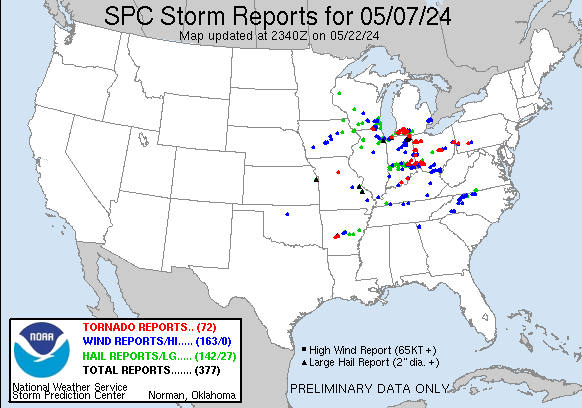
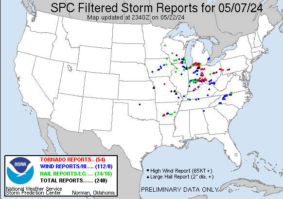
| Tornado Reports (CSV) (Raw Tornado CSV)(?) |
|---|
Time | | Location | County | State | Lat | Lon | Comments |
| 1843 | | 5 SW Huntsville | Randolph | MO | 3939 | 9260 | A tornado developed west of County Road 2160 in Randolph County during the early morning on May 7. It was initially weak ... damaging mainly trees along County Road 2180 (EAX) |
| 1905 | | 5 NNW Harvard | McHenry | IL | 4248 | 8866 | An EF-0 tornado began northwest of Capron in northern Boone County ... crossed into northwest McHenry County where a barn was destroyed ... then continued across the stat (LOT) |
| 1919 | | 1 SSW Darien | Walworth | WI | 4258 | 8872 | NWS storm survey confirmed a short lived EF-1 with 90 mph winds south of Darien. (MKX) |
| 1921 | | 2 SSW Walworth | Walworth | WI | 4251 | 8861 | NWS survey team confirmed an EF-0 with 80 mph winds across southern Walworth County from east of Sharon to west of Walworth. (MKX) |
| 1930 | | 3 WSW Michigan City | La Porte | IN | 4170 | 8693 | Public report of vehicle damage and tree limbs down across 6 acres of land on the Porter and La Porte County line. They said they had a sudden burst of wind followed by (IWX) |
| 2111 | | 1 NW Dowagiac | Cass | MI | 4200 | 8612 | An EF-1 tornado with maximum wind speeds of 95 mph occurred in the early evening of May 7th in Cass County ... MI. The tornado touched down in a field just north of the (IWX) |
| 2115 | | 3 NE Dowagiac | Cass | MI | 4202 | 8607 | Time estimated by radar. Facebook photo shows two center pivots flipped and damaged. At the intersection of Atwood Road and Gage Street. (IWX) |
| 2115 | | 4 NE Dowagiac | Cass | MI | 4203 | 8605 | Photos on Facebook show heavy tree damage near Twin Lakes ... just northeast of Dowagiac. Numerous trees of varying sizes snapped or uprooted. Time estimated by radar. (IWX) |
| 2141 | | 1 S Centreville | St. Joseph | MI | 4191 | 8553 | A tornado touched down in St. Joseph county on the south side of Centreville and then tracked northeast ... passing north of Colon ... crossing into Branch county near Ha (IWX) |
| 2142 | | Centreville | St. Joseph | MI | 4192 | 8553 | Video on Facebook shows tornado on the ground near Centreville MI. Time estimated from radar. (IWX) |
| 2143 | | 1 ESE Wasepi | St. Joseph | MI | 4194 | 8545 | Photo on Facebook of a large tornado on the ground between Centreville and Colon ... just north of Nottawa. Time estimated by radar. (IWX) |
| 2150 | | Colon | St. Joseph | MI | 4196 | 8532 | Damage to a home and trees snapped in Colon. Time estimated by TDS on radar. (IWX) |
| 2150 | | 3 ESE Mendon | St. Joseph | MI | 4199 | 8541 | (IWX) |
| 2152 | | Colon | St. Joseph | MI | 4196 | 8532 | Corrects previous tornado report from Colon. Trained spotter recorded video of a large cone tornado in Colon. (IWX) |
| 2153 | | 1 WNW Colon | St. Joseph | MI | 4197 | 8534 | Corrects previous tstm wnd dmg report from 1 WNW Colon. Reports of trees down and farm damage on Farrand Rd ... west of the roundabout. (IWX) |
| 2155 | | 4 WSW Portage | Kalamazoo | MI | 4219 | 8567 | The EF2 tornado touched down near the intersection of South 10th Street and West R Avenue and traveled east/northeast for around 11 miles until it lifted north of East (GRR) |
| 2200 | | Sherwood | Branch | MI | 4200 | 8524 | Video of debris being lofted in Sherwood. Time estimated by TDS on radar. Relayed by trained spotter. (IWX) |
| 2200 | | Mendon | St. Joseph | MI | 4201 | 8545 | Photo of a tornado in Mendon and time of occurrence relayed by broadcast media. Several photos from X/Twitter show a large tornado on the ground in and near Mendon MI. (IWX) |
| 2200 | | Leonidas | St. Joseph | MI | 4202 | 8535 | Tree damage reported in Leonidas by broadcast media. (IWX) |
| 2200 | | Leonidas | St. Joseph | MI | 4203 | 8535 | Tree damage near Glenwood. (IWX) |
| 2200 | | 2 W Portage | Kalamazoo | MI | 4220 | 8564 | Radar confirmed tornado. Time estimated via radar. (GRR) |
| 2207 | | 3 SW Union City | Branch | MI | 4203 | 8518 | A brief EF-1 tornado developed southwest of Union City ... MI as larger tornado dissipated to the northwest (rating on the larger tornado TBD). This tornado moved along (IWX) |
| 2211 | | 2 N Silver Lake | Steuben | IN | 4166 | 8507 | Numerous reports of a funnel cloud were received from west of Angola to north of Angola including in the area of Crooked and Loon lakes. Video footage confirms a brief (IWX) |
| 2222 | | 1 ESE Crooked Lake | Steuben | IN | 4168 | 8503 | Tornado near 200W just north of US 20. (IWX) |
| 2245 | | Colon | St. Joseph | MI | 4196 | 8532 | Trained spotter recorded video of a large cone tornado in Colon. Time given by spotter. (IWX) |
| 2318 | | 2 NE Portage | Kalamazoo | MI | 4222 | 8556 | Two trained spotters reporting a tornado touchdown in Portage. (GRR) |
| 2322 | | 4 SSE Comstock | Kalamazoo | MI | 4224 | 8549 | Time estimated by radar. (GRR) |
| 2331 | | 2 NE Waldron | Shelby | IN | 3947 | 8564 | Late report of EF0 tornado with peak wind 85 mph ... path length 0.78 miles. Max width 50 yards ... numerous uprooted trees and little home damage. Ended in Shelby Co. (IND) |
| 2345 | | 2 SW Moscow | Rush | IN | 3947 | 8559 | Late report of EF1 tornado with peak wind 110 mph ... path length 0.16 miles. Max width 30 yards ... metal barn hit but nearby silos untouched. (IND) |
| 2347 | | 3 SW New Salem | Rush | IN | 3951 | 8539 | Late report of EFU tornado with unknown peak wind ... path length 0.77 miles. Max width 30 yards ... clear video and drone IR image showed swirl yet no damage crossing fiel (IND) |
| 2350 | | 4 NNW Fort Recovery | Mercer | OH | 4046 | 8479 | EF2 tornado confirmed west of Coldwater in Mercer County Ohio. Maximum winds of 120 MPH. (ILN) |
| 0006 | | 1 SE Latty | Paulding | OH | 4108 | 8458 | Small to medium Limbs downed. (IWX) |
| 0008 | | 3 WSW Milton | Fayette | IN | 3977 | 8520 | NWS storm survey confirms an EF1 tornado with maximum estimated wind speeds of 90 MPH and a path length of 2.9 miles. Damage was primarily to trees along the path. (ILN) |
| 0008 | | 1 W Charloe | Paulding | OH | 4113 | 8446 | Van Wert County EMA relayed a photo of a tornado. Further investigation confirmed this damaged the house of a relative. Time estimated. (IWX) |
| 0009 | | 2 W Melrose | Paulding | OH | 4109 | 8446 | Corrects time of previous tornado report from 2 W Melrose. Additional review by emergency management and NWS found damage near Belmore ... so the time and path length of (IWX) |
| 0011 | | 2 W Melrose | Paulding | OH | 4109 | 8446 | Several reports of funnel clouds and a touchdown were received from near Latty east to south of Melrose and west of Oakwood. The most extensive damage occurred north of (IWX) |
| 0013 | | Oakwood | Paulding | OH | 4109 | 8439 | Report of tornado with visible soil lofted along Highway 613 west of Oakwood. (IWX) |
| 0016 | | 3 SSW Arthur | Paulding | OH | 4116 | 8439 | Emergency management sent drone footage which shows scoured dirt through a freshly plowed field along Road 166 between Road 191 and Ohio 66. The track terminates near a (IWX) |
| 0018 | | 1 E Milroy | Rush | IN | 3950 | 8545 | Touched down in a field east of Milroy. Nearby trees and power lines damaged. (IND) |
| 0020 | | 2 ESE Montezuma | Mercer | OH | 4047 | 8451 | EF2 tornado confirmed west of New Knoxville in Mercer and Auglaize counties in Ohio. Maximum winds of 130 MPH. (ILN) |
| 0024 | | 4 W Greenville | Darke | OH | 4010 | 8470 | EF1 tornado confirmed in and near Greenville in Darke County Ohio. Maximum winds of 110 MPH. (ILN) |
| 0025 | | 2 W Clarksburg | Decatur | IN | 3944 | 8539 | Late report of EF0 tornado with peak wind 81 mph ... path length 4.48 miles. Max width 100 yards ... utility poles downed on County Roads 500 East and 700 East. (IND) |
| 0036 | | 2 E Oakwood | Putnam | OH | 4109 | 8434 | Photo on X/Twitter between Melrose and Leipsic of a tornado on the ground. Time estimated by radar. (IWX) |
| 0040 | | Oakwood | Paulding | OH | 4109 | 8438 | Numerous photos on Facebook of a funnel cloud nearly on the ground between Melrose and Oakwood. Additional photos show the tornado on the ground near Oakwood. Fairly ce (IWX) |
| 0042 | | 1 WSW Sulphur Springs | Crawford | IN | 3821 | 8649 | A brief EF-0 tornado touched down about 1 mile SWS of Sulphur Springs ... IN where it grew to a max width of 80 yards and reached peak winds of 78 MPH. The tornado was o (LMK) |
| 0043 | | 1 WSW Sulphur Springs | Crawford | IN | 3821 | 8648 | The Crawford County Emergency Manager flew a drone and reported damage consistent with a tornado on the 8500 block of Old Union Church Road in Sulphur Springs. Damage i (LMK) |
| 0054 | | 2 S Belmore | Putnam | OH | 4112 | 8394 | A trained spotter reported a brief tornado touched down south of Belmore ... OH at 8:54 PM EDT May 7th. Videos confirm that a tornado did touch down in a field just east (IWX) |
| 0056 | | 4 NE Brookville | Franklin | IN | 3946 | 8496 | EF1 tornado confirmed northeast of Brookville in Franklin County Indiana. Maximum winds of 110 mph. (ILN) |
| 0056 | | 2 SE Belmore | Putnam | OH | 4113 | 8391 | Trained spotter observed a very brief tornado about 2 miles SSE of Belmore. A friend closer to the storm confirmed it visually on the ground for a few seconds. (IWX) |
| 0120 | | 4 SSE Oxford | Butler | OH | 3945 | 8473 | EF1 tornado confirmed south-southeast of Oxford ... Ohio. Maximum winds of 110 mph. (ILN) |
| 0123 | | 1 ENE Bennettsville | Clark | IN | 3844 | 8578 | The NWS in Louisville conducted a storm survey and found EF0 85 mph wind damage. The tornado was 0.41 miles long with a width of 60 yards. For more information ... pleas (LMK) |
| 0157 | | 2 N Monroe | Butler | OH | 3948 | 8434 | EF0 tornado confirmed in Middletown in Butler County Ohio. Maximum winds of 80 mph. (ILN) |
| 0205 | | 3 SW Lebanon | Warren | OH | 3940 | 8425 | NWS storm survey confirms an EF0 tornado with maximum estimated wind speeds of 80 MPH and a path length of 1/3 mile. Damage primarily to trees along the path. (ILN) |
| 0208 | | South Lebanon | Warren | OH | 3937 | 8421 | Updated LSR for tornado previously confirmed as 2NE South Lebanon ... increasing the track length. Maximum winds remain at 90 mph. (ILN) |
| 0210 | | 2 NE South Lebanon | Warren | OH | 3939 | 8419 | EF-1 Tornado confirmed 2NE South Lebanon in Warren County Ohio. Max winds of 90 mph. (ILN) |
| 0214 | | 2 E Lebanon | Warren | OH | 3943 | 8418 | EF-0 Tornado confirmed 2E Lebanon in Warren County Ohio. Max winds of 65 mph. (ILN) |
| 0215 | | Morrow | Warren | OH | 3935 | 8413 | NWS storm survey confirms an EF1 tornado with maximum estimated wind speeds of 95 MPH and a path length of 2.7 miles. Damage primarily to trees and outbuildings along p (ILN) |
| 0215 | | 1 ENE Morrow | Warren | OH | 3936 | 8412 | EF1 tornado confirmed near Morrow in Warren County Ohio. Maximum winds of 95 mph. (ILN) |
| 0218 | | 3 NE Morrow | Warren | OH | 3938 | 8409 | EF0 tornado confirmed northeast of Morrow in Warren County Ohio. Maximum winds of 80 mph. (ILN) |
| 0227 | | 2 N Blanchester | Clinton | OH | 3931 | 8399 | EF0 tornado confirmed north of Blanchester in Clinton County Ohio. Maximum winds of 85 mph. (ILN) |
| 0227 | | 3 W Clarksville | Warren | OH | 3939 | 8403 | EF0 tornado confirmed west of Clarksville in Warren County Ohio. Maximum winds of 80 mph. (ILN) |
| 0349 | | 4 E Saint Louisville | Licking | OH | 4017 | 8234 | NWS storm survey confirms an EF0 tornado with maximum estimated wind speeds of 75 mph and a path length of 3.1 miles. Damage primarily to trees and outbuildings. (ILN) |
| 0403 | | 3 N Frazeysburg | Muskingum | OH | 4016 | 8212 | NWS Storm Survey Team found an EF1 tornado with maximum gusts of 100mph that occurred early Wednesday morning north of Frazeysburg. Additional details will be found in (PBZ) |
| 0418 | | 3 SE Wakatomika | Coshocton | OH | 4018 | 8201 | NWS Storm Survey team found an EF1 tornado with maximum gusts of 105mph that occurred early Wednesday morning west of Conesville. Additional details will be found in a (PBZ) |
| 0500 | | Irondale | Jefferson | OH | 4057 | 8073 | Radar confirmed tornado. Damage to trees and homes near County Road 55. Time estimated on radar. (PBZ) |
| 0513 | | Fairhaven | Hancock | WV | 4056 | 8056 | *** 1 Inj *** One woman was injured by broken glass along International Drive and taken to the hospital. (PBZ) |
| 0515 | | 3 S Chester | Hancock | WV | 4057 | 8055 | Strong tornado damage (EF2+) found in Fairhaven WV area. Significant damage to homes ... barns ... and trees. TDS on KPBZ WSR-88D seen at 0514z and 0516z volume scans in (PBZ) |
| 0530 | | 2 WSW Pettyview | Garland | AR | 3439 | 9320 | ***Delayed Report*** A storm survey determined that an EF2 tornado occurred across portions of Garland County. Peak winds were estimated to be 120 mph ... max width was (LZK) |
| 0549 | | 2 ENE Lake Hamilton | Garland | AR | 3444 | 9305 | Video from public showing tornado over Lake Hamilton ... with power flashes. Debris signature on radar shortly afterwards. (LZK) |
| 0549 | | 1 ESE Coraopolis Height | Allegheny | PA | 4046 | 8020 | **CORRECTION TO DATE** NWS Storm Survey Team found an EF1 tornado along Aten Road. Details will be found in a Public Information Statement. (PBZ) |
| 0600 | | 4 NE Red Oak | Garland | AR | 3447 | 9298 | Image of damage from possible tornado. (LZK) |
| 0709 | | 3 NNE Millbank | Westmoreland | PA | 4031 | 7925 | NWS Storm Survey Team found an EF1 tornado with maximum gusts of 95mph to 100mph. Additional details will be found in a future Public Information Statement. (PBZ) |
| Hail Reports (CSV) (Raw Hail CSV)(?) |
|---|
Time | Size | Location | County | State | Lat | Lon | Comments |
| 1724 | 100 | 4 NW Tampico | Whiteside | IL | 4169 | 8982 | (DVN) |
| 1733 | 100 | Grimes Addition | Whiteside | IL | 4180 | 8975 | (DVN) |
| 1843 | 100 | Channahon | Grundy | IL | 4141 | 8825 | Photos shared on social media showing quarter size hail in Channahon. Time estimated from radar. (LOT) |
| 1852 | 100 | Merrionette Park | Cook | IL | 4168 | 8770 | (LOT) |
| 1853 | 100 | Beverly - Chicago | Cook | IL | 4171 | 8767 | (LOT) |
| 1856 | 100 | 1 SW Evergreen Park | Cook | IL | 4171 | 8772 | Report from mPING: Quarter (1.00 in.). (LOT) |
| 1907 | 100 | 3 NE New Lenox | Will | IL | 4154 | 8794 | Report from mPING: Quarter (1.00 in.). (LOT) |
| 1912 | 150 | 2 NW Mokena | Will | IL | 4155 | 8791 | Photo shared on social media showing hail that fell in Mokena. The largest hailstone was approximately 1.5 inches in diameter with most other hailstones being under 1 i (LOT) |
| 1912 | 100 | Homer Glen | Will | IL | 4160 | 8794 | Corrects time on previous hail report from Homer Glen. (LOT) |
| 1913 | 100 | Orland Park | Cook | IL | 4156 | 8790 | 179th near Southwest Highway. (LOT) |
| 1916 | 150 | Orland Park | Cook | IL | 4162 | 8785 | (LOT) |
| 1917 | 100 | 1 E Orland Hills | Cook | IL | 4159 | 8783 | Report from mPING: Quarter (1.00 in.). (LOT) |
| 1917 | 100 | 2 N Tinley Park | Cook | IL | 4160 | 8779 | Orland Park/Tinley Park - 159th and Harlem Ave. (LOT) |
| 1918 | 175 | 1 N Tinley Park | Cook | IL | 4159 | 8780 | (LOT) |
| 1918 | 100 | 1 W Pewaukee | Waukesha | WI | 4309 | 8826 | Report from mPING: Quarter (1.00 in.). (MKX) |
| 1920 | 100 | Tinley Park | Cook | IL | 4157 | 8780 | (LOT) |
| 1920 | 200 | 2 N Tinley Park | Cook | IL | 4160 | 8779 | Corrects time on previous hail report from 2 N Tinley Park. (LOT) |
| 1920 | 125 | Orland Park | Cook | IL | 4162 | 8785 | (LOT) |
| 1920 | 125 | Crestwood | Cook | IL | 4165 | 8775 | (LOT) |
| 1920 | 125 | Alsip | Cook | IL | 4167 | 8774 | (LOT) |
| 1920 | 100 | 1 W Palos Park | Cook | IL | 4167 | 8785 | (LOT) |
| 1922 | 100 | Homer Glen | Will | IL | 4160 | 8794 | (LOT) |
| 1922 | 150 | Palos Heights | Cook | IL | 4167 | 8780 | (LOT) |
| 1923 | 125 | Crestwood | Cook | IL | 4165 | 8775 | Corrects time on previous hail report from Crestwood. (LOT) |
| 1923 | 150 | 1 W Alsip | Cook | IL | 4167 | 8776 | Time estimated by radar. Relayed via mping. (LOT) |
| 1923 | 100 | Palos Hills | Cook | IL | 4169 | 8782 | Report from mPING: Quarter (1.00 in.). (LOT) |
| 1923 | 100 | Worth | Cook | IL | 4169 | 8780 | Report from mPING: Quarter (1.00 in.). (LOT) |
| 1924 | 100 | Sussex | Waukesha | WI | 4314 | 8822 | (MKX) |
| 1925 | 125 | 1 NW Oak Forest | Cook | IL | 4161 | 8775 | Report from mPING: Half Dollar (1.25 in.). (LOT) |
| 1925 | 125 | Alsip | Cook | IL | 4167 | 8774 | Corrects time on previous hail report from Alsip. (LOT) |
| 1926 | 100 | 1 W Oak Lawn | Cook | IL | 4172 | 8777 | Report from mPING: Quarter (1.00 in.). (LOT) |
| 1927 | 100 | Hometown | Cook | IL | 4173 | 8773 | Relayed via mping. Time estimated via radar. (LOT) |
| 1930 | 200 | 2 N Tinley Park | Cook | IL | 4160 | 8779 | (LOT) |
| 1930 | 100 | 1 SW Auburn-Gresham | Cook | IL | 4174 | 8767 | Corrects time on previous hail report from 1 SW Auburn-Gresham. (LOT) |
| 1938 | 100 | 1 SW Auburn-Gresham | Cook | IL | 4174 | 8767 | (LOT) |
| 1949 | 150 | 2 SE Hobart | Lake | IN | 4151 | 8723 | (LOT) |
| 1952 | 100 | 1 S Hobart | Lake | IN | 4152 | 8726 | Time estimated by radar. Relayed via mping. (LOT) |
| 1957 | 100 | Portage | Porter | IN | 4156 | 8718 | Photo shared on social media showing quarter size hail in Portage. Time estimated from radar. (LOT) |
| 2005 | 125 | 2 NNE Porter | Porter | IN | 4164 | 8706 | (LOT) |
| 2015 | 350 | Michigan City | La Porte | IN | 4172 | 8688 | (IWX) |
| 2016 | 125 | Town of Pines | Porter | IN | 4168 | 8696 | (LOT) |
| 2020 | 200 | 1 S Michigan City | La Porte | IN | 4170 | 8688 | (IWX) |
| 2020 | 300 | Michigan City | La Porte | IN | 4171 | 8688 | Corrects previous hail report from Michigan City. Hail damage to vehicles in downtown Michigan City. Public report of 2 to 3.0 inch hailstones. (IWX) |
| 2022 | 350 | Michigan City | La Porte | IN | 4172 | 8688 | Corrects previous hail report from Michigan City. (IWX) |
| 2022 | 175 | 1 NW Michigan City | La Porte | IN | 4172 | 8689 | (IWX) |
| 2023 | 250 | Michigan City | La Porte | IN | 4172 | 8688 | (IWX) |
| 2026 | 250 | 1 S Long Beach | La Porte | IN | 4174 | 8686 | Reported by Trained Spotter. (IWX) |
| 2028 | 100 | 1 W Michiana Shores | La Porte | IN | 4175 | 8683 | (IWX) |
| 2030 | 100 | 1 S Oak Creek | Milwaukee | WI | 4287 | 8790 | Report from mPING: Quarter (1.00 in.). (MKX) |
| 2030 | 100 | 1 S South Milwaukee | Milwaukee | WI | 4289 | 8786 | (MKX) |
| 2030 | 100 | South Milwaukee | Milwaukee | WI | 4291 | 8786 | Photos of measured 1in hail from spotter on Facebook. (MKX) |
| 2031 | 150 | Oak Creek | Milwaukee | WI | 4289 | 8791 | Picture with measurement shown on WISN 12. (MKX) |
| 2032 | 125 | 1 E Oak Creek | Milwaukee | WI | 4287 | 8787 | Report from mPING: Half Dollar (1.25 in.). (MKX) |
| 2035 | 100 | 2 SE West Terre Haute | Vigo | IN | 3944 | 8743 | Report from mPING: Quarter (1.00 in.). (IND) |
| 2036 | 100 | 2 S Oak Creek | Milwaukee | WI | 4285 | 8790 | Report from mPING: Quarter (1.00 in.). (MKX) |
| 2038 | 100 | New Buffalo | Berrien | MI | 4179 | 8674 | (IWX) |
| 2038 | 100 | 2 SW Pleasant Prairie | Kenosha | WI | 4252 | 8795 | Report from mPING: Quarter (1.00 in.). (MKX) |
| 2040 | 100 | Terre Haute | Vigo | IN | 3947 | 8738 | (IND) |
| 2042 | 100 | 1 W South Milwaukee | Milwaukee | WI | 4291 | 8787 | Report from mPING: Quarter (1.00 in.). (MKX) |
| 2056 | 100 | 2 N Staunton | Clay | IN | 3951 | 8719 | (IND) |
| 2100 | 300 | Michigan City | La Porte | IN | 4171 | 8688 | Hail damage to vehicles in downtown Michigan City. Public report of 2 to 2.5 inch hailstones. (IWX) |
| 2100 | 100 | Berrien Springs | Berrien | MI | 4195 | 8634 | Delayed report. (IWX) |
| 2108 | 100 | 3 ESE Reidsville | Rockingham | NC | 3633 | 7962 | (RNK) |
| 2108 | 100 | 3 W Reelsville | Putnam | IN | 3954 | 8701 | Report from mPING. (IND) |
| 2109 | 100 | 1 N Dewey Lake | Cass | MI | 4207 | 8619 | Corrects previous hail report from 1 N Dewey Lake. Report from mPING: Quarter (1.00 in.). (IWX) |
| 2109 | 100 | 1 WNW Independence | Buchanan | IA | 4247 | 9191 | (DVN) |
| 2110 | 150 | Reelsville | Putnam | IN | 3955 | 8697 | (IND) |
| 2111 | 100 | 3 S Wentworth | Rockingham | NC | 3636 | 7976 | (RNK) |
| 2113 | 100 | 2 N Independence | Buchanan | IA | 4250 | 9189 | Spotter measured quarter size hail at this location. (DVN) |
| 2122 | 175 | 3 SE Cumberland | Barron | WI | 4550 | 9197 | (MPX) |
| 2130 | 150 | Three Rivers | St. Joseph | MI | 4194 | 8563 | Delayed report. Time estimated by radar. (IWX) |
| 2140 | 125 | 2 NNE Belle Union | Putnam | IN | 3960 | 8668 | (IND) |
| 2150 | 100 | 1 N Dewey Lake | Cass | MI | 4207 | 8619 | Report from mPING: Quarter (1.00 in.). (IWX) |
| 2156 | 175 | 2 NNW Fairfax | St. Joseph | MI | 4198 | 8538 | (IWX) |
| 2200 | 250 | Leonidas | St. Joseph | MI | 4202 | 8535 | Pictures shared of up to tennis ball size hail. (IWX) |
| 2201 | 200 | 2 NW Portage | Kalamazoo | MI | 4222 | 8562 | (GRR) |
| 2208 | 400 | Leonidas | St. Joseph | MI | 4202 | 8535 | Photo on X/Twitter shows a 4 inch diameter hailstone!. (IWX) |
| 2210 | 100 | 8 NE Decorah | Winneshiek | IA | 4339 | 9168 | Social media report with picture. (ARX) |
| 2211 | 400 | Union City | Branch | MI | 4207 | 8514 | Picture shared on twitter of hail stone measuring upwards of 4 inches. (IWX) |
| 2214 | 100 | 1 S North Manchester | Wabash | IN | 4099 | 8577 | Corrects time for previous hail report from 1 S North Manchester. (IWX) |
| 2217 | 150 | Coldwater | Branch | MI | 4194 | 8500 | (IWX) |
| 2222 | 100 | 1 SSE Jonesboro | Grant | IN | 4046 | 8562 | Also recorded a 51 mph gust on an anemometer. (IWX) |
| 2227 | 100 | 1 S North Manchester | Wabash | IN | 4099 | 8577 | (IWX) |
| 2230 | 100 | 2 W Pimento | Vigo | IN | 3930 | 8743 | Winds gusting to estimated 45 mph. (IND) |
| 2230 | 100 | 2 E Warrens | Monroe | WI | 4413 | 9046 | Variable hail sizes up to 1 inch in diameter. Stripped leaves and branches off trees. (ARX) |
| 2232 | 175 | 2 ESE Fairview | Surry | NC | 3632 | 8069 | (RNK) |
| 2235 | 175 | 1 SE Dobson | Surry | NC | 3638 | 8071 | (RNK) |
| 2239 | 100 | 3 N Trafalgar | Johnson | IN | 3946 | 8616 | Along SR 135. (IND) |
| 2250 | 300 | Kendallville | Noble | IN | 4144 | 8527 | (IWX) |
| 2253 | 100 | Avilla | Noble | IN | 4136 | 8524 | Hail occurred between 6:50 and 6:55 PM. (IWX) |
| 2254 | 175 | 2 W Lisbon | Noble | IN | 4141 | 8529 | (IWX) |
| 2255 | 175 | 2 NW Brooklyn | Morgan | IN | 3956 | 8640 | (IND) |
| 2255 | 300 | Kendallville | Noble | IN | 4144 | 8526 | Damage to cars ... windows ... and siding on homes in Kendallville due to hailstones up to 3 inches in diameter. (IWX) |
| 2257 | 175 | Corunna | De Kalb | IN | 4144 | 8514 | Time estimated by radar. (IWX) |
| 2257 | 300 | Kendallville | Noble | IN | 4144 | 8527 | Corrects previous hail report from Kendallville. (IWX) |
| 2300 | 100 | 1 N Hudson | Steuben | IN | 4154 | 8508 | (IWX) |
| 2305 | 300 | Corunna | De Kalb | IN | 4144 | 8514 | Hail damage reported in Corunna to car ... siding ... and roofs. Hailstones up to 3 inches in diameter fell. Time estimated by radar. (IWX) |
| 2305 | 300 | Kendallville | Noble | IN | 4145 | 8526 | Several 3 inch hailstones per Facebook reports. (IWX) |
| 2309 | 300 | Hudson | Steuben | IN | 4153 | 8508 | Time estimated by radar. (IWX) |
| 2309 | 250 | 1 NE Hudson | Steuben | IN | 4154 | 8507 | Time estimated from radar. (IWX) |
| 2309 | 100 | 1 N Hudson | Steuben | IN | 4154 | 8508 | Corrects previous hail report from 1 N Hudson. (IWX) |
| 2310 | 100 | 3 S Capella | Stokes | NC | 3632 | 8032 | A business on Denny Road reported hail slightly larger than the size of a quarter. (RNK) |
| 2312 | 175 | Pleasant Lake | Steuben | IN | 4158 | 8502 | (IWX) |
| 2315 | 150 | 1 SW Angola | Steuben | IN | 4163 | 8501 | Delayed report relayed by broadcast media. Ping pong ball hail near Trine University in Angola. Time estimated by radar. (IWX) |
| 2315 | 175 | 1 S Angola | Steuben | IN | 4163 | 8500 | (IWX) |
| 2315 | 100 | Lore | Dubuque | IA | 4252 | 9080 | Spotter reported hail went from nickel size to now quarter size. (DVN) |
| 2318 | 100 | 2 W Galva | Henry | IL | 4117 | 9008 | Corrects previous hail report from 2 W Galva. Spotter reported lots of pea to dime size hail with a few up to quarters. Report relayed by EM. (DVN) |
| 2318 | 300 | Ashley | De Kalb | IN | 4153 | 8507 | Facebook photo of several 3 inch hailstones. (IWX) |
| 2321 | 100 | 4 NW Westover Hills | Pittsylvania | VA | 3665 | 7950 | (RNK) |
| 2322 | 100 | New Whiteland | Johnson | IN | 3956 | 8609 | (IND) |
| 2322 | 100 | 4 E Southport | Marion | IN | 3965 | 8604 | Report from mPING: Quarter (1.00 in.). (IND) |
| 2322 | 350 | Ashley | De Kalb | IN | 4153 | 8507 | (IWX) |
| 2325 | 350 | Kendallville | Noble | IN | 4145 | 8526 | Delayed report. Report from mPING: Baseball (3.50 in.). (IWX) |
| 2327 | 100 | 4 E Southport | Marion | IN | 3965 | 8604 | Report from mPING: Quarter (1.00 in.). (IND) |
| 2328 | 100 | 1 N Dubuque | Dubuque | IA | 4252 | 9069 | Trained Spotter reported quarter size hail at the Amazon facility in Dubuque. (DVN) |
| 2332 | 100 | 2 N Danville City | City of Danville | VA | 3661 | 7941 | (RNK) |
| 2333 | 100 | 1 SW Dodgeville | Iowa | WI | 4295 | 9014 | Some Quarter size ... most nickel size. Also reported by Emergency Manager. (MKX) |
| 2343 | 175 | Hillsdale | Hillsdale | MI | 4193 | 8464 | Time estimated from radar. (IWX) |
| 2348 | 100 | 1 SW Oxford | Marquette | WI | 4377 | 8957 | Dime to Quarter size hail. (MKX) |
| 2356 | 100 | 3 S Marietta | Shelby | IN | 3939 | 8590 | Report from mPING: Quarter (1.00 in.). (IND) |
| 2358 | 100 | Manilla | Rush | IN | 3957 | 8562 | (IND) |
| 0000 | 100 | 1 W Mount Horeb | Dane | WI | 4301 | 8974 | Report from mPING: Quarter (1.00 in.). (MKX) |
| 0015 | 100 | 3 SSW Paragon | Morgan | IN | 3935 | 8659 | Third hail producing storm following pea hail in first two rounds. (IND) |
| 0019 | 100 | 2 S Greenville | Darke | OH | 4008 | 8463 | Mostly pea-sized hail ... but a few stones as large as a quarter mixed in. (ILN) |
| 0031 | 100 | 1 E Saint Paul | Decatur | IN | 3943 | 8561 | (IND) |
| 0127 | 100 | 3 SE Greensburg | Decatur | IN | 3931 | 8544 | (IND) |
| 0138 | 100 | Mukwonago | Waukesha | WI | 4287 | 8834 | Public report of nickel to quarter size hail in Mukwonago. Time estimated via radar. (MKX) |
| 0145 | 100 | 1 S Mukwonago | Waukesha | WI | 4285 | 8834 | Report from mPING: Quarter (1.00 in.). (MKX) |
| 0209 | 100 | 1 NW Cedarburg | Ozaukee | WI | 4331 | 8800 | Report from mPING: Quarter (1.00 in.). (MKX) |
| 0213 | 100 | Bellbrook | Greene | OH | 3964 | 8408 | Report from mPING: Quarter (1.00 in.). (ILN) |
| 0250 | 175 | 1 W Ellettsville | Monroe | IN | 3923 | 8663 | (IND) |
| 0254 | 100 | 2 W Westerville | Delaware | OH | 4014 | 8296 | Report from mPING: Quarter (1.00 in.). (ILN) |
| 0542 | 275 | 3 SW Hillsboro | Jefferson | MO | 3820 | 9062 | Time estimated from radar. (LSX) |
| 0552 | 200 | 1 NNE Hot Springs | Garland | AR | 3451 | 9304 | (LZK) |
| 0727 | 125 | Kensington Place | Pulaski | AR | 3473 | 9239 | (LZK) |
| 0818 | 150 | Blakemore | Lonoke | AR | 3460 | 9188 | (LZK) |
| 0914 | 100 | 2 N Stuttgart | Arkansas | AR | 3452 | 9155 | (LZK) |
| 1052 | 100 | 5 ENE Moro | Lee | AR | 3483 | 9091 | Quarter-sized hail observed in the Holub Crossing area. (MEG) |
| 1148 | 200 | 4 E Farmington | St. Francois | MO | 3778 | 9035 | Social media report with photo. Time/location approximate ... augmented using radar. (LSX) |
| 1150 | 100 | 3 S Aurora | Calloway | KY | 3673 | 8814 | Report from mPING of Quarter (1.00 in.) hail. (PAH) |
| 1154 | 200 | 2 NNW Olathe | Johnson | KS | 3891 | 9483 | Mostly quarters but one hail stone was 2 inches in diameter. (EAX) |
| 1155 | 125 | Olathe | Johnson | KS | 3889 | 9482 | Report from mPING: Half Dollar (1.25 in.). (EAX) |
| Wind Reports (CSV) (Raw Wind CSV)(?) |
|---|
Time | Speed | Location | County | State | Lat | Lon | Comments |
| 1200 | UNK | 1 S Gridley | McLean | IL | 4073 | 8888 | Roof blown off a farm shop on south edge of Gridley. (ILX) |
| 1245 | UNK | Douglas | Garfield | OK | 3626 | 9767 | Damaged power pole. Facebook report with picture. Time est. from radar. (OUN) |
| 1321 | UNK | 5 NNW Millville | Butler | OH | 3945 | 8468 | Large tree branches thrown and several uprooted. Possible tornado. Time estimated. (ILN) |
| 1549 | UNK | 6 N Hanover | Licking | OH | 4017 | 8229 | Multiple trees down ... one of which causing damage to back porch of residence near intersection of Rain Rock Road and Rocky Ford Road. (ILN) |
| 1559 | UNK | 1 WSW Bourbon | Crawford | MO | 3815 | 9126 | Delayed report. Tree down over roadway at the 1000 and 1500 blocks of Old Springfield Road. Time estimated from radar. (LSX) |
| 1720 | UNK | 1 NE Norwood | Hamilton | OH | 3917 | 8444 | Large Tree and wires down near Ridgeland Place and Montgomery Road. (ILN) |
| 1917 | UNK | 6 NNW Harvard | McHenry | IL | 4249 | 8868 | Corrects previous tstm wnd dmg report from 6 NNW Harvard. Barn collapse. (LOT) |
| 1919 | UNK | 1 NW Oak Forest | Cook | IL | 4161 | 8776 | Large tree downed on fence ... photo relayed via service account email. Time estimated by radar. (LOT) |
| 1920 | UNK | Alsip | Cook | IL | 4167 | 8774 | reports of minor gutter damage to homes. (LOT) |
| 1923 | UNK | Walworth | Walworth | WI | 4253 | 8860 | Large tree branch down and leaning power pole near intersection of Hwy 67 and County Rd B. (MKX) |
| 1924 | UNK | Walworth | Walworth | WI | 4253 | 8860 | Semi rolled over near intersection of Hwy 67 and US 14. Power lines down in area of Walworth and Fontana. Time estimated from radar. (MKX) |
| 1929 | UNK | 1 NNE Roseland - Chicag | Cook | IL | 4172 | 8762 | Multiple reports of tree damage across the south side of Chicago. The damage appeared to be most concentrated in the Washington Heights ... Roseland ... Chatham ... Avalon (LOT) |
| 1930 | UNK | 3 WSW Michigan City | La Porte | IN | 4170 | 8693 | Corrects previous tornado report from 3 WSW Michigan City. A storm survey of the area near Town of Pines found vehicle and tree damage consistent with a microburst as w (IWX) |
| 1935 | UNK | 6 NNW Harvard | McHenry | IL | 4249 | 8868 | Barn collapse. (LOT) |
| 1938 | UNK | 1 W Como | Walworth | WI | 4261 | 8852 | Photos and video relayed by amateur radio showing snapped trees and tree limbs near Prestwick Drive in the Geneva National Golf Community. Time estimated via radar. (MKX) |
| 1945 | UNK | 2 S Hebron | McHenry | IL | 4244 | 8844 | Large branches down ... road impassable by cars on Rt 47 and Vander Karr. (LOT) |
| 2000 | UNK | 2 ENE State Road | Surry | NC | 3633 | 8084 | Tree down blocking both lanes at Pat Nixon Road and Adams Ridge Road. (RNK) |
| 2005 | UNK | 2 NNE Porter | Porter | IN | 4164 | 8706 | Numerous trees reported down in area. (LOT) |
| 2006 | UNK | 1 NNE Porter | Porter | IN | 4163 | 8707 | Trees down. (LOT) |
| 2007 | UNK | 1 SW Porter | Porter | IN | 4161 | 8708 | Large trees snapped near base. (LOT) |
| 2011 | UNK | 2 NNE Porter | Porter | IN | 4164 | 8706 | CR50 and US 20 Tree down on road. (LOT) |
| 2016 | UNK | Town of Pines | Porter | IN | 4168 | 8695 | An NWS storm survey found that tree and vehicle damage in and near the Town of Pines area was caused by a microburst and wind-driven large hail. (LOT) |
| 2019 | UNK | 3 WSW Michigan City | La Porte | IN | 4170 | 8693 | Corrects previous tstm wnd dmg report from 3 WSW Michigan City. Corrects previous tornado report from 3 WSW Michigan City. A storm survey of the area near Town of Pines (IWX) |
| 2036 | UNK | 4 S Shingle Hollow | Rutherford | NC | 3541 | 8207 | Trees blown down on Clark Rd. Time estimated from radar. (GSP) |
| 2048 | UNK | 2 WSW Forest City | Rutherford | NC | 3533 | 8190 | Trees blown down on Piney Ridge Rd. Time estimated from radar. (GSP) |
| 2054 | UNK | 2 WNW Alexander Mills | Rutherford | NC | 3531 | 8188 | Trees blown down on Bethany Church Rd. Time estimated from radar. (GSP) |
| 2100 | 60 | Brazil | Clay | IN | 3953 | 8712 | Wind briefly reaching 50-60 mph amid torrential rain with no hail. (IND) |
| 2113 | UNK | 1 ENE Reidsville | Rockingham | NC | 3635 | 7965 | Large limbs down across yard. (RNK) |
| 2124 | UNK | 1 S Wilkesboro | Wilkes | NC | 3612 | 8116 | One tree blown down by thunderstorm winds north of Moravian Falls. (RNK) |
| 2129 | UNK | 1 SSW Fairplains | Wilkes | NC | 3618 | 8116 | At least one tree blown down near N. Wilkesboro. (RNK) |
| 2132 | UNK | 2 S Decatur | Van Buren | MI | 4208 | 8597 | Chaser provided photos of several trees uprooted and snapped just south of Decatur. Time is estimated by radar. (GRR) |
| 2140 | UNK | 3 NW Windy Gap | Wilkes | NC | 3615 | 8102 | One tree blown down by thunderstorm winds on U.S. Highway 421 South. (RNK) |
| 2150 | UNK | 3 SSW Chili | Miami | IN | 4083 | 8605 | Delayed report. Tree damage near intersection of 400N/100E. (IWX) |
| 2153 | UNK | 1 WNW Colon | St. Joseph | MI | 4197 | 8534 | Reports of trees down and farm damage on Farrand Rd ... west of the roundabout. (IWX) |
| 2155 | UNK | 4 W Portage | Kalamazoo | MI | 4219 | 8567 | Large trees down ... power lines down ... shingles scattered around. Possible tornado. Time estimated based on radar. (GRR) |
| 2156 | UNK | 1 SE Ellendale | Alexander | NC | 3592 | 8127 | A couple trees blown down on Willie McLeod Rd. Time estimated from radar. (GSP) |
| 2205 | UNK | 1 NE Portage | Kalamazoo | MI | 4222 | 8557 | *** 1 INJ *** A lady taking cover from possible tornado was hit by debris as she got out of her car. Her leg is broken. (GRR) |
| 2206 | UNK | 2 ENE Portage | Kalamazoo | MI | 4222 | 8556 | Fed Ex building damaged. Possible tornado. (GRR) |
| 2206 | UNK | 1 NE Portage | Kalamazoo | MI | 4222 | 8557 | Estimated 3 foot diameter trees down. Estimated time via radar. (GRR) |
| 2211 | UNK | 2 NW Crutchfield | Surry | NC | 3630 | 8074 | Tree down in the 700 block of West Mount Herman Church Road ... northeast of Elkin. Time estaimted from radar data. (RNK) |
| 2212 | UNK | 2 E Laketon | Wabash | IN | 4098 | 8579 | Report of 3 damaged residences ... roof off one of them ... as well uprooted trees and power lines down. On state route 13 between 1000 and 1100 north. (IWX) |
| 2214 | UNK | Tekonsha | Calhoun | MI | 4209 | 8499 | Numerous trees and wires down in Tekonsha. Time is estimated via radar. (GRR) |
| 2215 | UNK | North Manchester | Wabash | IN | 4101 | 8577 | Large tree branches snapped in North Manchester (estimated 6-12 inches in diameter). (IWX) |
| 2215 | UNK | North Manchester | Wabash | IN | 4101 | 8578 | Video on Facebook shows powerlines snapped on State Road 13. Also a report half a mile down the road of a barn destroyed. (IWX) |
| 2220 | UNK | Fairmount | Grant | IN | 4042 | 8565 | Delayed report. Report of a few trees down and a few large limbs. Time estimated from radar. (IWX) |
| 2222 | UNK | Fairmount | Grant | IN | 4042 | 8565 | Powerlines down. Some roads are being blocked off. (IWX) |
| 2225 | UNK | 1 SW Logansport | Cass | IN | 4074 | 8637 | Large tree limbs down. Time estimated by radar. (IWX) |
| 2226 | UNK | 4 W Greenwood | Johnson | IN | 3962 | 8618 | Thunderstorm winds downed a few 12 inch diameter trees along Fairview Road at Leaning Tree Road and Peterman Road. Some fences down and some roofs damaged. Time estimat (IND) |
| 2226 | UNK | 2 E Goblesville | Huntington | IN | 4100 | 8547 | Minor limb damage. (IWX) |
| 2227 | UNK | South Whitley | Whitley | IN | 4109 | 8563 | Barn downed in South Whitley. Unknown how strong wind speeds were. Time estimated by radar. (IWX) |
| 2234 | UNK | 1 W Columbia City | Whitley | IN | 4116 | 8550 | Time estimated by radar. Large tree snapped in Columbia City ... Estimated 12 to 18 inches in diameter. (IWX) |
| 2235 | UNK | Columbia City | Whitley | IN | 4116 | 8548 | Time estimated by radar. Photo on Facebook of a large tree snapped at the base in Columbia City. Estimated to be 1 to 2 feet in diameter. (IWX) |
| 2235 | UNK | Larwill | Whitley | IN | 4118 | 8562 | Photos on Facebook shows several barns damaged in Larwill. Time estimated from radar. (IWX) |
| 2237 | UNK | 1 NNW Siloam | Surry | NC | 3629 | 8057 | Tree and power line down across both lanes of the roadway in the 6900 block of Siloam Road near Siloam Baptist Church. (RNK) |
| 2242 | UNK | 3 E Level Cross | Surry | NC | 3635 | 8058 | Tree down in the 290 block of Siloam Church Road ... north of the city of Siloam. Time estimated from radar data. (RNK) |
| 2252 | UNK | 3 N Green Center | Noble | IN | 4135 | 8536 | Delayed report and time estimated by radar. Several healthy tree branches around 12in in diameter broken and a couple more uprooted just west of N 350 E. Also hail dama (IWX) |
| 2255 | UNK | Albion | Noble | IN | 4140 | 8542 | Time estimated by radar. Large tree ... estimated 1 to 2 feet in diameter ... uprooted in Albion. (IWX) |
| 2259 | UNK | 2 SE Pilot Mountain | Stokes | NC | 3636 | 8045 | Tree down blocking one lane of Old Winston Road. (RNK) |
| 2303 | UNK | Natural Bridge State Pa | Powell | KY | 3777 | 8368 | Trees down at Natural Bridge State Park near the Campground and Hoedown Island. The event time is radar estimated. (JKL) |
| 2306 | UNK | 2 E Scotts | Iredell | NC | 3584 | 8098 | Report of a couple trees blown down at Scotts Creek Road near Stevenson Farm Rd. Time estimated from radar. (GSP) |
| 2313 | UNK | 3 W Portage | Kalamazoo | MI | 4220 | 8564 | Multiple trees and power lines down across road. Possible tornado. (GRR) |
| 2326 | UNK | Grimes | Polk | IA | 4169 | 9379 | Large tree branches down. Image posted on social media. Time estimated from radar. (DMX) |
| 2331 | 59 | 2 WNW Atlantic | Cass | IA | 4141 | 9505 | Time estimated. (DMX) |
| 2332 | UNK | 3 S Polk City | Polk | IA | 4174 | 9372 | Snapped tree branches ... roughly 4 to 5 inches. Time estimated from radar. (DMX) |
| 2335 | UNK | 1 NE Polk City | Polk | IA | 4178 | 9371 | Large tree down in Polk City. Time estimated from radar. (DMX) |
| 2340 | UNK | 1 ESE Ankeny | Polk | IA | 4173 | 9358 | Multiple tree limbs down ... largest was roughly 6 inches. (DMX) |
| 2345 | UNK | 4 N Fort Recovery | Mercer | OH | 4047 | 8478 | Tree uprooted and branches down on SR49 and Siegrist-Jutte Road. Time estimated from RADAR. Possible tornado. (ILN) |
| 2347 | UNK | 1 NE Oxford | Marquette | WI | 4379 | 8956 | Report of 2 trees down in Town of Oxford and 1 tree down in Village of Westfield. Time estimated from radar. (MKX) |
| 2351 | UNK | 5 NNE Fort Recovery | Mercer | OH | 4048 | 8475 | Structural damage in Macedon ... OH. Time estimated from RADAR. Possible tornado. (ILN) |
| 2358 | UNK | 3 NNE Intelligence | Rockingham | NC | 3640 | 7988 | Tree downed by thunderstorm winds near the intersection of Lakeview Drive and Fairway Drive. (RNK) |
| 2358 | UNK | 2 WNW Coldwater | Mercer | OH | 4049 | 8467 | Large branches down; home insolation scattered. (ILN) |
| 0001 | UNK | 4 WSW Union City | Randolph | IN | 4019 | 8488 | Thunderstorm winds downed 2 foot diameter tree onto road. (IND) |
| 0005 | UNK | 3 SE Winchester | Randolph | IN | 4015 | 8493 | Late report of trees downed by thunderstorm winds with power outages. (IND) |
| 0006 | UNK | 2 WSW Milton | Fayette | IN | 3978 | 8519 | Trees blown down ... location estimated. (ILN) |
| 0008 | UNK | 1 WNW Milton | Wayne | IN | 3979 | 8517 | Numerous large and healthy trees downed. (ILN) |
| 0008 | 61 | 3 SSE New Providence | Hardin | IA | 4224 | 9315 | Personal weather station KIAUNION5. Time estimated. (DMX) |
| 0014 | UNK | Melbourne | Marshall | IA | 4194 | 9310 | Large branch down. Time estimated from radar. (DMX) |
| 0028 | UNK | 1 N Greenville | Darke | OH | 4011 | 8463 | Press box damaged at Greenville High School football stadium. Time estimated from radar data. (ILN) |
| 0029 | UNK | 1 NNE Greenville | Darke | OH | 4012 | 8462 | Small tree down on Wagner Avenue. Time estimated from radar data. (ILN) |
| 0029 | UNK | 1 NNE Greenville | Darke | OH | 4012 | 8463 | Tree blown down in front of house on south side of Rhoades Ave in Greenville. (ILN) |
| 0031 | UNK | 2 NE Greenville | Darke | OH | 4012 | 8460 | Multiple trees down ... structural damage. Roofs destroyed. Possible tornado. (ILN) |
| 0033 | UNK | 1 ENE Saint Paul | Decatur | IN | 3943 | 8561 | Thunderstorm winds snapped off tops of trees 50 to 60 feet high. (IND) |
| 0035 | UNK | 1 N Greenville | Darke | OH | 4011 | 8463 | Corrects previous tstm wnd dmg report from 1 N Greenville. Roof Damage. Trees down on Parkside Drive. (ILN) |
| 0037 | UNK | 4 NW Camp Springs | Rockingham | NC | 3633 | 7955 | Tree downed by thunderstorm winds near the intersection of Rockingham Lake Road and Competition Court. (RNK) |
| 0041 | UNK | 1 SW Sulphur Springs | Crawford | IN | 3821 | 8648 | On Old Union Church Rd just south of East Rainforth Rd ... trees and power lines down ... and carport blown in the road. Time estimated from radar. (LMK) |
| 0041 | UNK | 4 WSW Marshall | Dane | WI | 4315 | 8915 | Report of wires down. Time estimated by radar. (MKX) |
| 0041 | UNK | 4 ENE Sun Prairie | Dane | WI | 4320 | 8917 | Report of wires down at Meadow Lane/County Rd VV. Time estimated by radar. (MKX) |
| 0044 | UNK | 2 N Gettysburg | Darke | OH | 4014 | 8450 | Damage to multiple farm buildings. Possible tornado. (ILN) |
| 0050 | UNK | 1 S Hudson | Black Hawk | IA | 4240 | 9246 | Large tree limb snapped off and blocking the roadway. Tree appeared healthy. Time estimated. (DMX) |
| 0106 | UNK | 4 SSW West College Corn | Franklin | IN | 3951 | 8485 | Roof and siding damage to a home. Tree damage. Possible tornado. Time estimated. (ILN) |
| 0113 | UNK | 8 E Rome | Scioto | OH | 3868 | 8323 | Approximately 100 trees down in Shawnee State Forest per Forest Service manager. Time estimated. (ILN) |
| 0114 | UNK | 10 E Rome | Scioto | OH | 3866 | 8319 | Approximately 50 trees downed in the Pond Run area of Nile Township. Time estimated. (ILN) |
| 0114 | UNK | 1 W Batesville | Franklin | IN | 3929 | 8524 | Tree down on Underpass Road and County Line Road near Batesville. (ILN) |
| 0114 | 59 | 1 NE Lily Lake | Kane | IL | 4196 | 8847 | Several 3-5 inch diameter branches blown down. (LOT) |
| 0117 | UNK | 3 SSW Batesville | Ripley | IN | 3926 | 8525 | Tree down near State Route 229 and 1300 North near Batesville. (ILN) |
| 0117 | UNK | 4 SSE Oxford | Butler | OH | 3946 | 8471 | Flying debris damaged a car. Time estimated. Possible tornado. (ILN) |
| 0119 | UNK | 3 SE Napoleon | Ripley | IN | 3918 | 8528 | Tree down near Finks Road and County Road 700 North near Osgood. Time estimated from radar. (ILN) |
| 0122 | UNK | 5 W Seven Mile | Butler | OH | 3948 | 8464 | Numerous trees uprooted. NWS damage survey concluded tree damage in this region was due to straight line winds. (ILN) |
| 0123 | UNK | 2 NNW Speed | Clark | IN | 3844 | 8576 | Light debris on I-65 near Perry Crossing. (LMK) |
| 0123 | 64 | 3 SE Batavia | Kane | IL | 4182 | 8827 | Mesonet station KILAUROR58 ... 64.4 mph wind gust ... matched time and location with TORD ... TMDW ... and KLOT wind max. (LOT) |
| 0123 | UNK | 1 N North St. Clair Sho | Macomb | MI | 4254 | 8287 | Tree downed on house near Harvard Shore Dr and Jefferson Ave. (DTX) |
| 0125 | UNK | 2 ENE Bennettsville | Clark | IN | 3845 | 8576 | Trees down on US-31. (LMK) |
| 0125 | UNK | 2 W Vanceburg | Lewis | KY | 3860 | 8335 | Several trees down north of the AA Highway ... just west of Vanceburg. (ILN) |
| 0125 | UNK | 4 E Avalon | Rock | WI | 4262 | 8879 | Public report of broken tree limbs near the community of Avalon. (MKX) |
| 0125 | UNK | Delavan | Walworth | WI | 4263 | 8863 | Time estimated by radar. Trees damage reported across Delavan. (MKX) |
| 0128 | 59 | 1 SW Lakeside | Macomb | MI | 4256 | 8286 | Measured at M-18 MIDOT site. (DTX) |
| 0128 | UNK | 1 NE Harrison Township | Macomb | MI | 4259 | 8280 | Boat storage structure blown down at a marina in Harrison Township. (DTX) |
| 0129 | UNK | 1 SE Delavan Lake | Walworth | WI | 4259 | 8860 | Multiple reports of trees and power lines down between southern Delavan area and Geneva area. No specific address at this time. Time estimated from radar. (MKX) |
| 0133 | UNK | Naperville | DuPage | IL | 4177 | 8815 | Picture relayed via social media of a large tree branch down. Time estimated via radar. (LOT) |
| 0135 | UNK | 3 NE Lake Geneva | Walworth | WI | 4262 | 8839 | Time estimated by radar. Report of tree down along Sheridan Springs Road. (MKX) |
| 0137 | UNK | 1 N Trion | Chattooga | GA | 3456 | 8531 | Tree down in road at 500 block of Welcome Hill Rd near Club Dr. (FFC) |
| 0137 | UNK | 2 NE Trion | Chattooga | GA | 3457 | 8529 | Tree down at W Halls Valley Rd and Old Highway 27. (FFC) |
| 0137 | UNK | 2 SE Center Post | Chattooga | GA | 3459 | 8532 | Tree down at Longhollow Rd and Browns Rd. (FFC) |
| 0138 | UNK | Pearl Beach | St. Clair | MI | 4263 | 8260 | Damage to a garage door and exterier wall occurred. (DTX) |
| 0139 | UNK | 2 ESE Lac La Belle | Waukesha | WI | 4313 | 8849 | Tree downed ... damaging a vehicle. (MKX) |
| 0143 | UNK | 4 W Bright | Dearborn | IN | 3921 | 8493 | Widespread tree damage along Route 1 ... north of Guilford. (ILN) |
| 0143 | UNK | Pointe aux Chenes | St. Clair | MI | 4261 | 8254 | St. Clair County dispatch relayed a report of fence and property damage to a home along Ruskin Ave. (DTX) |
| 0145 | UNK | 2 ENE South Shore | Greenup | KY | 3873 | 8293 | Tree down. Time estimated from radar. (RLX) |
| 0145 | UNK | 2 W Bohners Lake | Walworth | WI | 4262 | 8833 | Tree down at the Knob Road and Warren Road intersection. Time estimated by radar. (MKX) |
| 0155 | UNK | Brookfield | Waukesha | WI | 4306 | 8813 | Multiple reports around town of trees ... limbs and power lines down. Time est by radar. (MKX) |
| 0156 | UNK | 2 N Monroe | Butler | OH | 3948 | 8434 | Siding pulled from a metal building. Semi trailer rolled. Time estimated. (ILN) |
| 0158 | UNK | Menomonee Falls | Waukesha | WI | 4317 | 8810 | Several reports around town of trees ... limbs and power lines down. Time est by radar. (MKX) |
| 0200 | UNK | 2 N Mason | Warren | OH | 3939 | 8431 | Several pine trees snapped. (ILN) |
| 0202 | UNK | 3 SW Lebanon | Warren | OH | 3940 | 8425 | Multiple large trees damaged; outbuilding damage. Possible Tor with CC dropout. (ILN) |
| 0213 | UNK | 2 ESE Lebanon | Warren | OH | 3943 | 8418 | Multiple trees and power lines down. Time estimated from radar data. (ILN) |
| 0216 | UNK | 1 ENE Morrow | Warren | OH | 3936 | 8412 | Multiple trees and power poles down along Mason Morrow Millgrove Road. Time estimated from radar data. (ILN) |
| 0218 | UNK | 1 NW Greenhills | Hamilton | OH | 3927 | 8452 | Large tree down ... damaging 2 houses. Time estimated from radar. (ILN) |
| 0225 | UNK | 2 N Blanchester | Clinton | OH | 3932 | 8398 | Numerous trees down near 92 Irvin Road near Blanchester. Barn Destroyed near the intersection of Irvin Road and Route 133. (ILN) |
| 0229 | UNK | 2 WNW Clarksville | Warren | OH | 3941 | 8401 | Large tree snapped. Time estimated from radar. (ILN) |
| 0233 | 59 | Lawrenceville Airport | Lawrence | IL | 3876 | 8760 | ASOS station KLWV Lawrenceville AP. (ILX) |
| 0235 | UNK | Greenhills | Hamilton | OH | 3927 | 8452 | Tree fell into two houses. Time estimated from radar data. (ILN) |
| 0326 | UNK | Stone Head | Brown | IN | 3913 | 8616 | Large tree limb over SR 135. (IND) |
| 0359 | UNK | 3 NNW Peebles | Adams | OH | 3898 | 8343 | Tree down along Stoney Road. (ILN) |
| 0400 | UNK | 6 NE Hanover | Licking | OH | 4015 | 8220 | Damage to barn and outbuilding in the 6800 block of Licking Valley Road. Public report to NWS Pittsburgh relayed to NWS Wilmington. (ILN) |
| 0409 | UNK | 3 NNW Frazeysburg | Muskingum | OH | 4015 | 8213 | Corrects date for previous tstm wnd dmg report from 3 NNW Frazeysburg. Possible tornado. New garage damaged. Time estimated from TCMH TDWR velocity signature. (PBZ) |
| 0410 | UNK | 1 N Dresden | Muskingum | OH | 4014 | 8201 | Downed power lines. (PBZ) |
| 0412 | UNK | 4 SSE Pike Lake | Pike | OH | 3909 | 8313 | Multiple trees down. Time estimated by radar. (ILN) |
| 0414 | UNK | 3 SW Wakatomika | Coshocton | OH | 4017 | 8209 | Trees onto homes and garage destroyed. Possible Tornado. (PBZ) |
| 0415 | UNK | 1 SSW Franklin | Coshocton | OH | 4021 | 8189 | Major roof damage to house and downed trees. Garage destroyed. (PBZ) |
| 0416 | UNK | 7 NNE Waverly | Ross | OH | 3921 | 8292 | Several trees down in the Franklin Township area. (ILN) |
| 0426 | UNK | 2 N Conesville | Coshocton | OH | 4021 | 8189 | Significant wind damage with numerous trees down on vehicles in the neighborhood vicinity of township road 285. Area within about 3/4 mile radius has wind damage. Time (PBZ) |
| 0427 | UNK | 2 NNE Conesville | Coshocton | OH | 4021 | 8189 | House roof ripped off. Widespread trees/power lines down. Time estimated from TCMH TDWR and KPBZ WSR-88D velocity data. (PBZ) |
| 0447 | UNK | Beaver Street Trailer C | Tuscarawas | OH | 4027 | 8161 | Wires down on Heller Drive. (PBZ) |
| 0500 | UNK | 1 W Irondale | Jefferson | OH | 4057 | 8075 | Damage to houses ... barns ... and outbuildings. Possible Tornado. (PBZ) |
| 0513 | UNK | 1 WSW Fairhaven | Hancock | WV | 4056 | 8057 | *** 1 Inj *** Mobile homes damaged along Sheperds Valley Road. (PBZ) |
| 0550 | UNK | 1 NNE Beechcliff | Allegheny | PA | 4046 | 8019 | Metal debris on I-376 (PBZ) |
| 0552 | UNK | Oakdale | Allegheny | PA | 4040 | 8018 | Wires down along Hastings Avenue. (PBZ) |
| 0552 | UNK | Oakdale | Allegheny | PA | 4040 | 8019 | Wires down along Clinton Avenue Extension. (PBZ) |
| 0556 | 60 | Advance | Stoddard | MO | 3710 | 8991 | Wind gusts estimated 50 to 60 mph along with pea size hail. (PAH) |
| 0612 | UNK | 1 E Joppa | Massac | IL | 3721 | 8883 | Healthy tree approximately 15 inches in diameter across Joppa Road. Took power lines down as well. (PAH) |
| 0616 | UNK | 1 SSW Tell City | Perry | IN | 3794 | 8676 | Several trees uprooted and branches snapped on the southeast side of Tell City. (LMK) |
| 0654 | UNK | 11 NE Lake Vesuvius | Lawrence | OH | 3873 | 8249 | Tree down blocking both lanes of county road 210. Time estimated from radar. (RLX) |
| 0700 | UNK | 4 NW Lake Vesuvius | Lawrence | OH | 3866 | 8268 | Tree down. Blocking both lanes of State Route 522 in the 6700 block. Time estimated from radar. (RLX) |
| 0709 | UNK | 4 N Ligonier | Westmoreland | PA | 4030 | 7924 | Significant tree damage. Possible Tornado. (PBZ) |
| 0712 | UNK | 9 N Chesapeake | Lawrence | OH | 3856 | 8247 | Tree and power lines down. Time estimated from radar. (RLX) |
| 0715 | UNK | Wilpen | Westmoreland | PA | 4028 | 7919 | Numerous trees down near Wilpen (PBZ) |
| 0720 | UNK | 1 SE Westmont | Cambria | PA | 4031 | 7894 | Trees down in Southmont. (CTP) |
| 0721 | UNK | 1 SE Alpine | Pulaski | AR | 3471 | 9244 | Large tree blown over onto Colonel Glenn Road near the Humane Society. (LZK) |
| 0738 | 60 | 1 W Little Rock Adams F | Pulaski | AR | 3473 | 9224 | Measured to 60 mph at LIT Adams Field ASOS. (LZK) |
| 0925 | UNK | 5 ESE Bumpus Mills | Stewart | TN | 3659 | 8776 | Report of trees down in the Big Rock area. (OHX) |
| 1122 | UNK | 1 SSE Woodbine | Whitley | KY | 3689 | 8408 | Tree on vehicle on Meadow Creek road. (JKL) |
| 1125 | UNK | 7 NW Gallatin | Sumner | TN | 3645 | 8654 | Facebook report of a tree down in Cottontown. (OHX) |
| 1147 | UNK | Lafayette | Macon | TN | 3653 | 8604 | Facebook report of several trees blown down in Lafayette around Ellington Dr at Meador Dr. (OHX) |