|
20240505's Storm Reports (20240505 1200 UTC - 20240506 1159 UTC) (Print Version)
|
< 240504 Reports
240506 Reports >
|
| Note: All Reports Are Considered Preliminary |
|
|
|
|

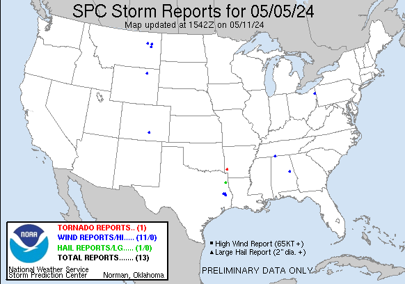
| Tornado Reports (CSV) (Raw Tornado CSV)(?) |
|---|
Time | | Location | County | State | Lat | Lon | Comments |
| 2345 | | 4 ESE Lockesburg | Sevier | AR | 3394 | 9411 | Corrects previous tornado report from 4 ESE Lockesburg. An EF0 landspout tornado with estimated maximum winds near 65 mph briefly touched down on Red Colony Road ... whe (SHV) |
| Hail Reports (CSV) (Raw Hail CSV)(?) |
|---|
Time | Size | Location | County | State | Lat | Lon | Comments |
| 0025 | 100 | Marshall | Harrison | TX | 3254 | 9435 | Public reports hail dime to quarter size across portions of the city. (SHV) |
| Wind Reports (CSV) (Raw Wind CSV)(?) |
|---|
Time | Speed | Location | County | State | Lat | Lon | Comments |
| 1215 | UNK | 1 SE Lufkin | Angelina | TX | 3132 | 9472 | Large oak tree split and uprooted ... blocking roadway on Willow Drive. (SHV) |
| 1240 | UNK | 2 ESE Huntington | Angelina | TX | 3126 | 9454 | A few trees reported down this morning near the intersection of Thornton Road and Lowry Sawmill Road. Time estimated by radar. (SHV) |
| 1246 | UNK | 2 SSW Zavalla | Angelina | TX | 3113 | 9444 | A few trees reported down this morning on FM 1270 near Highway 69 S. Time estimated by radar. (SHV) |
| 1851 | 74 | 1 ESE Vienna | Trumbull | OH | 4125 | 8067 | ASOS station KYNG Youngstown. (CLE) |
| 2356 | UNK | 3 NW Goldville | Clay | AL | 3311 | 8581 | Trees down in the Bluff Springs area. (BMX) |
| 0020 | 65 | 1 NE Echeta | Campbell | WY | 4447 | 10584 | Time estimated from radar. (UNR) |
| 0130 | 79 | 1 WNW Sanders | Treasure | MT | 4629 | 10712 | Delayed report. Tree uprooted. (BYZ) |
| 0225 | 58 | 1 E Circle | McCone | MT | 4742 | 10557 | AWOS station K4U6 1 E Circle. (GGW) |
| 0300 | 59 | 10 S Vida | McCone | MT | 4769 | 10549 | Corrects previous non-tstm wnd gst report from 10 S Vida to reflect that it is indeed a Tstorm Gust. Mesonet station MTCOW 9.9 S Vida (MT DOT). (GGW) |
| 0345 | 61 | 13 NNE Nelson Creek Rec | McCone | MT | 4774 | 10615 | Mesonet station MTM87 Fort Peck S. (GGW) |
| 0911 | UNK | Saint Joseph | Lawrence | TN | 3502 | 8751 | 6 large oak trees up to 5 feet in diameter uprooted and snapped plus power lines blown down along Hwy 43 around 1 mile north of AL border. (OHX) |
| 0957 | 61 | 1 WNW Colorado City | Pueblo | CO | 3795 | 10487 | Mesonet station CCYC2 Colorado City. (PUB) |
|

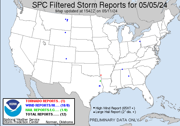
| Filtered Tornado Reports (CSV) (Raw Tornado CSV)(?) |
|---|
Time | | Location | County | State | Lat | Lon | Comments |
| 2345 | | 4 ESE Lockesburg | Sevier | AR | 3394 | 9411 | Corrects previous tornado report from 4 ESE Lockesburg. An EF0 landspout tornado with estimated maximum winds near 65 mph briefly touched down on Red Colony Road ... whe (SHV) |
| Filtered Hail Reports (CSV) (Raw Hail CSV)(?) |
|---|
Time | Size | Location | County | State | Lat | Lon | Comments |
| 0025 | 100 | Marshall | Harrison | TX | 3254 | 9435 | Public reports hail dime to quarter size across portions of the city. (SHV) |
| Filtered Wind Reports (CSV) (Raw Wind CSV)(?) |
|---|
Time | Speed | Location | County | State | Lat | Lon | Comments |
| 1215 | UNK | 1 SE Lufkin | Angelina | TX | 3132 | 9472 | Large oak tree split and uprooted ... blocking roadway on Willow Drive. (SHV) |
| 1240 | UNK | 2 ESE Huntington | Angelina | TX | 3126 | 9454 | A few trees reported down this morning near the intersection of Thornton Road and Lowry Sawmill Road. Time estimated by radar. (SHV) |
| 1851 | 74 | 1 ESE Vienna | Trumbull | OH | 4125 | 8067 | ASOS station KYNG Youngstown. (CLE) |
| 2356 | UNK | 3 NW Goldville | Clay | AL | 3311 | 8581 | Trees down in the Bluff Springs area. (BMX) |
| 0020 | 65 | 1 NE Echeta | Campbell | WY | 4447 | 10584 | Time estimated from radar. (UNR) |
| 0130 | 79 | 1 WNW Sanders | Treasure | MT | 4629 | 10712 | Delayed report. Tree uprooted. (BYZ) |
| 0225 | 58 | 1 E Circle | McCone | MT | 4742 | 10557 | AWOS station K4U6 1 E Circle. (GGW) |
| 0300 | 59 | 10 S Vida | McCone | MT | 4769 | 10549 | Corrects previous non-tstm wnd gst report from 10 S Vida to reflect that it is indeed a Tstorm Gust. Mesonet station MTCOW 9.9 S Vida (MT DOT). (GGW) |
| 0345 | 61 | 13 NNE Nelson Creek Rec | McCone | MT | 4774 | 10615 | Mesonet station MTM87 Fort Peck S. (GGW) |
| 0911 | UNK | Saint Joseph | Lawrence | TN | 3502 | 8751 | 6 large oak trees up to 5 feet in diameter uprooted and snapped plus power lines blown down along Hwy 43 around 1 mile north of AL border. (OHX) |
| 0957 | 61 | 1 WNW Colorado City | Pueblo | CO | 3795 | 10487 | Mesonet station CCYC2 Colorado City. (PUB) |
| The Storm Reports page is organized based on reports received from 1200 UTC to 1159 UTC the next day. For example, storm report page for 20150430 covers reports from 20150430 at 1200 UTC to 20150501 at 1159 UTC. |
| Full report in comma-separated values (CSV) format and in KML format. |
| Full filtered report in comma-separated values (CSV) format and in KML format. |
| KML files are created with time-enabled placemarks compatible with Google Earth Time Slider. |
| Raw full report in comma-separated values (CSV) format. |
| Fields marked UNK are unknown. |
| All Times UTC. |
| Wind Gusts in MPH. |
| Hail Sizes in 1/100 of an Inch (175 = 1.75") |
| LAT/LON in decimal degrees to two decimals, see SPC FAQ for more info. |
| List of Weather Forecast Office 3-letter IDs appear in the report comments section. |
|
|
|
Top/Storm Reports/Home
|
|
|


