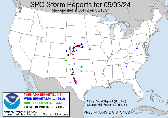
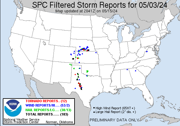
| Tornado Reports (CSV) (Raw Tornado CSV)(?) |
|---|
Time | | Location | County | State | Lat | Lon | Comments |
| 2045 | | 6 SSW Silver | Coke | TX | 3200 | 10073 | (SJT) |
| 2048 | | 4 S Silver | Coke | TX | 3201 | 10067 | (SJT) |
| 2133 | | 3 NNE Hale Center | Hale | TX | 3411 | 10183 | Brief tornado touchdown north-northeast of Hale Center. (LUB) |
| 2153 | | 4 S Robert Lee | Coke | TX | 3184 | 10049 | Very large tornado. (SJT) |
| 2304 | | 4 NE Eden | Concho | TX | 3134 | 9993 | Brief Tornado. (SJT) |
| 2318 | | 4 W Wall | Tom Green | TX | 3137 | 10038 | Trees and fences damaged. Minor cosmetic damage reported to houses in the area. (SJT) |
| 2348 | | 15 S Vancourt | Tom Green | TX | 3113 | 10021 | Remote area southwest of Eden. (SJT) |
| 0110 | | 19 NNW Lakin | Kearny | KS | 3820 | 10135 | [Landspout] Video/photos of possible landspout/gustnado/tornado. (DDC) |
| 0110 | | 19 SW Modoc | Kearny | KS | 3826 | 10128 | Spotter video of a brief mesocyclone tornado in an open field for around 1 minute. Location estimated from spotter and radar. (DDC) |
| 0153 | | 2 W Atlanta | Phelps | NE | 4037 | 9951 | Tornado damage confirmed 2W of Atlanta. Time estimated from radar. Damage survey is still ongoing. (GID) |
| 0208 | | 1 SE Holdrege | Phelps | NE | 4043 | 9936 | This is an update to the initial Holdrege Tornado survey and results in the original track being split into two separate and distinct damage paths ... which are now refe (GID) |
| 0211 | | 1 NNW Holdrege | Phelps | NE | 4046 | 9938 | This is an update to the initial Holdrege Tornado survey and results in the original track being split into two separate and distinct damage paths ... which are now refe (GID) |
| 0213 | | 2 WNW Ragan | Harlan | NE | 4032 | 9933 | Tornado damage confirmed north of Ragan. Time estimated from radar. Survey still ongoing. (GID) |
| 0351 | | 6 N Guide Rock | Webster | NE | 4016 | 9833 | Deputy reported damage from a possible tornado north and northeast of Guide Rock. Tree damage was reported along with a barn shifted off its foundation. Time estimated (GID) |
| 0351 | | 6 N Guide Rock | Webster | NE | 4016 | 9834 | This tornado touched down at 1051 PM CDT 5 to 6 miles north of Guide Rock ... and lifted at 1058 PM CDT 5 miles south of Lawrence. The rating was EF0 ... with an estimate (GID) |
| Hail Reports (CSV) (Raw Hail CSV)(?) |
|---|
Time | Size | Location | County | State | Lat | Lon | Comments |
| 1410 | 200 | Holdrege | Phelps | NE | 4044 | 9938 | (GID) |
| 2045 | 275 | Fluvanna | Scurry | TX | 3289 | 10115 | (MAF) |
| 2045 | 200 | 3 W Fluvanna | Borden | TX | 3289 | 10120 | (MAF) |
| 2057 | 200 | Silver | Coke | TX | 3207 | 10068 | (SJT) |
| 2112 | 175 | 3 WSW Lake Alan Henry | Garza | TX | 3305 | 10110 | Several golf ball sized hailstones observed falling on live webcam. (LUB) |
| 2140 | 175 | 10 S Silver | Coke | TX | 3192 | 10070 | (SJT) |
| 2202 | 275 | 7 SSW Bronte | Coke | TX | 3183 | 10029 | (SJT) |
| 2222 | 100 | 1 NW Grenville | Union | NM | 3660 | 10362 | (ABQ) |
| 2224 | 175 | 4 NNW Orient | Coke | TX | 3171 | 10035 | (SJT) |
| 2225 | 100 | Grenville | Union | NM | 3659 | 10361 | (ABQ) |
| 2229 | 200 | Dickens | Dickens | TX | 3362 | 10084 | (LUB) |
| 2250 | 100 | 2 NW Clayton | Union | NM | 3647 | 10320 | (ABQ) |
| 2257 | 175 | 6 W Harriet | Tom Green | TX | 3153 | 10041 | (SJT) |
| 2307 | 275 | 4 E San Angelo | Tom Green | TX | 3145 | 10038 | Baseball size hail and hail damage reported near FM 308 near the Concho River. (SJT) |
| 2310 | 175 | 4 ENE San Angelo | Tom Green | TX | 3146 | 10039 | (SJT) |
| 2317 | 250 | 2 WNW Wall | Tom Green | TX | 3139 | 10033 | (SJT) |
| 2318 | 275 | Wall | Tom Green | TX | 3138 | 10031 | (SJT) |
| 2319 | 125 | 2.5 E San Angelo | Tom Green | TX | 3145 | 10041 | Hail report from 7849 Ripple Rd off of HWY 87. (SJT) |
| 2327 | 100 | 2 ENE Wall | Tom Green | TX | 3138 | 10027 | (SJT) |
| 2335 | 100 | 4 SSE Channing | Oldham | TX | 3563 | 10231 | Called in quarter sized hail. (AMA) |
| 2337 | 325 | 4 W Vancourt | Tom Green | TX | 3132 | 10025 | Report from mPING: Baseball+ (3.25 in.). (SJT) |
| 2339 | 400 | 4 W Vancourt | Tom Green | TX | 3132 | 10025 | Report from mPING: Grapefruit (4.00 in.). (SJT) |
| 2343 | 175 | 4 NE San Angelo | Tom Green | TX | 3147 | 10039 | Report from mPING: Golf Ball (1.75 in.). (SJT) |
| 2348 | 150 | 5 NW Matador | Motley | TX | 3407 | 10088 | Ping pong ball size hail found on the side of the road between Matador and Whiteflat. Time estimated from radar. (LUB) |
| 2352 | 100 | Tribune | Greeley | KS | 3847 | 10175 | Public report of around 1 inch diameter hail in Tribune. (GLD) |
| 2355 | 125 | 4 W Horace | Greeley | KS | 3847 | 10186 | Report from mPING: Half Dollar (1.25 in.). (GLD) |
| 0012 | 100 | 1 NE Henrietta | Clay | TX | 3382 | 9819 | Report from mPING: Quarter (1.00 in.). (OUN) |
| 0026 | 350 | Quitaque | Briscoe | TX | 3437 | 10106 | Quitaque VFD reports hailstones ranging from 2.25 to 3.5 inches in diameter. (LUB) |
| 0044 | 175 | 6 NNW Boys Ranch | Oldham | TX | 3559 | 10229 | (AMA) |
| 0045 | 100 | 8 NE Fort Mckavett | Menard | TX | 3091 | 10001 | Quarter size hail occasionally from 715 PM until almost 830 PM. (SJT) |
| 0050 | 250 | 10 ENE Fort Mckavett | Menard | TX | 3087 | 9995 | Delayed report: There were many windows broken from the large hail at a house and a few outbuildings. Also ... lots of golf ball size hail and the hail lasted 20 to 30 m (SJT) |
| 0102 | 175 | Lydia | Wichita | KS | 3828 | 10129 | Trained spotter reports golf ball sized hail with heavy rain and about 25 MPH wind gusts. (GLD) |
| 0105 | 150 | 4 S Eustis | Frontier | NE | 4061 | 10003 | (LBF) |
| 0113 | 175 | 7 S Eustis | Frontier | NE | 4056 | 10003 | (LBF) |
| 0119 | 100 | Lydia | Wichita | KS | 3828 | 10129 | Additional 1 inch hail reported with the funnel cloud report. (GLD) |
| 0128 | 100 | Elwood | Gosper | NE | 4059 | 9987 | (GID) |
| 0134 | 200 | 1 NE Smithfield | Gosper | NE | 4058 | 9973 | Report on social media of 2 inch hail near Smithfield. Time estimated from radar. (GID) |
| 0138 | 175 | Herndon | Rawlins | KS | 3991 | 10079 | West side of Herndon reports up to hail golf ball sized hail. (GLD) |
| 0139 | 175 | 1 NW Bertrand | Phelps | NE | 4053 | 9964 | (GID) |
| 0142 | 100 | 1 NW Friend | Scott | KS | 3827 | 10093 | (DDC) |
| 0156 | 100 | Loomis | Phelps | NE | 4048 | 9951 | (GID) |
| 0157 | 125 | Elgin | Comanche | OK | 3478 | 9829 | (OUN) |
| 0157 | 100 | 2 NE Elgin | Comanche | OK | 3480 | 9827 | Report from mPING: Quarter (1.00 in.). (OUN) |
| 0203 | 250 | 1 SSE Cleo | Kimble | TX | 3060 | 9987 | Social media report of golf ball to tennis ball sized hail just south of Cleo. (SJT) |
| 0208 | 100 | Holdrege | Phelps | NE | 4044 | 9938 | Pea to quarter sized hail. (GID) |
| 0210 | 125 | Holdrege | Phelps | NE | 4044 | 9937 | Report on social media of half dollar sized hail in Holdrege. (GID) |
| 0210 | 200 | Holdrege | Phelps | NE | 4044 | 9938 | Corrects previous hail report from Holdrege. (GID) |
| 0210 | 175 | 1 NNE Holdrege | Phelps | NE | 4045 | 9937 | Report on social media of golf ball size hail in Holdrege. (GID) |
| 0213 | 100 | Holdrege | Phelps | NE | 4044 | 9937 | Report from mPING: Quarter (1.00 in.). (GID) |
| 0215 | 100 | 1 S Cement | Caddo | OK | 3492 | 9814 | Report from mPING: Quarter (1.00 in.). (OUN) |
| 0221 | 175 | 4 S Gracemont | Caddo | OK | 3513 | 9825 | via Spotter Network. (OUN) |
| 0223 | 150 | Miami | Roberts | TX | 3569 | 10064 | (AMA) |
| 0235 | 100 | 2 S Axtell | Kearney | NE | 4045 | 9913 | Moved through between 935 through 940. (GID) |
| 0240 | 100 | 6 W Junction | Kimble | TX | 3049 | 9987 | Social media report. (SJT) |
| 0243 | 125 | 4 WNW Chickasha | Grady | OK | 3508 | 9801 | Phone call report. (OUN) |
| 0308 | 100 | 4 SW Upland | Franklin | NE | 4028 | 9896 | Report on social media of quarter sized hail near the Hwy 10 and 4 Junction. Time estimated from radar. (GID) |
| Wind Reports (CSV) (Raw Wind CSV)(?) |
|---|
Time | Speed | Location | County | State | Lat | Lon | Comments |
| 2045 | 59 | 3 WNW Fluvanna | Borden | TX | 3290 | 10120 | (MAF) |
| 2200 | 82 | 4 WSW Lamar | Prowers | CO | 3807 | 10268 | ASOS station KLAA Lamar Airport. (PUB) |
| 2208 | 63 | 5 W Rotan | Fisher | TX | 3285 | 10054 | West Texas Mesonet site. (SJT) |
| 2218 | UNK | 5 NW Hollywood | Jackson | AL | 3476 | 8602 | Tree down in Hollywood ... AL at the intersection of county road 33 and county road 470; time estimated based on radar. Radar evidence does not support a severe storm at (HUN) |
| 2250 | UNK | 2 WSW Peach State Speed | Jackson | GA | 3415 | 8358 | Corrects previous tstm wnd dmg report from 2 WSW Peach State Speedway. Tree on Powerlines near Jett Roberts RD and Village Dr. (FFC) |
| 2250 | UNK | 3 W Peach State Speedwa | Jackson | GA | 3416 | 8360 | Corrects previous tstm wnd dmg report from 3 W Peach State Speedway. Chicken Coup Lifted off ground and several trees down. (FFC) |
| 2307 | 60 | 6 E Heartstrong | Yuma | CO | 3993 | 10247 | Trained spotter estimated winds gusting 50 to 60 MPH. Time estimated based on radar. (GLD) |
| 2317 | 60 | 2 E Wall | Tom Green | TX | 3138 | 10027 | West Texas Mesonet site. (SJT) |
| 2326 | 59 | 2 SSE San Angelo | Tom Green | TX | 3142 | 10044 | (SJT) |
| 2331 | 69 | 29 W Ozona | Crockett | TX | 3067 | 10169 | West Texas Mesonet site at Fort Lancaster. (SJT) |
| 2343 | 61 | 5 E North Platte | Lincoln | NE | 4112 | 10067 | ASOS station KLBF North Platte Airport. (LBF) |
| 2345 | UNK | 2 NNE Moscow | Augusta | VA | 3834 | 7908 | Report of a tree and power line down in the Mt. Solon area. Time estimated. (LWX) |
| 2350 | 63 | 4 E North Platte | Lincoln | NE | 4113 | 10069 | RSOIS measurement. (LBF) |
| 0000 | 62 | Hugo | Lincoln | CO | 3914 | 10347 | Corrects previous non-tstm wnd gst report from Hugo. Mesonet station EW0539 Hugo. (BOU) |
| 0018 | UNK | 1 N Jolly | Clay | TX | 3388 | 9835 | Snapped power poles along FM2393. Radar estimated time. (OUN) |
| 0019 | 61 | 8 NW Bethune | Kit Carson | CO | 3940 | 10251 | KCOSTRAT21 reported a gust of 61 MPH. (GLD) |
| 0024 | UNK | 2 N Bridgewater | Rockingham | VA | 3841 | 7896 | Delayed report. Empty detached semi trailer overturned ... roof removed/tossed from an outbuilding leading to partial collapse ... and multiple trees downed in the vicini (LWX) |
| 0025 | 61 | 8 NNW Boyero | Lincoln | CO | 3902 | 10335 | Mesonet station UP711 7.7 NW Boyero (UPR). (BOU) |
| 0033 | 60 | 2 WNW Menard | Menard | TX | 3093 | 9981 | West Texas Mesonet site. (SJT) |
| 0035 | 58 | 3 SE Oakley | Logan | KS | 3910 | 10082 | AWOS station KOEL 2 ESE Oakley. (GLD) |
| 0042 | 60 | 3 NNW Trenton | Hitchcock | NE | 4021 | 10103 | Trained spotter 1 north of Trenton dam reported estimated 60 MPH wing gust. No hail. (GLD) |
| 0045 | UNK | 7 ENE Fort Mckavett | Menard | TX | 3088 | 10000 | Delayed Report: There was damage to 8 power poles along US 190. The wooden crossarms were snapped off. Also ... power lines were blown down. The estimated wind speed was (SJT) |
| 0049 | 71 | 1 E Mccook | Red Willow | NE | 4021 | 10059 | (GLD) |
| 0055 | UNK | 4 W Menard | Menard | TX | 3092 | 9986 | Delayed Report: There was major damage to an outbuilding. the roof was blown off an thrown about 100 feet. Also ... many tree branches were broken. The time is based on (SJT) |
| 0057 | 59 | 4 E Grinnell | Gove | KS | 3912 | 10056 | UP830 reported a 59 MPH gust. (GLD) |
| 0058 | 62 | 5 N Cambridge | Furnas | NE | 4035 | 10016 | (GID) |
| 0059 | 67 | 9 SSE Stockville | Frontier | NE | 4041 | 10034 | personal weather station. (LBF) |
| 0101 | UNK | 4 N Blakeman | Rawlins | KS | 3988 | 10113 | Numerous 0.75 to 1.5 inch live tree limbs blown down. Large 5.5 inch diameter dead tree limb also down. Reported 0.67 hundredths of rain. Time estimated via radar. (GLD) |
| 0106 | UNK | 10 NNW Cleo | Menard | TX | 3074 | 9995 | Delayed Report: There was major damage to a mobile home and a an outbuilding was swept off its foundation. There were two carports that had mainly roof damage. A 4 whee (SJT) |
| 0129 | 59 | 4 NE Hayne | Seward | KS | 3715 | 10075 | Mesonet station UR350 Kismws. (DDC) |
| 0135 | 60 | 3 N Colby | Thomas | KS | 3943 | 10105 | AWOS station KCBK 2 N Colby. (GLD) |
| 0145 | UNK | 3 W Peach State Speedwa | Jackson | GA | 3416 | 8360 | Chicken Coup Lifted off ground and several trees down. (FFC) |
| 0156 | UNK | Atlanta | Phelps | NE | 4037 | 9948 | House damaged from possible Tornado 1 west of Atlanta on Facebook. Time estimated from radar. (GID) |
| 0215 | 67 | 5 NNW Holdrege | Phelps | NE | 4050 | 9942 | (GID) |
| 0221 | 58 | 9 WSW Winona | Logan | KS | 3900 | 10139 | Mesonet station UP840 9.0 W Winona (UPR). (GLD) |
| 0229 | 59 | 2 ESE Overton | Dawson | NE | 4073 | 9949 | (GID) |
| 0231 | 60 | 1 E Hill City | Graham | KS | 3937 | 9983 | ASOS station KHLC Hill City. (GLD) |
| 0236 | 58 | 7 N Loomis | Phelps | NE | 4058 | 9949 | Corrects previous flood report from 7 N Loomis. (GID) |
| 0245 | 60 | 8 S Elm Creek | Phelps | NE | 4060 | 9939 | (GID) |
| 0247 | UNK | 1 SSE Grainfield | Gove | KS | 3911 | 10046 | Delayed report of a truck flipped ... likely due to strong winds. (GLD) |
| 0250 | 59 | 1 E Hill City | Graham | KS | 3937 | 9983 | ASOS station KHLC Hill City. (GLD) |
| 0255 | 60 | 1 E Odessa | Buffalo | NE | 4070 | 9924 | (GID) |
| 0259 | 58 | 3 E Riverdale | Buffalo | NE | 4078 | 9910 | (GID) |
| 0300 | 62 | 5 SSE Odessa | Phelps | NE | 4063 | 9923 | (GID) |
| 0314 | 60 | 3 NNE Kearney | Buffalo | NE | 4074 | 9906 | (GID) |
| 0319 | 68 | 4 N Kearney | Buffalo | NE | 4076 | 9910 | (GID) |
| 0324 | 72 | 6 ESE Lora | Hemphill | TX | 3571 | 10046 | This wind gust occurred under a thunderstorm anvil ... and was not caused by a notable thunderstorm on radar. (AMA) |
| 0358 | 63 | 2 NNE Norman | Kearney | NE | 4050 | 9878 | (GID) |
| 0400 | 65 | Grand Island Airport | Hall | NE | 4097 | 9831 | Corrects previous tstm wnd gst report of 64 MPH from Grand Island Airport. (GID) |
| 0401 | UNK | 4 S Lawrence | Nuckolls | NE | 4022 | 9826 | Viewer reported damage 4S of Lawrence. Some sheds were damaged along with some tree tops. (GID) |
| 0407 | 64 | 2 N Hastings | Adams | NE | 4061 | 9839 | (GID) |
| 0410 | UNK | 4 S Nelson | Nuckolls | NE | 4015 | 9807 | Livestock Trailer Truck flipped over at junction of Hwy 136E and Hwy14. (GID) |
| 0415 | 60 | 1 ESE Doniphan | Hall | NE | 4077 | 9836 | NWS Employee estimates 60 to 65 mph winds in Doniphan. (GID) |
| 0416 | 60 | Deweese | Clay | NE | 4035 | 9814 | Est 50-60mph with heavy rain and near zero visibility. (GID) |
| 0418 | 58 | Grand Island Airport | Hall | NE | 4097 | 9831 | ASOS Records 58 mph wind gust at 11:18pm. (GID) |
| 0430 | 79 | 4 WNW Davenport | Nuckolls | NE | 4033 | 9788 | Mesonet recorded a 79 mph wind gust at 11:30pm. (GID) |
| 0435 | UNK | 4 SW Archer | Merrick | NE | 4112 | 9818 | Facebook photo of power pole damage. Power outages were reported in the Central City and Palmer areas. Time estimated from radar. (GID) |
| 0453 | 60 | Marquette | Hamilton | NE | 4096 | 9803 | Heavy rain with wind gusts of 50-60mph. (GID) |
| 0515 | 67 | 2 SE Carleton | Thayer | NE | 4028 | 9764 | Mesonet recorded 67mph at 12:07am. (GID) |
| 0919 | UNK | 1 W Huron | Atchison | KS | 3964 | 9536 | EM reports damage to outbuildings at two locations within a mile of each other west of Huron. Based on images and radar data ... it appears to be straight line winds bet (EAX) |


 @NWSSPC