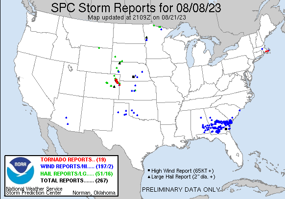
| Tornado Reports (CSV) (Raw Tornado CSV)(?) |
|---|
Time | | Location | County | State | Lat | Lon | Comments |
| 1520 | | 2 WNW Mattapoisett | Plymouth | MA | 4168 | 7085 | Corrects previous tornado report from 2 WNW Mattapoisett. A small EF-1 tornado touched down in the town of Mattapoisett Massachusetts at 11:20 AM EDT. The storm was on (BOX) |
| 1552 | | 2 NE Marstons Mills | Barnstable | MA | 4168 | 7039 | A small EF-0 tornado touched down in the town of Barnstable ... near the village of Marstons Mills ... at 11:52 AM. The storm tracked ENE from Evergreen Drive for approxi (BOX) |
| 2250 | | 2 NW Hyde | Washington | CO | 4015 | 10285 | Corrects time based on radar. Report from 2 NW Hyde. WA298 ... seen from Yuma. (BOU) |
| 2257 | | 1 ESE Hyde | Washington | CO | 4013 | 10281 | Garage was lifted off foundation anchoring and shifted. Garage doors imploded ... and about 100f roof structure was lost. Other tree damage on farm suggested EF1 damag (BOU) |
| 2257 | | 2 NW Hyde | Washington | CO | 4015 | 10285 | WA298 ... seen from Yuma. (BOU) |
| 2302 | | 2 SW Yuma | Yuma | CO | 4010 | 10276 | Tornado on the ground estimated 3 miles west of the airport. Location estimated. (GLD) |
| 2313 | | 5 S Yuma | Yuma | CO | 4005 | 10272 | 5 power poles snapped along Hwy 59. Time estimated. (GLD) |
| 2330 | | 7 NNW Heartstrong | Yuma | CO | 4005 | 10262 | Delayed report via social media. Multi-vortex tornado reported roughly 7-8 miles southeast of Yuma. Location approximate based on radar. Tornado has lifted prior to 5:5 (GLD) |
| 2340 | | 6 NW Heartstrong | Yuma | CO | 4000 | 10266 | Corrects previous DELAYED REPORT tornado report from 6 NW Heartstrong. DELAYED REPORT of a tornado 1.5-2 Miles west of CR 30 and K. Videos and photos sent in via social (GLD) |
| 0006 | | 2 NNE Abarr | Yuma | CO | 3987 | 10271 | Brief tornado lasted about 2 minutes (6:08PM) roughly 2-3 miles NW of County Rds L and and 18 intersection. (GLD) |
| 0019 | | 5 SW Heartstrong | Yuma | CO | 3989 | 10263 | Tornado just touched down via Chaser live feed. Location estimated via radar. (GLD) |
| 0025 | | 3 E Abarr | Yuma | CO | 3985 | 10266 | Storm chasers were 7 miles north of Joes looking to the northwest. They commented they saw rope tornado for about a minute and a half ... emerging out of rain shaft. Pos (GLD) |
| 0030 | | 5 SE Abarr | Yuma | CO | 3980 | 10265 | Ongoing tornado reported. Location roughly 10 miles NW of Kirk. Location estimated via radar and report. (GLD) |
| 0110 | | 8 W Idalia | Yuma | CO | 3968 | 10245 | Chaser sent video of ongoing tornado that was dissipated as of 7:13 PM. Video observed from Roads T and 8. Time and location estimated via radar. (GLD) |
| 0111 | | 7 NE Kirk | Yuma | CO | 3969 | 10251 | Delayed report via social media. Brief condensed and uncondensed circulations roughly 7 miles NE of Kirk from 7 to 7:15 PM MDT. Image taken at County Rd 3 and R. Locati (GLD) |
| 0125 | | 8 SW Idalia | Yuma | CO | 3961 | 10240 | Partially condensed cone tornado now rain wrapped. Location estimated via radar. Chaser was 11 miles SW of Idalia. (GLD) |
| 0127 | | 8 SSW Idalia | Yuma | CO | 3960 | 10237 | Chaser reported ongoing stovepipe tornado. Chaser was located 21 miles NW of Burlington. Location of report based on radar. (GLD) |
| 0321 | | 3 SSE Kanorado | Sherman | KS | 3929 | 10201 | Possible tornado damage to an abandoned structure along with downed powerlines east of County Rd 3 on County Rd 61. Timing estimated via radar. (GLD) |
| 0321 | | 3 SSE Kanorado | Sherman | KS | 3930 | 10202 | Tornado debris signature (TDS) observed via KGLD 0.5 and 0.9 degree tilts at 0321 UTC. Correlation Coefficient dropout to 0.60-0.75 coincident with velocity couplet and (GLD) |
| Hail Reports (CSV) (Raw Hail CSV)(?) |
|---|
Time | Size | Location | County | State | Lat | Lon | Comments |
| 1955 | 100 | 3 NW Ray | Koochiching | MN | 4844 | 9324 | Mostly dime size hail with a few hailstones around quarter size. Time approximate. Storm started around two thirty PM and was ending around time of phone call around th (DLH) |
| 2010 | 100 | 1 SSW Kabetogama | St. Louis | MN | 4843 | 9303 | Pea to quarter size hail. Time estimated from radar. (DLH) |
| 2040 | 100 | Baudette | Lake of the Woods | MN | 4871 | 9459 | DELAYED REPORT. Workers at Baudette Airport report quarter sized hail. Time estimated. (FGF) |
| 2055 | 100 | 6 N Sheridan | Sheridan | WY | 4489 | 10697 | (BYZ) |
| 2127 | 100 | Byron | Peach | GA | 3265 | 8376 | (FFC) |
| 2130 | 100 | 1 E Centerville | Houston | GA | 3263 | 8367 | 1.00 hail reported near the intersection of Gunn Rd and US HWY 41. (FFC) |
| 2159 | 100 | 10 SE Alliance | Morrill | NE | 4200 | 10274 | (CYS) |
| 2208 | 175 | 6 S Burdett | Washington | CO | 4028 | 10297 | (BOU) |
| 2208 | 200 | Hawley | Clay | MN | 4688 | 9632 | Picture relayed by broadcast media. Time estimated from radar. (FGF) |
| 2215 | 200 | Hawley | Clay | MN | 4688 | 9632 | Corrects previous hail report from Hawley. Picture relayed by broadcast media. Time estimated from radar. (FGF) |
| 2236 | 100 | 5 NNW Fairburn | Custer | SD | 4375 | 10324 | Mostly smaller. Time is when the largest hail was falling. (UNR) |
| 2300 | 275 | 7 N Abarr | Yuma | CO | 3995 | 10272 | Delayed report via social media with picture. Time estimated. (GLD) |
| 2300 | 175 | 4 NE Yuma | Yuma | CO | 4016 | 10267 | Delayed report via social media. (GLD) |
| 2302 | 300 | Hyde | Washington | CO | 4013 | 10283 | DE175. (BOU) |
| 2305 | 225 | 1 WNW Hyde | Washington | CO | 4013 | 10284 | Report from mPING: Hen Egg+ (2.25 in.). (BOU) |
| 2307 | 150 | 11 NNE Kutch | Elbert | CO | 3905 | 10380 | (BOU) |
| 2307 | 300 | Hyde | Washington | CO | 4013 | 10283 | Report from mPING: Tea Cup (3.00 in.). (BOU) |
| 2308 | 400 | 3 W Yuma | Yuma | CO | 4012 | 10278 | (GLD) |
| 2315 | 275 | 7 N Abarr | Yuma | CO | 3995 | 10272 | Corrects previous hail report from 7 N Abarr. Delayed report via social media with picture. Time estimated. (GLD) |
| 2316 | 100 | 4 SE Yuma | Yuma | CO | 4008 | 10266 | Report from mPING: Quarter (1.00 in.). (GLD) |
| 2317 | 175 | 4 N Sterling | Logan | CO | 4069 | 10321 | Corrects previous hail report from 4 N Sterling. L06. (BOU) |
| 2318 | 175 | 4 ESE Yuma | Yuma | CO | 4010 | 10266 | Hail was ongoing at the location. (GLD) |
| 2334 | 300 | 6 NNW Heartstrong | Yuma | CO | 4004 | 10261 | Delayed report via social media with photo of hailstones. Time estimated. (GLD) |
| 2345 | 175 | 7 SSE Hyde | Washington | CO | 4003 | 10280 | Lost power as well. (BOU) |
| 2345 | 175 | 6 SSW Yuma | Yuma | CO | 4005 | 10277 | Up to golf ball hail observed. Power was out at the residence. (GLD) |
| 2348 | 175 | 10 WSW Hugo | Lincoln | CO | 3907 | 10364 | (BOU) |
| 2359 | 125 | 7 S Yuma | Yuma | CO | 4003 | 10272 | Report from mPING: Half Dollar (1.25 in.). (GLD) |
| 0017 | 150 | 7 N Abarr | Yuma | CO | 3995 | 10271 | Report from mPING: Ping Pong Ball (1.50 in.). (GLD) |
| 0020 | 250 | 6 N Abarr | Yuma | CO | 3994 | 10271 | Report from mPING: Tennis Ball (2.50 in.). (GLD) |
| 0026 | 250 | Gordon | Sheridan | NE | 4281 | 10220 | golf ball sized hail to just smaller than baseball sized. (LBF) |
| 0027 | 175 | Gordon | Sheridan | NE | 4281 | 10220 | Golfball sized hail. (LBF) |
| 0028 | 175 | Gordon | Sheridan | NE | 4280 | 10220 | Public reports golf ball sized hail. (LBF) |
| 0030 | 400 | 6 WSW Heartstrong | Yuma | CO | 3993 | 10268 | Storm chaser reported 3.5 inch to 4 inch hail near the intersection of Highway 59 and County Road 25 at approximately 6:30 pm MDT. (GLD) |
| 0038 | 250 | 4 W Idalia | Yuma | CO | 3970 | 10238 | Social media report with pictures of hail ranging from golf ball to tennis ball in size. (GLD) |
| 0045 | 175 | 9 NNE Gordon | Sheridan | NE | 4292 | 10214 | Public reports 15 min period of golf ball sized hail with leaf damage on many trees in area. (LBF) |
| 0109 | 100 | Idalia | Yuma | CO | 3970 | 10229 | Report from mPING: Quarter (1.00 in.). (GLD) |
| 0113 | 125 | Idalia | Yuma | CO | 3970 | 10229 | Report from mPING: Half Dollar (1.25 in.). (GLD) |
| 0116 | 150 | Idalia | Yuma | CO | 3970 | 10229 | Report from mPING: Ping Pong Ball (1.50 in.). (GLD) |
| 0120 | 175 | 7 S Martin | Bennett | SD | 4307 | 10171 | Storm lasted half an hour. Also received 0.70 inches of rain. Delayed report. (UNR) |
| 0122 | 500 | 8 WSW Idalia | Yuma | CO | 3966 | 10244 | Hail measured at 5.25 inches fell on Hwy 36. Time and location estimated. (GLD) |
| 0122 | 500 | 8 ENE Kirk | Yuma | CO | 3966 | 10245 | Corrects previous hail report from 8 WSW Idalia. Hail measured at 5.25 inches fell on Hwy 36. Time estimated. New LSR created with exact location stone was picked up. (GLD) |
| 0148 | 100 | 12 N Kanorado | Sherman | KS | 3951 | 10201 | Social media report of hail between pea to quarter in size from 7:48pm-7:53pm. (GLD) |
| 0313 | 125 | 4 SSE Kanorado | Sherman | KS | 3928 | 10201 | estimated time of report. the size is estimated from divots in the ground. (GLD) |
| 0320 | 100 | 3 E Peconic | Kit Carson | CO | 3933 | 10210 | Hail observed at MM 447 on I-70. (GLD) |
| 0425 | 250 | 12 NNE Aroya | Cheyenne | CO | 3902 | 10308 | Baseball size hail broke numerous double paned windows in a home in extreme northwest Cheyenne County. A few miles away ... quarter to golf ball size hail accumulated to (GLD) |
| 0500 | 150 | 9 NNW Oshkosh | Garden | NE | 4153 | 10241 | Report via social media. (LBF) |
| 0513 | 100 | 2 NNE Parker | Douglas | CO | 3954 | 10476 | (BOU) |
| 0540 | 125 | 5 NNE Ponderosa Park | Elbert | CO | 3946 | 10459 | Report from mPING: Half Dollar (1.25 in.). (BOU) |
| 0551 | 100 | 5 NE Ponderosa Park | Elbert | CO | 3946 | 10459 | Report from mPING: Quarter (1.00 in.). (BOU) |
| 0557 | 175 | 8 NE Ponderosa Park | Elbert | CO | 3947 | 10451 | Report via X. (BOU) |
| 0721 | 100 | Hoisington | Barton | KS | 3852 | 9878 | (ICT) |
| Wind Reports (CSV) (Raw Wind CSV)(?) |
|---|
Time | Speed | Location | County | State | Lat | Lon | Comments |
| 1305 | UNK | 3 SSW Gilbert | Maricopa | AZ | 3331 | 11181 | 2 uprooted trees with trunks of 6 to 8 inch diameter. Winds estimated at 50-60 mph. (PSR) |
| 1310 | UNK | Rothsay | Wilkin | MN | 4648 | 9629 | Delayed report: 10 inch healthy tree blown down ... time estimated from radar. (FGF) |
| 1326 | 63 | 2 WSW MYRTLE BEACH | HORRY | SC | 3368 | 7893 | RECORDED BY KMYR AWOS (ILM) |
| 1407 | UNK | 3 NNW Starrs Mill | Fayette | GA | 3337 | 8454 | Tree Down. (FFC) |
| 1425 | UNK | Holliston | Middlesex | MA | 4220 | 7143 | Large tree and wires down on Ashland Street. (BOX) |
| 1520 | UNK | 2 WNW Mattapoisett | Plymouth | MA | 4168 | 7085 | Trees and wires down on Hereford Hill Rd. Relayed by amateur radio. (BOX) |
| 1520 | UNK | 2 NW Mattapoisett | Plymouth | MA | 4169 | 7083 | trees and wires down on North Street around Eldorado Dr. relayed by amateur radio. (BOX) |
| 1605 | UNK | Barnstable | Barnstable | MA | 4170 | 7030 | Several reports of trees and wires down and trees blocking the road on West Barnstable Road in Osterville and on Commerce Road at Main Street. (BOX) |
| 1615 | UNK | 2 WSW Barnstable | Barnstable | MA | 4169 | 7034 | tree down along Rt 6 near exit 68. relayed by amateur radio. (BOX) |
| 1651 | UNK | Mattapoisett | Plymouth | MA | 4166 | 7081 | Numerous trees down in the Tinkham Lane area as well as on Acushnet Road and Stoney Hill Road. (BOX) |
| 1849 | UNK | Auburn Univ Montgomery | Montgomery | AL | 3237 | 8617 | Large tree limb down near the intersection of Taylor Road and East Drive (near Auburn University at Montgomery). Tree limb measured 8 inches in diameter. (BMX) |
| 1855 | UNK | 3 E Sprague | Montgomery | AL | 3214 | 8622 | Several trees down across southern portions of Montgomery County ... AL. (BMX) |
| 1900 | UNK | 1 SSE Ramer | Montgomery | AL | 3203 | 8621 | Trees and power lines down on Ramer Grady Road. (BMX) |
| 1921 | UNK | 2 N Troy Muni Airport | Pike | AL | 3189 | 8600 | Multiple trees down along County Road 7714 in northern Pike County ... AL. (BMX) |
| 1935 | UNK | 5 WNW Aberfoil | Bullock | AL | 3208 | 8577 | Multiple trees down on Highway 223 and on Highway 29. (BMX) |
| 1955 | UNK | 1 SSW Clayton | Barbour | AL | 3187 | 8546 | Tree down on louisville street. Time estimated by radar. (BMX) |
| 1955 | UNK | 1 ENE Rutherford | Russell | AL | 3219 | 8531 | Reports of multiple trees down between Hurtsboro ... AL and Pittsview ... AL. (BMX) |
| 2014 | UNK | Eufaula | Barbour | AL | 3189 | 8515 | Report of multiple trees and powerlines down in and around Eufaula. (BMX) |
| 2015 | UNK | 2 ENE Eanon | Coffee | AL | 3153 | 8583 | Coffee County dispatch reported downed powerlines on CR-127. (TAE) |
| 2015 | UNK | 2 WNW Dooling | Dooly | GA | 3224 | 8396 | large tree down on a house along hwy 90 near Lester Rd. (FFC) |
| 2019 | UNK | 1 E Barefield Crossroad | Dale | AL | 3155 | 8544 | Tree down on CR 69. Time estimated by radar. (TAE) |
| 2019 | UNK | 2 ENE Atwater | Upson | GA | 3298 | 8434 | A tree was reported down across Thompson Rd. (FFC) |
| 2020 | UNK | 2 ENE Atwater | Upson | GA | 3298 | 8434 | Tree blocking both lanes of Thompson Rd. (FFC) |
| 2021 | UNK | 8 E Pittsview | Russell | AL | 3219 | 8502 | Trees down on Bluff Creek Road and Patterson Road. (BMX) |
| 2022 | UNK | 2 NNW Piney Grove | Coffee | AL | 3120 | 8607 | A tree was blown down onto County Road 492. (TAE) |
| 2025 | UNK | 1 S Georgetown | Quitman | GA | 3186 | 8511 | 2 trees down on Winding Way Road. Time estimated by radar. (TAE) |
| 2025 | UNK | 3 SSW Henderson | Houston | GA | 3231 | 8381 | Tree downed along Whitfield Road. (FFC) |
| 2025 | UNK | 2 W Henderson | Houston | GA | 3234 | 8383 | Tree down at the intersection of Scott Rd and Hwy 26. (FFC) |
| 2029 | UNK | Abbeville | Henry | AL | 3157 | 8525 | Trees and powerlines down on West Washington Street and East Washington Street. (TAE) |
| 2040 | UNK | Unadilla | Dooly | GA | 3226 | 8374 | A tree fell onto power lines on School Ave at 2nd St. (FFC) |
| 2045 | UNK | Cuthbert | Randolph | GA | 3177 | 8479 | Numerous trees down across the county. (TAE) |
| 2045 | UNK | 3 N Preston | Webster | GA | 3211 | 8453 | Multiple trees were reported down across Webster county including a number of roads that were impassable ... all north of HWY 280. (FFC) |
| 2045 | UNK | 2 WNW Buena Vista | Marion | GA | 3233 | 8456 | A tree fell onto a power line on Murray Farm Rd and caused a fire in a wooded area. (FFC) |
| 2100 | UNK | Dawson | Terrell | GA | 3177 | 8445 | Numerous trees down countywide. (TAE) |
| 2100 | UNK | Ellaville | Schley | GA | 3224 | 8431 | Trees and powerlines reported down throughout Ellaville including: 57th Block of N. Stevens St. 465th Block of N Broad St. 39th Block of Bridges St. (FFC) |
| 2120 | UNK | Leesburg | Lee | GA | 3173 | 8417 | A couple trees down around Leesburg. Stop light blown from overhanging wire and impacted car. Other stop light is still hanging from partially-downed wire. (TAE) |
| 2120 | UNK | Powerville | Peach | GA | 3260 | 8380 | Numerous trees uprooted or snapped on both sides of hwy 49. (FFC) |
| 2130 | UNK | 1 S Huber | Twiggs | GA | 3270 | 8354 | Tree and Powerlines down. (FFC) |
| 2135 | UNK | 4 S Armena | Dougherty | GA | 3162 | 8429 | Trees were blown down at Old Dawson Road/Winifred Road. (TAE) |
| 2135 | UNK | 3 SSW Warner Robins | Houston | GA | 3257 | 8365 | Trees knocked down destroying a wooden fence. (FFC) |
| 2135 | UNK | 3 SSE Centerville | Houston | GA | 3258 | 8368 | tree down along Steeplechase Run. (FFC) |
| 2135 | UNK | 1 ESE Fitzpatrick | Twiggs | GA | 3274 | 8343 | Trees Down. (FFC) |
| 2135 | UNK | 3 N Huber | Twiggs | GA | 3275 | 8353 | Trees Down. (FFC) |
| 2139 | UNK | Doles | Worth | GA | 3170 | 8389 | Numerous trees down countywide. (TAE) |
| 2140 | UNK | 2 SSW Palmyra | Dougherty | GA | 3161 | 8420 | Trees were blown down at Nottingham Way/Whispering Pines Road. (TAE) |
| 2140 | UNK | 3 ESE Lakewood | Houston | GA | 3256 | 8370 | Tree down on a house along Welney Circle. (FFC) |
| 2140 | UNK | 2 SW Warner Robins | Houston | GA | 3260 | 8365 | Tree down along Bigham Dr. (FFC) |
| 2140 | UNK | 2 SW Warner Robins | Houston | GA | 3260 | 8366 | Tree down along Rolling Woods Circle. (FFC) |
| 2141 | UNK | 1 SW Warner Robins | Houston | GA | 3261 | 8364 | Tree down on a house along Lakeshore Dr. (FFC) |
| 2142 | UNK | 3 SSE Warner Robins | Houston | GA | 3258 | 8362 | Tree down along Garden Ct. (FFC) |
| 2145 | UNK | 2 NNW Albany | Dougherty | GA | 3160 | 8418 | Trees were blown down at the 1400 block of 11th Avenue. (TAE) |
| 2145 | UNK | 2 N Bonaire | Houston | GA | 3257 | 8359 | Tree and powerline down on a car near the intersection of Sandy Run Rd and S. Hwy 247. (FFC) |
| 2145 | UNK | 2 NNW Marion | Twiggs | GA | 3268 | 8344 | Tree Down. (FFC) |
| 2146 | UNK | 2 NW Bonaire | Houston | GA | 3257 | 8363 | Tree and powerlines downed along Lake Placid Dr. (FFC) |
| 2150 | UNK | Sylvester | Worth | GA | 3153 | 8384 | Numerous trees down countywide. (TAE) |
| 2150 | UNK | 1 ESE East Albany | Dougherty | GA | 3157 | 8411 | Trees were blown down at Oglethorpe Boulevard/Liberty Expressway. (TAE) |
| 2150 | UNK | Albany | Dougherty | GA | 3158 | 8418 | Numerous trees down countywide. (TAE) |
| 2150 | UNK | 2 WSW Houston Lake | Houston | GA | 3249 | 8371 | Tree and powerlines downed along Raven Ave. (FFC) |
| 2150 | UNK | 3 SE Lakewood | Houston | GA | 3254 | 8372 | Tree down along royal crest circle. (FFC) |
| 2150 | UNK | 4 WSW Danville | Twiggs | GA | 3259 | 8330 | Tree Down. (FFC) |
| 2152 | UNK | Colquitt | Miller | GA | 3117 | 8473 | Trees and powerlines down on East Crawford in Colquitt. (TAE) |
| 2152 | UNK | 3 ESE Cooktown | Baker | GA | 3119 | 8452 | Tree down on 91 South in Baker County. Time estimated by radar. (TAE) |
| 2154 | UNK | 3 SSW Tarversville | Twiggs | GA | 3250 | 8345 | 20 plus trees down and powerlines. (FFC) |
| 2159 | 70 | 3 SSE Chula | Tift | GA | 3151 | 8352 | Handheld anemometer measured 70 mph gust. (TAE) |
| 2200 | UNK | Tifton | Tift | GA | 3145 | 8351 | Numerous trees down countywide. (TAE) |
| 2208 | UNK | 3 SSW Harding | Tift | GA | 3149 | 8345 | Trees down on Mount Olive Church Road. One tree fell on a school bus. No injuries. (TAE) |
| 2211 | 60 | 3 NE Moultrie | Colquitt | GA | 3120 | 8375 | Trained spotter measured 60 mph gust on roof top anemometer. (TAE) |
| 2212 | UNK | 2 SSE Westwood | Ben Hill | GA | 3171 | 8328 | Trees were blown down along Walker Ave on the west side of Fitzgerald. (TAE) |
| 2215 | UNK | Fitzgerald | Ben Hill | GA | 3171 | 8326 | A pecan tree and power lines were blown down on West Roanoke Drive. (TAE) |
| 2215 | UNK | 1 NE Montrose | Laurens | GA | 3257 | 8314 | Tree Down. (FFC) |
| 2215 | UNK | 2 NE Montrose | Laurens | GA | 3258 | 8313 | Powerlines Down. (FFC) |
| 2217 | UNK | 2 E Chester | Laurens | GA | 3239 | 8312 | Tree Down. (FFC) |
| 2220 | UNK | Fitzgerald | Ben Hill | GA | 3172 | 8325 | Numerous trees down countywide. (TAE) |
| 2220 | UNK | 3 ENE Dexter | Laurens | GA | 3244 | 8301 | Tree Down. (FFC) |
| 2220 | UNK | 5 SW Chappells Mill | Laurens | GA | 3262 | 8311 | Tree Down. (FFC) |
| 2222 | UNK | 2 SE Pineboro | Colquitt | GA | 3115 | 8365 | Large tree branches around 5 inches in diameter and one small tree were blown down. (TAE) |
| 2222 | UNK | 1 WNW Orianna | Laurens | GA | 3248 | 8267 | Tree Down. (FFC) |
| 2224 | UNK | 3 NNE Minter | Laurens | GA | 3253 | 8275 | Tree Down. (FFC) |
| 2224 | UNK | 1 SW Dublin | Laurens | GA | 3253 | 8292 | Tree Down. (FFC) |
| 2224 | UNK | 1 W Dublin | Laurens | GA | 3254 | 8292 | Tree Down. (FFC) |
| 2224 | UNK | 1 NW Dublin | Laurens | GA | 3255 | 8292 | Tree Down. (FFC) |
| 2225 | UNK | Ocilla | Irwin | GA | 3160 | 8325 | Several trees down across the county. (TAE) |
| 2225 | UNK | 2 WSW Dublin | Laurens | GA | 3253 | 8293 | Powerlines Down. (FFC) |
| 2225 | UNK | 1 NNW Dublin | Laurens | GA | 3255 | 8291 | Powerline Down. (FFC) |
| 2226 | UNK | 1 E Jacksonville | Telfair | GA | 3181 | 8296 | A tree was reported down on a powerline along HWY 117. (FFC) |
| 2229 | UNK | 2 WNW Collins | Tattnall | GA | 3219 | 8214 | One tree down reported on HWY 292 and Jack Anderson Rd. (CHS) |
| 2230 | UNK | 3 SE Rentz | Laurens | GA | 3236 | 8296 | Tree Down. (FFC) |
| 2230 | UNK | 2 NW Lowery | Laurens | GA | 3238 | 8282 | Tree Down. (FFC) |
| 2230 | UNK | 2 NNW Orianna | Laurens | GA | 3249 | 8266 | Tree Down. (FFC) |
| 2232 | UNK | Collins | Tattnall | GA | 3218 | 8211 | One tree reported down on Oak Road and Church Road. Time estimated from radar. (CHS) |
| 2233 | UNK | Coolidge | Thomas | GA | 3101 | 8387 | Tree down in Coolidge. Time estimated by radar. (TAE) |
| 2235 | UNK | Ambrose | Coffee | GA | 3159 | 8301 | Trees were reported down all across Coffee county. Time was estimated by radar. More specific locations will be provided later. (JAX) |
| 2235 | UNK | 2 E East Dublin | Laurens | GA | 3255 | 8284 | Tree Down. (FFC) |
| 2240 | UNK | Pavo | Thomas | GA | 3096 | 8374 | Power pole down in Pavo. (TAE) |
| 2240 | UNK | 2 ENE Minter | Laurens | GA | 3250 | 8273 | Powerlines Down. (FFC) |
| 2242 | UNK | 1 NE Sparks | Cook | GA | 3118 | 8343 | Tree down on McCranie Road in Sparks. (TAE) |
| 2244 | UNK | 7 WSW Glennville | Tattnall | GA | 3191 | 8204 | One tree reported down on Hwy 144 and 178. Time estimated from radar. (CHS) |
| 2245 | UNK | 5 E Hahira | Lowndes | GA | 3099 | 8329 | A tree was blown down onto a power line near Coppage Road and Skipper Bridge Road. (TAE) |
| 2245 | UNK | Nashville | Berrien | GA | 3121 | 8325 | Numerous trees down on the west side of Berrien County. Storms still moving across eastern half of the county. (TAE) |
| 2250 | UNK | 3 SE Hahira | Lowndes | GA | 3096 | 8334 | A tree was blown down onto a power line at 5100 Fiveash Road. (TAE) |
| 2250 | UNK | 1 NW Mount Vernon | Montgomery | GA | 3219 | 8260 | Multiple reports of structural damage on the NW side of Mt. Vernon along McKinnon Street. (FFC) |
| 2255 | UNK | 1 W Hyde | Washington | CO | 4013 | 10285 | Small barn flipped on its side. Estimated wind gust to 90 mph per damage indicator. Also minor shingle damage to manufactured home at this location. Time estimated by o (BOU) |
| 2258 | UNK | 1 SW Orr | St. Louis | MN | 4805 | 9283 | Spotter reports that a tree 12 to 14 inches in diameter was blown over. This tree then fell on a couple of power poles and broke them. Time of wind damage estimated fro (DLH) |
| 2300 | UNK | 4 W Picture Rocks | Pima | AZ | 3236 | 11132 | Power poles knocked down at N Anway Rd and N Tucker Rd. (TWC) |
| 2300 | UNK | 1 WNW Hyde | Washington | CO | 4013 | 10285 | Pub State patrol. (BOU) |
| 2302 | UNK | 5 N Pearson | Atkinson | GA | 3138 | 8284 | Tree limbs and trees down near Pearson. Radar estimated time. (JAX) |
| 2305 | UNK | Quitman | Brooks | GA | 3079 | 8356 | Numerous trees and power lines were blown down across the county. (TAE) |
| 2305 | UNK | 2 W Oak Park | Emanuel | GA | 3235 | 8236 | Trees Down. (FFC) |
| 2310 | UNK | 4 ESE Oak Park | Emanuel | GA | 3233 | 8226 | Trees Down. (FFC) |
| 2310 | UNK | 4 NW Oak Park | Emanuel | GA | 3239 | 8236 | Trees Down. (FFC) |
| 2313 | UNK | Reidsville | Tattnall | GA | 3209 | 8212 | Multiple trees reported down in Reidsville ... GA. Time estimated from radar. (CHS) |
| 2313 | UNK | 2 E Groveland | Bryan | GA | 3214 | 8171 | A 911 call center reported a tree down across the roadway near the 4900 block of Hwy 280 W. Time was estimated via radar data. (CHS) |
| 2313 | UNK | Groveland | Bryan | GA | 3214 | 8175 | A 911 call center reported two trees and a power line down along Hwy 280 ... located near the cross streets of Harvey Rd as well as Groveland Nevils Rd. Time was estimed (CHS) |
| 2313 | UNK | Collins | Tattnall | GA | 3218 | 8211 | Multiple trees reported down in Collins ... GA. Time estimated from radar. (CHS) |
| 2313 | UNK | Cobbtown | Tattnall | GA | 3228 | 8214 | Multiple trees down in Cobbtown ... GA. (CHS) |
| 2314 | UNK | 4 WNW Aline | Candler | GA | 3238 | 8222 | Candler County Sheriff's Office reported a tree down on powerlines near the intersection of Griffin Ferry Road and 46 West. (CHS) |
| 2315 | 59 | 2 WSW Alma | Bacon | GA | 3153 | 8250 | ASOS station KAMG Alma. (JAX) |
| 2315 | UNK | Madray Springs | Wayne | GA | 3173 | 8198 | 3 separate reports of trees down across roads in Madray Springs. Time estimated from radar. (JAX) |
| 2315 | UNK | 4 NE Oak Park | Emanuel | GA | 3241 | 8227 | Tree on house. (FFC) |
| 2316 | UNK | 2 E Groveland | Bryan | GA | 3214 | 8171 | A 911 call center reported a power line down across the railroad track near the 3300 block of Hwy 280 W. Time was estimated via radar data. (CHS) |
| 2320 | UNK | 3 NW Bristol | Pierce | GA | 3148 | 8225 | Tree down on Mershon Rd. Time estimated from radar. (JAX) |
| 2320 | UNK | 3 S Yuma | Yuma | CO | 4008 | 10272 | Corrects previous tornado report from 5 S Yuma from a NWS Storm Survey. 5 power poles snapped along Hwy 59. Time estimated. (GLD) |
| 2322 | UNK | Bellville | Evans | GA | 3215 | 8197 | Multiple trees reported down in Bellville ... GA. Time estimated from radar. (CHS) |
| 2322 | UNK | 2 ESE Aline | Candler | GA | 3235 | 8213 | Candler County Sheriff's Office reported trees and powerlines down in several locations including on Macwac Lake Road ... Holland Road ... and Freedom Lane. (CHS) |
| 2325 | 64 | Metter Airport | Candler | GA | 3237 | 8208 | Metter Airport gusted to 56 kts (64 mph). Time updated from radar. (CHS) |
| 2328 | UNK | 1 S Ellabell | Bryan | GA | 3211 | 8148 | 911 call center reported power line down at the intersection of Porterfield and Indian Trail Rd. Time was estimated via radar data. (CHS) |
| 2329 | UNK | Metter | Candler | GA | 3240 | 8206 | Metter fire department chief reported multiple trees down across the town of Metter. (CHS) |
| 2330 | UNK | 4 S Patterson | Pierce | GA | 3133 | 8214 | Tree down on Billy Rd. Time estimated from radar. (JAX) |
| 2330 | UNK | 5 S Pulaski | Candler | GA | 3231 | 8197 | Candler County Sheriff's Office reported trees and powerlines down near Excelsior including on Excelsior Road and Dutch Fork Road. (CHS) |
| 2332 | UNK | Register | Bulloch | GA | 3237 | 8188 | Multiple trees down reported in Register ... GA. Time estimated from radar. (CHS) |
| 2333 | UNK | Douglas | Coffee | GA | 3151 | 8285 | A metal street sign was blown over at the intersection of Peterson Ave and Ward street. Time was estimated by radar. (JAX) |
| 2335 | UNK | Claxton | Evans | GA | 3216 | 8190 | Multiple trees reported down across Claxton ... GA. Time estimated from radar. (CHS) |
| 2338 | UNK | 2 SW Hinesville | Liberty | GA | 3183 | 8161 | One tree reported down in Hinesville ... GA. Time estimated from radar. (CHS) |
| 2340 | UNK | 1 NNW Burroughs | Chatham | GA | 3199 | 8126 | One tree uprooted on Chevis Road. Time estimated from radar. (CHS) |
| 2341 | UNK | 3 NW Burroughs | Chatham | GA | 3200 | 8128 | Tree reported down on Abercorn Street at Gateway Blvd. Time estimated from radar. (CHS) |
| 2341 | UNK | Daisy | Evans | GA | 3215 | 8184 | Multiple trees down reported in Daisy ... GA. (CHS) |
| 2342 | UNK | Daisy | Evans | GA | 3215 | 8183 | Tree reported down on 600 block of Railroad Avenue in Daisy ... GA. Time estimated from radar. (CHS) |
| 2344 | UNK | 4 SSW Garden City | Chatham | GA | 3204 | 8120 | Tree reported down on Salt Creek Road. Time estimated from radar. (CHS) |
| 2345 | UNK | 4 WSW Hoboken | Brantley | GA | 3117 | 8219 | Trees and powerlines down along High Bluff Road. Report received via social media. Time was estimated by radar. (JAX) |
| 2346 | UNK | 2 W Garden City | Chatham | GA | 3210 | 8120 | Tree down on Old Louisville Road. Time estimated from radar. (CHS) |
| 2346 | UNK | Port Wentworth | Chatham | GA | 3215 | 8118 | Tree reported down on Augusta Road at Crossgate Road. Time estimated from radar. (CHS) |
| 2346 | UNK | Stilson | Bulloch | GA | 3233 | 8156 | Multiple trees reported down in Stilson ... GA. Time estimated from radar. (CHS) |
| 2346 | UNK | 3 WNW Stilson | Bulloch | GA | 3234 | 8160 | Multiple trees reported down in Arcola ... GA. Time estimated from radar. (CHS) |
| 2346 | UNK | Brooklet | Bulloch | GA | 3238 | 8166 | Multiple trees down reported in Brooklet ... GA. Time estimated from radar. (CHS) |
| 2349 | 79 | 3 SW Nahunta | Brantley | GA | 3119 | 8202 | The University of Georgia mesonet site at the ZBLU Berry Farm south of US Highway 82 and west of US Highway 301 reported this gust. (JAX) |
| 2350 | UNK | 6 NNW Pearson | Atkinson | GA | 3138 | 8290 | A total of 7 different reports of trees down in Atkinson County. Most notable areas were near Sunnyside Church Rd and TR Hattaway Rd areas. Time estimated from radar. (JAX) |
| 2350 | UNK | 1 WNW White Bluff | Chatham | GA | 3199 | 8114 | Tree reported down on Grove Point Road. Time estimated from radar. (CHS) |
| 2350 | 60 | Oshkosh | Garden | NE | 4141 | 10234 | 50 to 60 mph wind gusts ... blew several potted plants off of porch. (LBF) |
| 2355 | UNK | 2 SSW Savannah | Chatham | GA | 3202 | 8109 | Tree reported down on Harlan Dr. Time estimated from radar. (CHS) |
| 2357 | UNK | 1 SSE Savannah | Chatham | GA | 3204 | 8107 | Tree reported down on Northgate Rd. Time estimated from radar. (CHS) |
| 2358 | UNK | Midway | Liberty | GA | 3181 | 8143 | One tree reported down in Midway ... GA. Time estimated from radar. (CHS) |
| 2358 | UNK | Sandfly | Chatham | GA | 3198 | 8108 | Tree reported down on Ferguson Avenue at Marvalingrove Dr. Time estimated from radar. (CHS) |
| 0003 | UNK | 7 SSW Pritchardville | Jasper | SC | 3215 | 8102 | Tree reported down on Bellinger Hill and Zig Zag road. Time estimated from radar. (CHS) |
| 0003 | UNK | 5 SW Pritchardville | Jasper | SC | 3220 | 8103 | Tree reported down on Cooks Landing road. Time estimated from radar. (CHS) |
| 0005 | UNK | 2 NNE Sandfly | Chatham | GA | 3201 | 8107 | *** 1 FATAL *** Chatham County Police Department and Chatham County Emergency Management Agency reported one fatality due to a tree falling on a vehicle in the 5600 blo (CHS) |
| 0009 | UNK | 1 NE Pine Harbor | McIntosh | GA | 3156 | 8136 | One tree reported down on Belle Bluff Road. Time estimated from radar. (CHS) |
| 0014 | 62 | 1 SSW Tybee Island | Chatham | GA | 3199 | 8085 | Tybee South weather flow (XTYE) gusted to 62 mph. (CHS) |
| 0015 | 65 | 2 ENE Tybee Island | AMZ352 | GA | 3201 | 8081 | Savannah Entrance Light weather flow (XSEL) gusted to 65 mph. (CHS) |
| 0019 | UNK | Ebenezer | Effingham | GA | 3238 | 8118 | One tree reported down on Ebenezer Road. Time estimated from radar. (CHS) |
| 0019 | 60 | 1 ESE Abarr | Yuma | CO | 3985 | 10270 | (GLD) |
| 0024 | UNK | 1 SSE Hardeeville | Jasper | SC | 3227 | 8108 | Jasper County dispatch reported a tree down near the intersection of Moorer Avenue and Burke Street. (CHS) |
| 0026 | UNK | 3 NNE Purysburgh | Jasper | SC | 3234 | 8109 | Jasper County dispatch reported a tree down near the intersection of Deerfield Road and Old Charleston Highway. (CHS) |
| 0028 | UNK | 2 NNW Hardeeville | Jasper | SC | 3232 | 8109 | Jasper County dispatch reported a tree down near the intersection of Deerfield Road and Deer Lane. (CHS) |
| 0030 | UNK | 2 SE Pritchardville | Beaufort | SC | 3222 | 8094 | A 911 call center reported a tree down along New Riverside Rd. Time was estimated via radar data. (CHS) |
| 0031 | UNK | Hardeeville | Jasper | SC | 3228 | 8108 | Tree down on Paynesville and Deerfield Road. Time estimated from radar. (CHS) |
| 0034 | UNK | Brunswick | Glynn | GA | 3115 | 8148 | Delayed report and time estimated by radar. A tree down on Magnolia Avenue in Brunswick GA. (JAX) |
| 0034 | UNK | 1 N Brunswick | Glynn | GA | 3117 | 8149 | Delayed report and time estimated by radar. Tree reported down on Bartow St in Brunswick GA. (JAX) |
| 0035 | UNK | 3 NE Pritchardville | Beaufort | SC | 3226 | 8092 | A 911 call center reported a tree down along Innovation Dr. Time was estimated via radar data. (CHS) |
| 0039 | UNK | 2 WNW Ridgeland | Jasper | SC | 3249 | 8101 | Tree down reported on Great Swamp road. Time estimated from radar. (CHS) |
| 0041 | UNK | 2 NNE Bluffton | Beaufort | SC | 3227 | 8085 | A 911 call center reported a tree down along Waterford Dr. Time was estimated via radar data. (CHS) |
| 0041 | UNK | 1 NNW Ridgeland | Jasper | SC | 3250 | 8099 | Jasper County dispatch reported a tree down in the 1500 block of Grays Highway near the Ridgeland Airport due to thunderstorm outflow. (CHS) |
| 0042 | UNK | St Simons Island GA | Glynn | GA | 3118 | 8137 | Delayed report and time estimated by radar. A tree was reported down at Sasser Point on St Simons Island. (JAX) |
| 0103 | UNK | 2 SE Pritchardville | Beaufort | SC | 3222 | 8094 | A 911 call center reported a tree down along New Riverside Rd. Time was estimated via radar data. (CHS) |
| 0110 | UNK | Rothsay | Wilkin | MN | 4648 | 9629 | Corrects previous tstm wnd dmg report from Rothsay. Delayed report: 10 inch healthy tree blown down ... time estimated from radar. (FGF) |
| 0110 | UNK | 3 SE Lawndale | Wilkin | MN | 4653 | 9633 | Delayed report: Tree damage to grove ... time estimated from radar. (FGF) |
| 0120 | 68 | 3 NNE Umbarger | Randall | TX | 3499 | 10208 | Peak wind gust of 68 mph measured by mesonet at 8:20 PM ... followed by a 58 mph gust at 8:21 PM ... then dropped below severe levels. (AMA) |
| 0203 | UNK | 2 NNW Ashepoo | Colleton | SC | 3277 | 8056 | Emergency manager reported a tree down along 3500 Bonnie Doon Rd. Time was estimated via radar data. (CHS) |
| 0300 | UNK | 1 SSE Peconic | Kit Carson | CO | 3931 | 10214 | Social media report with picture of a few healthy 2 inch tree limbs down. Estimated to have occurred around 9pm to 9:15pm. (GLD) |
| 0320 | 61 | 2 S Lesley | Hall | TX | 3465 | 10081 | Measured by the West Texas Mesonet (LUB) |
| 0321 | 66 | 2 S Lesley | Hall | TX | 3465 | 10081 | Peak gust measured by the West Texas Mesonet. The site measured several gusts in excess of 58 mph between 1019 PM and 1034 PM. (LUB) |
| 0334 | 58 | 1 ENE Mclean | Gray | TX | 3524 | 10057 | (AMA) |
| 0340 | 61 | 1 NE Memphis | Hall | TX | 3473 | 10053 | Measured by the West Texas Mesonet. (LUB) |
| 0349 | 68 | 1 NE Memphis | Hall | TX | 3473 | 10053 | Peak wind gust measured by the West Texas Mesonet. A few additonal severe wind gusts occurred between 1040 pm and 1051 pm. (LUB) |
| 0406 | 72 | 1 E Odessa | Buffalo | NE | 4070 | 9924 | (GID) |
| 0410 | 77 | 1 E Odessa | Buffalo | NE | 4070 | 9924 | (GID) |
| 0415 | UNK | Kearney | Buffalo | NE | 4070 | 9908 | An around three inch in diameter healthy tree branch snapped. (GID) |
| 0422 | 61 | 4 N Gibbon | Buffalo | NE | 4081 | 9884 | Delayed report via NeRAIN comment. Time estimated from radar. (GID) |
| 0508 | 60 | 2 NNE Hastings | Adams | NE | 4062 | 9838 | Personal Weather Station. (GID) |
| 0525 | 62 | 6 SSE Elk City | Beckham | OK | 3533 | 9939 | Elk City (ELKC) Mesonet. (OUN) |
| 0540 | 68 | 4 SE Hobart | Kiowa | OK | 3499 | 9905 | Hobart (HOBA) Mesonet. (OUN) |
| 0544 | UNK | Columbus | Platte | NE | 4143 | 9736 | Delayed report. Photo on social media showing part of a tree blown down in Frankfort Square. Time estimated from radar. (OAX) |
| 0545 | 60 | 4 SE Hobart | Kiowa | OK | 3499 | 9905 | Hobart (HOBA) Mesonet. (OUN) |
| 0645 | UNK | Lawton | Comanche | OK | 3461 | 9839 | Power poles down. Pictures on Slack. Time estimated from radar. (OUN) |
| 0715 | UNK | 9 SSW Osborne | Osborne | KS | 3932 | 9879 | Delayed report of isolated damage on a farmstead including part of an outbuilding roof blown off and a bulk bin blown over. Time estimated from radar data. (GID) |
| 0729 | 60 | 3 W Nekoma | Rush | KS | 3847 | 9949 | Personal weather station ... via Wunderground ... station KKSALEXA8. (DDC) |
| 0810 | 66 | Albert | Barton | KS | 3846 | 9901 | Personal weather station. (ICT) |
| 1130 | UNK | 1 NW Pell City | St. Clair | AL | 3359 | 8629 | Trees were blown down in the Harrisburg area of Pell City. (BMX) |


 @NWSSPC