|
20220416's Storm Reports (20220416 1200 UTC - 20220417 1159 UTC) (Print Version)
|
< 220415 Reports
220417 Reports >
|
| Note: All Reports Are Considered Preliminary |
|
|
|
|

| Tornado Reports (CSV) (Raw Tornado CSV)(?) |
|---|
| No reports received |
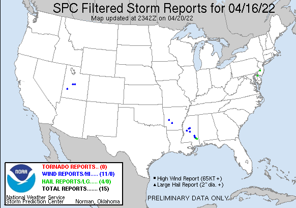
| Hail Reports (CSV) (Raw Hail CSV)(?) |
|---|
Time | Size | Location | County | State | Lat | Lon | Comments |
| 2040 | 150 | 1 NNE MULBERRY | WAYNE | MS | 3149 | 8885 | PING PONG SIZED HAIL REPORTED BY PUBLIC. VIA SOCIAL MEDIA. TIME ESTIMATED BY RADAR. (MOB) |
| 2044 | 175 | 18 SW WAYNESBORO | WAYNE | MS | 3149 | 8886 | (MOB) |
| 2045 | 175 | PIAVE | GREENE | MS | 3139 | 8875 | PHOTO OF LARGE HAIL RECEIVED ON OFFICE SOCIAL MEDIA ACCOUNTS. (MOB) |
| 2055 | 175 | PIAVE | GREENE | MS | 3139 | 8875 | PHOTO OF LARGE HAIL RECEIVED ON OFFICE SOCIAL MEDIA ACCOUNTS. (MOB) |
| 0028 | 100 | 1 W SOUTH JERSEY REGION | BURLINGTON | NJ | 3994 | 7486 | REPORT FROM MPING: QUARTER (1.00 IN.). (PHI) |
| 0034 | 100 | 1 NNW CHESWOLD | KENT | DE | 3923 | 7559 | (PHI) |
| Wind Reports (CSV) (Raw Wind CSV)(?) |
|---|
Time | Speed | Location | County | State | Lat | Lon | Comments |
| 1212 | UNK | 2 NE GRAVEL JUNCTION | CLARK | AR | 3407 | 9293 | TREES WERE DOWN ALONG MANCHESTER ROAD ... SHANDY ROAD ... AND HIGHWAY 128. (LZK) |
| 1352 | UNK | 1 NE SILVER | MONTGOMERY | AR | 3455 | 9349 | TREES WERE BLOWN DOWN AT DENBY POINT CAMPGROUND. (LZK) |
| 1718 | UNK | 2 NW FRANKLIN | HOLMES | MS | 3307 | 9003 | A COUPLE OF TREES WERE BLOWN DOWN ON HIGHWAY 17 NEAR LEXINGTON. (JAN) |
| 1730 | UNK | 5 N LITTLE YAZOO | YAZOO | MS | 3278 | 9037 | TREES DOWN ACROSS THE COUNTY. (JAN) |
| 1735 | UNK | DURANT | HOLMES | MS | 3308 | 8985 | TREES DOWN AROUND DURANT. (JAN) |
| 1830 | UNK | 1 WNW RATLIFF FERRY | MADISON | MS | 3260 | 8985 | CORRECTS PREVIOUS TSTM WND DMG REPORT FROM 1 WNW RATLIFF FERRY. A TREE WAS BLOWN DOWN ALONG THE NATCHEZ TRACE AND RATLIFF FERRY ROAD. ANOTHER TREE WAS BLOWN DOWN ALONG (JAN) |
| 2004 | UNK | OAK BOWERY | JASPER | MS | 3193 | 8908 | TREES DOWNED IN THE OAK BOWERY COMMUNITY. REPORT VIA SOCIAL MEDIA. (JAN) |
| 2041 | UNK | 4 NE GLADE | JONES | MS | 3170 | 8906 | TREES AND POWER LINES DOWNED ON MS HWY 184. (JAN) |
| 2142 | 61 | MILFORD | BEAVER | UT | 3840 | 11302 | MILFORD ASOS (SLC) |
| 2150 | 58 | 5 SW SCIPIO | MILLARD | UT | 3920 | 11217 | UTSCI SENSOR (SLC) |
| 2210 | 62 | 5 WSW MANTI | SANPETE | UT | 3924 | 11171 | PC098 SENSOR AT GUNNISON RESERVOIR (SLC) |
|
| Filtered Tornado Reports (CSV) (Raw Tornado CSV)(?) |
|---|
| No reports received |
| Filtered Hail Reports (CSV) (Raw Hail CSV)(?) |
|---|
Time | Size | Location | County | State | Lat | Lon | Comments |
| 2044 | 175 | 18 SW WAYNESBORO | WAYNE | MS | 3149 | 8886 | (MOB) |
| 2045 | 175 | PIAVE | GREENE | MS | 3139 | 8875 | PHOTO OF LARGE HAIL RECEIVED ON OFFICE SOCIAL MEDIA ACCOUNTS. (MOB) |
| 0028 | 100 | 1 W SOUTH JERSEY REGION | BURLINGTON | NJ | 3994 | 7486 | REPORT FROM MPING: QUARTER (1.00 IN.). (PHI) |
| 0034 | 100 | 1 NNW CHESWOLD | KENT | DE | 3923 | 7559 | (PHI) |
| Filtered Wind Reports (CSV) (Raw Wind CSV)(?) |
|---|
Time | Speed | Location | County | State | Lat | Lon | Comments |
| 1212 | UNK | 2 NE GRAVEL JUNCTION | CLARK | AR | 3407 | 9293 | TREES WERE DOWN ALONG MANCHESTER ROAD ... SHANDY ROAD ... AND HIGHWAY 128. (LZK) |
| 1352 | UNK | 1 NE SILVER | MONTGOMERY | AR | 3455 | 9349 | TREES WERE BLOWN DOWN AT DENBY POINT CAMPGROUND. (LZK) |
| 1718 | UNK | 2 NW FRANKLIN | HOLMES | MS | 3307 | 9003 | A COUPLE OF TREES WERE BLOWN DOWN ON HIGHWAY 17 NEAR LEXINGTON. (JAN) |
| 1730 | UNK | 5 N LITTLE YAZOO | YAZOO | MS | 3278 | 9037 | TREES DOWN ACROSS THE COUNTY. (JAN) |
| 1735 | UNK | DURANT | HOLMES | MS | 3308 | 8985 | TREES DOWN AROUND DURANT. (JAN) |
| 1830 | UNK | 1 WNW RATLIFF FERRY | MADISON | MS | 3260 | 8985 | CORRECTS PREVIOUS TSTM WND DMG REPORT FROM 1 WNW RATLIFF FERRY. A TREE WAS BLOWN DOWN ALONG THE NATCHEZ TRACE AND RATLIFF FERRY ROAD. ANOTHER TREE WAS BLOWN DOWN ALONG (JAN) |
| 2004 | UNK | OAK BOWERY | JASPER | MS | 3193 | 8908 | TREES DOWNED IN THE OAK BOWERY COMMUNITY. REPORT VIA SOCIAL MEDIA. (JAN) |
| 2041 | UNK | 4 NE GLADE | JONES | MS | 3170 | 8906 | TREES AND POWER LINES DOWNED ON MS HWY 184. (JAN) |
| 2142 | 61 | MILFORD | BEAVER | UT | 3840 | 11302 | MILFORD ASOS (SLC) |
| 2150 | 58 | 5 SW SCIPIO | MILLARD | UT | 3920 | 11217 | UTSCI SENSOR (SLC) |
| 2210 | 62 | 5 WSW MANTI | SANPETE | UT | 3924 | 11171 | PC098 SENSOR AT GUNNISON RESERVOIR (SLC) |
| The Storm Reports page is organized based on reports received from 1200 UTC to 1159 UTC the next day. For example, storm report page for 20150430 covers reports from 20150430 at 1200 UTC to 20150501 at 1159 UTC. |
| Full report in comma-separated values (CSV) format and in KML format. |
| Full filtered report in comma-separated values (CSV) format and in KML format. |
| KML files are created with time-enabled placemarks compatible with Google Earth Time Slider. |
| Raw full report in comma-separated values (CSV) format. |
| Fields marked UNK are unknown. |
| All Times UTC. |
| Wind Gusts in MPH. |
| Hail Sizes in 1/100 of an Inch (175 = 1.75") |
| LAT/LON in decimal degrees to two decimals, see SPC FAQ for more info. |
| List of Weather Forecast Office 3-letter IDs appear in the report comments section. |
|
|
|
Top/Storm Reports/Home
|
|
|


 @NWSSPC