|
20210314's Storm Reports (20210314 1200 UTC - 20210315 1159 UTC) (Print Version)
|
< 210313 Reports
210315 Reports >
|
| Note: All Reports Are Considered Preliminary |
|
|
|
|
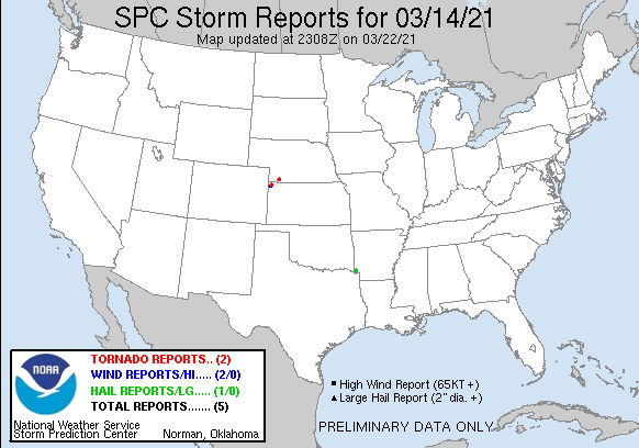
| Tornado Reports (CSV) (Raw Tornado CSV)(?) |
|---|
Time | | Location | County | State | Lat | Lon | Comments |
| 1750 | | WHEELER | CHEYENNE | KS | 3976 | 10171 | LANDSPOUT REPORTED NEAR THE LANDFILL. (GLD) |
| 1933 | | 2 W TRENTON | HITCHCOCK | NE | 4017 | 10105 | SOCIAL MEDIA REPORT AND PHOTO OF A LANDSPOUT. LANDSPOUT WAS SPOTTED ON THE EAST SIDE OF TRENTON DAM AND DISSIPATED NEAR THE SOUTHWEST EDGE OF TRENTON. ON THE GROUND FOR (GLD) |
| Hail Reports (CSV) (Raw Hail CSV)(?) |
|---|
Time | Size | Location | County | State | Lat | Lon | Comments |
| 2215 | 150 | 7 SE WINTHROP | LITTLE RIVER | AR | 3377 | 9426 | LARGE HAIL REPORTED IN THE ALLEENE COMMUNITY. (SHV) |
| Wind Reports (CSV) (Raw Wind CSV)(?) |
|---|
Time | Speed | Location | County | State | Lat | Lon | Comments |
| 1745 | UNK | 3 SE SAINT FRANCIS | CHEYENNE | KS | 3974 | 10177 | CORRECTS PREVIOUS TSTM WND DMG REPORT FROM 3 SE SAINT FRANCIS. CORRECTS PREVIOUS TSTM WND DMG REPORT FROM 3 SE SAINT FRANCIS. CORRECTS PREVIOUS TSTM WND DMG REPORT FROM (GLD) |
| 1750 | UNK | 3 SSE SAINT FRANCIS | CHEYENNE | KS | 3973 | 10177 | CHEYENNE CO EM REPORTED A GRAIN BIN IN THE ROAD ALONG COUNTY ROAD 16. TIME ESTIMATED BASED ON REPORT OF LANDSPOUT IN WHEELER. (GLD) |
|
| Filtered Tornado Reports (CSV) (Raw Tornado CSV)(?) |
|---|
Time | | Location | County | State | Lat | Lon | Comments |
| 1750 | | WHEELER | CHEYENNE | KS | 3976 | 10171 | LANDSPOUT REPORTED NEAR THE LANDFILL. (GLD) |
| 1933 | | 2 W TRENTON | HITCHCOCK | NE | 4017 | 10105 | SOCIAL MEDIA REPORT AND PHOTO OF A LANDSPOUT. LANDSPOUT WAS SPOTTED ON THE EAST SIDE OF TRENTON DAM AND DISSIPATED NEAR THE SOUTHWEST EDGE OF TRENTON. ON THE GROUND FOR (GLD) |
| Filtered Hail Reports (CSV) (Raw Hail CSV)(?) |
|---|
Time | Size | Location | County | State | Lat | Lon | Comments |
| 2215 | 150 | 7 SE WINTHROP | LITTLE RIVER | AR | 3377 | 9426 | LARGE HAIL REPORTED IN THE ALLEENE COMMUNITY. (SHV) |
| Filtered Wind Reports (CSV) (Raw Wind CSV)(?) |
|---|
Time | Speed | Location | County | State | Lat | Lon | Comments |
| 1745 | UNK | 3 SE SAINT FRANCIS | CHEYENNE | KS | 3974 | 10177 | CORRECTS PREVIOUS TSTM WND DMG REPORT FROM 3 SE SAINT FRANCIS. CORRECTS PREVIOUS TSTM WND DMG REPORT FROM 3 SE SAINT FRANCIS. CORRECTS PREVIOUS TSTM WND DMG REPORT FROM (GLD) |
| The Storm Reports page is organized based on reports received from 1200 UTC to 1159 UTC the next day. For example, storm report page for 20150430 covers reports from 20150430 at 1200 UTC to 20150501 at 1159 UTC. |
| Full report in comma-separated values (CSV) format and in KML format. |
| Full filtered report in comma-separated values (CSV) format and in KML format. |
| KML files are created with time-enabled placemarks compatible with Google Earth Time Slider. |
| Raw full report in comma-separated values (CSV) format. |
| Fields marked UNK are unknown. |
| All Times UTC. |
| Wind Gusts in MPH. |
| Hail Sizes in 1/100 of an Inch (175 = 1.75") |
| LAT/LON in decimal degrees to two decimals, see SPC FAQ for more info. |
| List of Weather Forecast Office 3-letter IDs appear in the report comments section. |
|
|
|
Top/Storm Reports/Home
|
|
|


 @NWSSPC