|
20210312's Storm Reports (20210312 1200 UTC - 20210313 1159 UTC) (Print Version)
|
< 210311 Reports
210313 Reports >
|
| Note: All Reports Are Considered Preliminary |
|
|
|
|

| Tornado Reports (CSV) (Raw Tornado CSV)(?) |
|---|
Time | | Location | County | State | Lat | Lon | Comments |
| 2305 | | 3 NNW SHALLOWATER | LUBBOCK | TX | 3373 | 10201 | (LUB) |
| 0016 | | 4 N RALLS | CROSBY | TX | 3374 | 10138 | (LUB) |
| 0218 | | 15 SW PADUCAH | COTTLE | TX | 3386 | 10049 | (LUB) |
| Hail Reports (CSV) (Raw Hail CSV)(?) |
|---|
Time | Size | Location | County | State | Lat | Lon | Comments |
| 1639 | 100 | 1 S HAYSVILLE | SEDGWICK | KS | 3755 | 9735 | KSN METEOROLOGIST REPORTED THAT HER PARENTS RECEIVED LOTS OF PEA SIZED AND A FEW PIECES QUARTER SIZED HAIL. (ICT) |
| 2304 | 100 | 8 ENE ANTON | HALE | TX | 3386 | 10203 | (LUB) |
| 2340 | 100 | 3 S SAYRE | BECKHAM | OK | 3534 | 9964 | CORRECTS PREVIOUS HAIL REPORT FROM 3 N SAYRE. TWITTER POST WITH VIDEO. (OUN) |
| 0013 | 250 | 1 NE PETERSBURG | HALE | TX | 3388 | 10158 | RELAYED BY WFO OUN (LUB) |
| 0202 | 125 | 1 SSW FRITCH | HUTCHINSON | TX | 3563 | 10160 | CORRECTS PREVIOUS HAIL REPORT FROM 1 SSW FRITCH. REPORT FROM MPING: HALF DOLLAR (1.25 IN.). (AMA) |
| 0203 | 100 | 2 W FRITCH | MOORE | TX | 3564 | 10162 | (AMA) |
| 0212 | 125 | SANFORD | HUTCHINSON | TX | 3570 | 10154 | TWITTER REPORT OF DOLLAR SIZE HAIL WITH PHOTO. (AMA) |
| 0225 | 125 | 3 N BORGER | HUTCHINSON | TX | 3571 | 10141 | SOME HAIL WAS ACCUMULATING ON THE GROUND. (AMA) |
| 0247 | 175 | 4 E DELWIN | COTTLE | TX | 3388 | 10033 | (LUB) |
| 0411 | 100 | PAMPA | GRAY | TX | 3555 | 10096 | (AMA) |
| 0823 | 125 | 7 SSE TECOLOTE | SAN MIGUEL | NM | 3537 | 10523 | (ABQ) |
| Wind Reports (CSV) (Raw Wind CSV)(?) |
|---|
Time | Speed | Location | County | State | Lat | Lon | Comments |
| 1212 | 63 | 1 N GODDARD | SEDGWICK | KS | 3767 | 9758 | (ICT) |
| 1225 | 60 | 2 SE DOWNTOWN WICHITA | SEDGWICK | KS | 3766 | 9731 | PENNY SIZED HAIL WAS REPORTED AS WELL. (ICT) |
| 0057 | 64 | 3 NNW MCADOO | DICKENS | TX | 3377 | 10103 | (LUB) |
| 0119 | UNK | 2 W AFTON | DICKENS | TX | 3376 | 10085 | POWER LINES DOWN AND POWER POLES SNAPPED (LUB) |
|
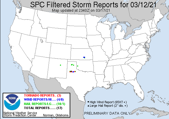
| Filtered Tornado Reports (CSV) (Raw Tornado CSV)(?) |
|---|
Time | | Location | County | State | Lat | Lon | Comments |
| 2305 | | 3 NNW SHALLOWATER | LUBBOCK | TX | 3373 | 10201 | (LUB) |
| 0016 | | 4 N RALLS | CROSBY | TX | 3374 | 10138 | (LUB) |
| 0218 | | 15 SW PADUCAH | COTTLE | TX | 3386 | 10049 | (LUB) |
| Filtered Hail Reports (CSV) (Raw Hail CSV)(?) |
|---|
Time | Size | Location | County | State | Lat | Lon | Comments |
| 1639 | 100 | 1 S HAYSVILLE | SEDGWICK | KS | 3755 | 9735 | KSN METEOROLOGIST REPORTED THAT HER PARENTS RECEIVED LOTS OF PEA SIZED AND A FEW PIECES QUARTER SIZED HAIL. (ICT) |
| 2304 | 100 | 8 ENE ANTON | HALE | TX | 3386 | 10203 | (LUB) |
| 2340 | 100 | 3 S SAYRE | BECKHAM | OK | 3534 | 9964 | CORRECTS PREVIOUS HAIL REPORT FROM 3 N SAYRE. TWITTER POST WITH VIDEO. (OUN) |
| 0013 | 250 | 1 NE PETERSBURG | HALE | TX | 3388 | 10158 | RELAYED BY WFO OUN (LUB) |
| 0202 | 125 | 1 SSW FRITCH | HUTCHINSON | TX | 3563 | 10160 | CORRECTS PREVIOUS HAIL REPORT FROM 1 SSW FRITCH. REPORT FROM MPING: HALF DOLLAR (1.25 IN.). (AMA) |
| 0203 | 100 | 2 W FRITCH | MOORE | TX | 3564 | 10162 | (AMA) |
| 0225 | 125 | 3 N BORGER | HUTCHINSON | TX | 3571 | 10141 | SOME HAIL WAS ACCUMULATING ON THE GROUND. (AMA) |
| 0247 | 175 | 4 E DELWIN | COTTLE | TX | 3388 | 10033 | (LUB) |
| 0411 | 100 | PAMPA | GRAY | TX | 3555 | 10096 | (AMA) |
| 0823 | 125 | 7 SSE TECOLOTE | SAN MIGUEL | NM | 3537 | 10523 | (ABQ) |
| Filtered Wind Reports (CSV) (Raw Wind CSV)(?) |
|---|
Time | Speed | Location | County | State | Lat | Lon | Comments |
| 1212 | 63 | 1 N GODDARD | SEDGWICK | KS | 3767 | 9758 | (ICT) |
| 1225 | 60 | 2 SE DOWNTOWN WICHITA | SEDGWICK | KS | 3766 | 9731 | PENNY SIZED HAIL WAS REPORTED AS WELL. (ICT) |
| 0057 | 64 | 3 NNW MCADOO | DICKENS | TX | 3377 | 10103 | (LUB) |
| 0119 | UNK | 2 W AFTON | DICKENS | TX | 3376 | 10085 | POWER LINES DOWN AND POWER POLES SNAPPED (LUB) |
| The Storm Reports page is organized based on reports received from 1200 UTC to 1159 UTC the next day. For example, storm report page for 20150430 covers reports from 20150430 at 1200 UTC to 20150501 at 1159 UTC. |
| Full report in comma-separated values (CSV) format and in KML format. |
| Full filtered report in comma-separated values (CSV) format and in KML format. |
| KML files are created with time-enabled placemarks compatible with Google Earth Time Slider. |
| Raw full report in comma-separated values (CSV) format. |
| Fields marked UNK are unknown. |
| All Times UTC. |
| Wind Gusts in MPH. |
| Hail Sizes in 1/100 of an Inch (175 = 1.75") |
| LAT/LON in decimal degrees to two decimals, see SPC FAQ for more info. |
| List of Weather Forecast Office 3-letter IDs appear in the report comments section. |
|
|
|
Top/Storm Reports/Home
|
|
|


 @NWSSPC