|
20200330's Storm Reports (20200330 1200 UTC - 20200331 1159 UTC) (Print Version)
|
< 200329 Reports
200331 Reports >
|
| Note: All Reports Are Considered Preliminary |
|
|
|
|
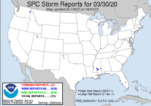
| Tornado Reports (CSV) (Raw Tornado CSV)(?) |
|---|
Time | | Location | County | State | Lat | Lon | Comments |
| 2222 | | 10 N PANTEX | CARSON | TX | 3547 | 10157 | THE TORNADO TOUCHED DOWN AT 0522 PM CDT APPROXIMATELY 10 MILES NORTH OF PANTEX. THE PATH LENGTH WAS 3.55 MILES AND THE PATH WIDTH WAS 50.0 YARDS. THE TORNADO LIFTED AT (AMA) |
| 2250 | | 10 N SUNRAY | SHERMAN | TX | 3616 | 10182 | THE TORNADO TOUCHED DOWN AT 0550 PM CDT APPROXIMATELY 10 MILES NORTH OF SUNRAY. THE PATH LENGTH WAS 0.21 MILE AND THE PATH WIDTH WAS 20.0 YARDS. THE TORNADO MOVED VERY (AMA) |
| Hail Reports (CSV) (Raw Hail CSV)(?) |
|---|
| No reports received |
| Wind Reports (CSV) (Raw Wind CSV)(?) |
|---|
Time | Speed | Location | County | State | Lat | Lon | Comments |
| 1833 | UNK | 1 WSW 5 MILE | SPOKANE | WA | 4773 | 11748 | REPORT VIA SOCIAL MEDIA OF TREE DOWNED ON HOUSE ON INDIAN TRAIL ROAD IN NORTH SPOKANE. EXACT LOCATION UNKNOWN. TIME ESTIMATED BY RADAR. (OTX) |
| 1856 | UNK | 1 ESE DIAMOND LAKE | PEND OREILLE | WA | 4812 | 11717 | REPORT OF DOWNED TREES AND POWERLINES ON GREEN ROAD IN THE DIAMOND LAKE AREA. (OTX) |
| 0514 | UNK | 1 W MANNASSA | CLARKE | MS | 3200 | 8860 | POWERLINE DOWNED ON COUNTY ROAD 511. (JAN) |
| 1030 | UNK | 1 SE ROBINHOOD | RANKIN | MS | 3220 | 8996 | TREE DOWN IN ROBINHOOD SUBDIVISION ON HERRINGTON COVE. (JAN) |
| 1046 | UNK | 3 NNE PUCKETT | RANKIN | MS | 3212 | 8977 | TREE DOWN ON JOHNS MAYTON ROAD NEAR PUCKETT. (JAN) |
| 1054 | UNK | 4 SSW POLKVILLE | SMITH | MS | 3214 | 8972 | TREE DOWN AT HWY 13 AND CR 142. (JAN) |
| 1135 | UNK | 4 NE MOUNT OLIVE | SMITH | MS | 3180 | 8960 | TREE DOWNED ON HIGHWAY 35 SOUTH OF MIZE. (JAN) |
| 1152 | UNK | 2 NE PRENTISS | JEFFERSON DAVIS | MS | 3161 | 8985 | TREE DOWNED ON GRANBY ROAD EAST OF PRENTISS. (JAN) |
| 1152 | UNK | 2 NNW CENTER RIDGE | SMITH | MS | 3197 | 8949 | TREE DOWN NEAR LIBERTY CHURCH ON HWY 37. TIME ESTIMATED BASED ON RADAR DATA. (JAN) |
|
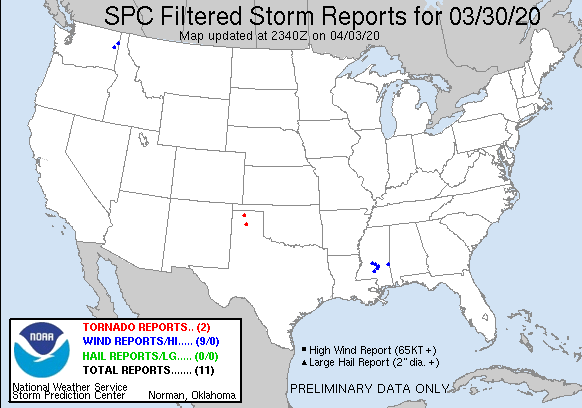
| Filtered Tornado Reports (CSV) (Raw Tornado CSV)(?) |
|---|
Time | | Location | County | State | Lat | Lon | Comments |
| 2222 | | 10 N PANTEX | CARSON | TX | 3547 | 10157 | THE TORNADO TOUCHED DOWN AT 0522 PM CDT APPROXIMATELY 10 MILES NORTH OF PANTEX. THE PATH LENGTH WAS 3.55 MILES AND THE PATH WIDTH WAS 50.0 YARDS. THE TORNADO LIFTED AT (AMA) |
| 2250 | | 10 N SUNRAY | SHERMAN | TX | 3616 | 10182 | THE TORNADO TOUCHED DOWN AT 0550 PM CDT APPROXIMATELY 10 MILES NORTH OF SUNRAY. THE PATH LENGTH WAS 0.21 MILE AND THE PATH WIDTH WAS 20.0 YARDS. THE TORNADO MOVED VERY (AMA) |
| Filtered Hail Reports (CSV) (Raw Hail CSV)(?) |
|---|
| No reports received |
| Filtered Wind Reports (CSV) (Raw Wind CSV)(?) |
|---|
Time | Speed | Location | County | State | Lat | Lon | Comments |
| 1833 | UNK | 1 WSW 5 MILE | SPOKANE | WA | 4773 | 11748 | REPORT VIA SOCIAL MEDIA OF TREE DOWNED ON HOUSE ON INDIAN TRAIL ROAD IN NORTH SPOKANE. EXACT LOCATION UNKNOWN. TIME ESTIMATED BY RADAR. (OTX) |
| 1856 | UNK | 1 ESE DIAMOND LAKE | PEND OREILLE | WA | 4812 | 11717 | REPORT OF DOWNED TREES AND POWERLINES ON GREEN ROAD IN THE DIAMOND LAKE AREA. (OTX) |
| 0514 | UNK | 1 W MANNASSA | CLARKE | MS | 3200 | 8860 | POWERLINE DOWNED ON COUNTY ROAD 511. (JAN) |
| 1030 | UNK | 1 SE ROBINHOOD | RANKIN | MS | 3220 | 8996 | TREE DOWN IN ROBINHOOD SUBDIVISION ON HERRINGTON COVE. (JAN) |
| 1046 | UNK | 3 NNE PUCKETT | RANKIN | MS | 3212 | 8977 | TREE DOWN ON JOHNS MAYTON ROAD NEAR PUCKETT. (JAN) |
| 1054 | UNK | 4 SSW POLKVILLE | SMITH | MS | 3214 | 8972 | TREE DOWN AT HWY 13 AND CR 142. (JAN) |
| 1135 | UNK | 4 NE MOUNT OLIVE | SMITH | MS | 3180 | 8960 | TREE DOWNED ON HIGHWAY 35 SOUTH OF MIZE. (JAN) |
| 1152 | UNK | 2 NE PRENTISS | JEFFERSON DAVIS | MS | 3161 | 8985 | TREE DOWNED ON GRANBY ROAD EAST OF PRENTISS. (JAN) |
| 1152 | UNK | 2 NNW CENTER RIDGE | SMITH | MS | 3197 | 8949 | TREE DOWN NEAR LIBERTY CHURCH ON HWY 37. TIME ESTIMATED BASED ON RADAR DATA. (JAN) |
| The Storm Reports page is organized based on reports received from 1200 UTC to 1159 UTC the next day. For example, storm report page for 20150430 covers reports from 20150430 at 1200 UTC to 20150501 at 1159 UTC. |
| Full report in comma-separated values (CSV) format and in KML format. |
| Full filtered report in comma-separated values (CSV) format and in KML format. |
| KML files are created with time-enabled placemarks compatible with Google Earth Time Slider. |
| Raw full report in comma-separated values (CSV) format. |
| Fields marked UNK are unknown. |
| All Times UTC. |
| Wind Gusts in MPH. |
| Hail Sizes in 1/100 of an Inch (175 = 1.75") |
| LAT/LON in decimal degrees to two decimals, see SPC FAQ for more info. |
| List of Weather Forecast Office 3-letter IDs appear in the report comments section. |
|
|
|
Top/Storm Reports/Home
|
|
|


 @NWSSPC