|
20190908's Storm Reports (20190908 1200 UTC - 20190909 1159 UTC) (Print Version)
|
< 190907 Reports
190909 Reports >
|
| Note: All Reports Are Considered Preliminary |
|
|
|
|
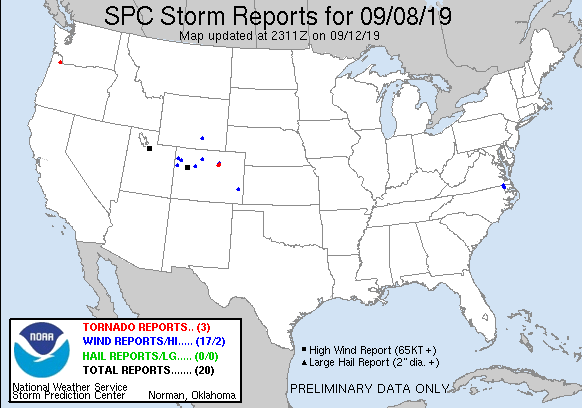
| Tornado Reports (CSV) (Raw Tornado CSV)(?) |
|---|
Time | | Location | County | State | Lat | Lon | Comments |
| 2342 | | 1 SW DENVER INTL AIRPOR | DENVER | CO | 3985 | 10469 | WEAK TORNADO THAT LASTED ABOUT A MINUTE. NO DAMAGE. (BOU) |
| 2354 | | 6 ESE LOCHBUIE | ADAMS | CO | 3999 | 10461 | LOCATION IS APPROXIMATE. (BOU) |
| 0144 | | 4 N ROCKCREEK | MULTNOMAH | OR | 4561 | 12287 | NWS STORM SURVEY CONFIRMED AN EF-0 TORNADO WITH WINDS TO 65 MPH. THE TOUCHDOWN OCCURRED IN FARMLAND AND DAMAGED CORN AND PUMPKIN FIELDS ... BARN DOORS ... 19 SOLAR PANELS (PQR) |
| Hail Reports (CSV) (Raw Hail CSV)(?) |
|---|
| No reports received |
| Wind Reports (CSV) (Raw Wind CSV)(?) |
|---|
Time | Speed | Location | County | State | Lat | Lon | Comments |
| 1815 | 59 | 1 NE RANGELY | RIO BLANCO | CO | 4010 | 10877 | AWOS STATION K4V0 RANGELY 2E. (GJT) |
| 1923 | 69 | 18 SE MASSADONA | RIO BLANCO | CO | 4002 | 10840 | MESONET STATION PIRC2 PINTO ... MASSADONA 18SE. (GJT) |
| 2000 | 79 | 3 ENE COTTONWOOD HEIGHT | SALT LAKE | UT | 4062 | 11175 | (SLC) |
| 2010 | 66 | 5 ENE COTTONWOOD HEIGHT | SALT LAKE | UT | 4063 | 11172 | (SLC) |
| 2010 | 63 | 5 NNW SNOWBIRD | SALT LAKE | UT | 4063 | 11170 | (SLC) |
| 2023 | 61 | 2 ESE GYPSUM | EAGLE | CO | 3963 | 10692 | AWOS STATION KEGE EAGLE COUNTY RGNL AIRPORT. (GJT) |
| 2120 | UNK | 2 SE GATESVILLE | GATES | NC | 3639 | 7673 | TREES DOWNED ALONG NC-37 AND FLAT BRANCH RD. (AKQ) |
| 2130 | 58 | 11 NNE KREMMLING | GRAND | CO | 4021 | 10633 | (BOU) |
| 2133 | UNK | 1 E GATES | GATES | NC | 3650 | 7676 | POWER LINES DOWNED ALONG GATES BANK RD. (AKQ) |
| 2136 | UNK | HANNA | CARBON | WY | 4187 | 10656 | RECEIVED REPORT VIA FACEBOOK OF A SHED BLOWN AWAY IN THE WIND AND A VIDEO OF A DETACHED TRAILER FLIPPED ON THE SIDE. TRAILER WAS 1/4 FULL. ESTIMATED WEIGHT 2400 LBS. ES (CYS) |
| 2234 | 58 | DOUGLAS PASS | GARFIELD | CO | 3960 | 10881 | MESONET STATION CO098 DOUGLAS PASS. (GJT) |
| 2345 | 58 | DENVER INTL AIRPORT | DENVER | CO | 3987 | 10467 | (BOU) |
| 2347 | 76 | 2 E RIFLE | GARFIELD | CO | 3953 | 10773 | ASOS STATION KRIL GARFIELD COUNTY RGNL AP. (GJT) |
| 2351 | 58 | 2 SE RIFLE | GARFIELD | CO | 3951 | 10775 | MESONET STATION RFEC2 RIFLE 2SE. (GJT) |
| 0000 | UNK | 4 NE LAMAR | PROWERS | CO | 3812 | 10256 | 5 INCH TREE LIMBS BROKE OFF THE TREES. SPOTTER ESTIMATES WIND SPEEDS WERE AROUND 60 MPH. (PUB) |
| 0011 | 68 | 4 S KEENESBURG | WELD | CO | 4005 | 10453 | (BOU) |
| 0145 | UNK | 6 WNW ST. JOHNS | MULTNOMAH | OR | 4561 | 12286 | STRONG THUNDERSTORM BROUGHT GUSTY WINDS AND A POSSIBLE TORNADO TO PLUMPERS PUMPKIN PATCH NEAR CORNELIUS PASS. DAMAGE REPORTED TO SOLAR PANELS ... A CORN MAZE ... AND A 25 X (PQR) |
|
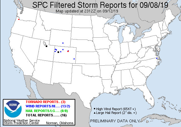
| Filtered Tornado Reports (CSV) (Raw Tornado CSV)(?) |
|---|
Time | | Location | County | State | Lat | Lon | Comments |
| 2342 | | 1 SW DENVER INTL AIRPOR | DENVER | CO | 3985 | 10469 | WEAK TORNADO THAT LASTED ABOUT A MINUTE. NO DAMAGE. (BOU) |
| 2354 | | 6 ESE LOCHBUIE | ADAMS | CO | 3999 | 10461 | LOCATION IS APPROXIMATE. (BOU) |
| 0144 | | 4 N ROCKCREEK | MULTNOMAH | OR | 4561 | 12287 | NWS STORM SURVEY CONFIRMED AN EF-0 TORNADO WITH WINDS TO 65 MPH. THE TOUCHDOWN OCCURRED IN FARMLAND AND DAMAGED CORN AND PUMPKIN FIELDS ... BARN DOORS ... 19 SOLAR PANELS (PQR) |
| Filtered Hail Reports (CSV) (Raw Hail CSV)(?) |
|---|
| No reports received |
| Filtered Wind Reports (CSV) (Raw Wind CSV)(?) |
|---|
Time | Speed | Location | County | State | Lat | Lon | Comments |
| 1815 | 59 | 1 NE RANGELY | RIO BLANCO | CO | 4010 | 10877 | AWOS STATION K4V0 RANGELY 2E. (GJT) |
| 1923 | 69 | 18 SE MASSADONA | RIO BLANCO | CO | 4002 | 10840 | MESONET STATION PIRC2 PINTO ... MASSADONA 18SE. (GJT) |
| 2000 | 79 | 3 ENE COTTONWOOD HEIGHT | SALT LAKE | UT | 4062 | 11175 | (SLC) |
| 2023 | 61 | 2 ESE GYPSUM | EAGLE | CO | 3963 | 10692 | AWOS STATION KEGE EAGLE COUNTY RGNL AIRPORT. (GJT) |
| 2120 | UNK | 2 SE GATESVILLE | GATES | NC | 3639 | 7673 | TREES DOWNED ALONG NC-37 AND FLAT BRANCH RD. (AKQ) |
| 2130 | 58 | 11 NNE KREMMLING | GRAND | CO | 4021 | 10633 | (BOU) |
| 2136 | UNK | HANNA | CARBON | WY | 4187 | 10656 | RECEIVED REPORT VIA FACEBOOK OF A SHED BLOWN AWAY IN THE WIND AND A VIDEO OF A DETACHED TRAILER FLIPPED ON THE SIDE. TRAILER WAS 1/4 FULL. ESTIMATED WEIGHT 2400 LBS. ES (CYS) |
| 2234 | 58 | DOUGLAS PASS | GARFIELD | CO | 3960 | 10881 | MESONET STATION CO098 DOUGLAS PASS. (GJT) |
| 2345 | 58 | DENVER INTL AIRPORT | DENVER | CO | 3987 | 10467 | (BOU) |
| 2347 | 76 | 2 E RIFLE | GARFIELD | CO | 3953 | 10773 | ASOS STATION KRIL GARFIELD COUNTY RGNL AP. (GJT) |
| 0000 | UNK | 4 NE LAMAR | PROWERS | CO | 3812 | 10256 | 5 INCH TREE LIMBS BROKE OFF THE TREES. SPOTTER ESTIMATES WIND SPEEDS WERE AROUND 60 MPH. (PUB) |
| 0011 | 68 | 4 S KEENESBURG | WELD | CO | 4005 | 10453 | (BOU) |
| 0145 | UNK | 6 WNW ST. JOHNS | MULTNOMAH | OR | 4561 | 12286 | STRONG THUNDERSTORM BROUGHT GUSTY WINDS AND A POSSIBLE TORNADO TO PLUMPERS PUMPKIN PATCH NEAR CORNELIUS PASS. DAMAGE REPORTED TO SOLAR PANELS ... A CORN MAZE ... AND A 25 X (PQR) |
| The Storm Reports page is organized based on reports received from 1200 UTC to 1159 UTC the next day. For example, storm report page for 20150430 covers reports from 20150430 at 1200 UTC to 20150501 at 1159 UTC. |
| Full report in comma-separated values (CSV) format and in KML format. |
| Full filtered report in comma-separated values (CSV) format and in KML format. |
| KML files are created with time-enabled placemarks compatible with Google Earth Time Slider. |
| Raw full report in comma-separated values (CSV) format. |
| Fields marked UNK are unknown. |
| All Times UTC. |
| Wind Gusts in MPH. |
| Hail Sizes in 1/100 of an Inch (175 = 1.75") |
| LAT/LON in decimal degrees to two decimals, see SPC FAQ for more info. |
| List of Weather Forecast Office 3-letter IDs appear in the report comments section. |
|
|
|
Top/Storm Reports/Home
|
|
|


 @NWSSPC