|
20190106's Storm Reports (20190106 1200 UTC - 20190107 1159 UTC) (Print Version)
|
< 190105 Reports
190107 Reports >
|
| Note: All Reports Are Considered Preliminary |
|
|
|
|
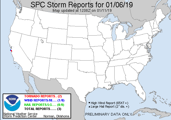
| Tornado Reports (CSV) (Raw Tornado CSV)(?) |
|---|
Time | | Location | County | State | Lat | Lon | Comments |
| 1959 | | 1 S SANTA CRUZ | SANTA CRUZ | CA | 3696 | 12204 | WATERSPOUT MOVED ONSHORE ALONG WEST CLIFF DRIVE ... JUST WEST OF WOODROW AVE. AS IT MOVED ONSHORE ... IT PICKED UP A CONSTRUCTION SIGN ... AND TOSSED IT INTO THE MAILBOX A (MTR) |
| 2019 | | 1 SE SANTA CRUZ | PZZ535 | CA | 3696 | 12202 | WATERSPOUT CROSSED THE SANTA CRUZ WHARF ... STRIKING THE DOLPHIN RESTAURANT AND REMOVING APPROXIMATELY 35 PERCENT OF ITS ROOF. THE TORNADO ALSO MOVED SEVERAL PICNIC TABL (MTR) |
| Hail Reports (CSV) (Raw Hail CSV)(?) |
|---|
| No reports received |
| Wind Reports (CSV) (Raw Wind CSV)(?) |
|---|
Time | Speed | Location | County | State | Lat | Lon | Comments |
| 1950 | UNK | 9 WSW BOULDER CREEK | SAN MATEO | CA | 3711 | 12229 | SEVERAL TREES SHOWED INDICATIONS OF SMALL AND LARGELIMB DAMAGE ALONG THE RIDGE LINE. ONE TREE MAY HAVE BEEN TOPPED. ESTIMATED PEAK WINDS OF 65 TO 70 MPH. (MTR) |
|
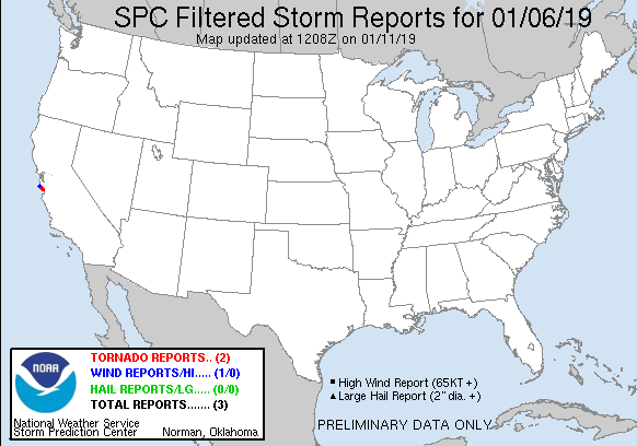
| Filtered Tornado Reports (CSV) (Raw Tornado CSV)(?) |
|---|
Time | | Location | County | State | Lat | Lon | Comments |
| 1959 | | 1 S SANTA CRUZ | SANTA CRUZ | CA | 3696 | 12204 | WATERSPOUT MOVED ONSHORE ALONG WEST CLIFF DRIVE ... JUST WEST OF WOODROW AVE. AS IT MOVED ONSHORE ... IT PICKED UP A CONSTRUCTION SIGN ... AND TOSSED IT INTO THE MAILBOX A (MTR) |
| 2019 | | 1 SE SANTA CRUZ | PZZ535 | CA | 3696 | 12202 | WATERSPOUT CROSSED THE SANTA CRUZ WHARF ... STRIKING THE DOLPHIN RESTAURANT AND REMOVING APPROXIMATELY 35 PERCENT OF ITS ROOF. THE TORNADO ALSO MOVED SEVERAL PICNIC TABL (MTR) |
| Filtered Hail Reports (CSV) (Raw Hail CSV)(?) |
|---|
| No reports received |
| Filtered Wind Reports (CSV) (Raw Wind CSV)(?) |
|---|
Time | Speed | Location | County | State | Lat | Lon | Comments |
| 1950 | UNK | 9 WSW BOULDER CREEK | SAN MATEO | CA | 3711 | 12229 | SEVERAL TREES SHOWED INDICATIONS OF SMALL AND LARGELIMB DAMAGE ALONG THE RIDGE LINE. ONE TREE MAY HAVE BEEN TOPPED. ESTIMATED PEAK WINDS OF 65 TO 70 MPH. (MTR) |
| The Storm Reports page is organized based on reports received from 1200 UTC to 1159 UTC the next day. For example, storm report page for 20150430 covers reports from 20150430 at 1200 UTC to 20150501 at 1159 UTC. |
| Full report in comma-separated values (CSV) format and in KML format. |
| Full filtered report in comma-separated values (CSV) format and in KML format. |
| KML files are created with time-enabled placemarks compatible with Google Earth Time Slider. |
| Raw full report in comma-separated values (CSV) format. |
| Fields marked UNK are unknown. |
| All Times UTC. |
| Wind Gusts in MPH. |
| Hail Sizes in 1/100 of an Inch (175 = 1.75") |
| LAT/LON in decimal degrees to two decimals, see SPC FAQ for more info. |
| List of Weather Forecast Office 3-letter IDs appear in the report comments section. |
|
|
|
Top/Storm Reports/Home
|
|
|


 @NWSSPC