|
20181004's Storm Reports (20181004 1200 UTC - 20181005 1159 UTC) (Print Version)
|
< 181003 Reports
181005 Reports >
|
| Note: All Reports Are Considered Preliminary |
|
|
|
|
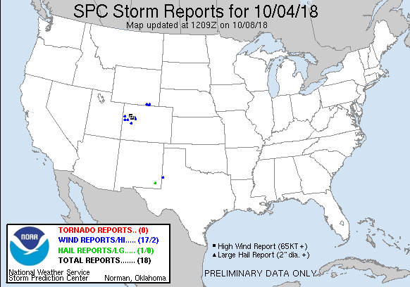
| Tornado Reports (CSV) (Raw Tornado CSV)(?) |
|---|
| No reports received |
| Hail Reports (CSV) (Raw Hail CSV)(?) |
|---|
Time | Size | Location | County | State | Lat | Lon | Comments |
| 0035 | 125 | 5 W HALFWAY | Eddy | NM | 3255 | 10382 | (MAF) |
| Wind Reports (CSV) (Raw Wind CSV)(?) |
|---|
Time | Speed | Location | County | State | Lat | Lon | Comments |
| 1531 | 65 | 1 WNW FRUITA | MESA | CO | 3916 | 10874 | WINDOW BROKEN BY A 1 INCH DIAMETER AND 3 FEET LONG TREE BRANCH. (GJT) |
| 1605 | 61 | 4 NE CAMEO | MESA | CO | 3920 | 10827 | (GJT) |
| 1605 | 64 | DOUGLAS PASS | GARFIELD | CO | 3960 | 10880 | (GJT) |
| 1631 | 81 | 3 SE RIO BLANCO | GARFIELD | CO | 3970 | 10793 | MESONET STATION CO126 ... RIO BLANCO 2ESE. (GJT) |
| 1641 | 82 | 3 ESE RIFLE | GARFIELD | CO | 3953 | 10772 | ASOS STATION RIL ... GARFIELD COUNTY RGNL AP. (GJT) |
| 1646 | UNK | 3 ESE RIFLE | GARFIELD | CO | 3953 | 10773 | CESSNA FLIPPED OVER AND A SIGN WAS BLOWN DOWN. (GJT) |
| 1652 | 70 | 3 NNW HOTCHKISS | DELTA | CO | 3885 | 10774 | MESONET STATION JAYC2 ... JAY ... HOTCHKISS 3NNW. (GJT) |
| 1654 | 67 | 1 WSW SILT | GARFIELD | CO | 3954 | 10767 | MESONET STATION CO084 ... SILT 1WSW. (GJT) |
| 1655 | 61 | SILT | GARFIELD | CO | 3955 | 10765 | (GJT) |
| 1710 | UNK | GLENWOOD SPRINGS | GARFIELD | CO | 3954 | 10733 | REPORT OF TREE LIMBS DOWN FROM THE GARFIELD COUNTY COMMUNICATIONS OFFICE. TIME ESTIMATED BY RADAR. (GJT) |
| 1715 | UNK | CARBONDALE | GARFIELD | CO | 3943 | 10725 | 2 FOOT DIAMETER COTTONWOOD TREE KNOCKED DOWN. A TOTAL 5 LARGE TREES DOWN AND ESTIMATED OVER 65 MPH WIND GUSTS AND HEAVY RAINFALL. (GJT) |
| 1915 | 62 | DOUGLAS PASS | GARFIELD | CO | 3960 | 10881 | MESONET STATION CO098 ... DOUGLAS PASS. (GJT) |
| 1920 | 58 | 18 SW LARAMIE | ALBANY | WY | 4113 | 10583 | (CYS) |
| 1955 | 58 | 9 W BUFORD | ALBANY | WY | 4111 | 10547 | WIND GUST MEASURED AT SUMMIT EAST WYDOT SENSOR (CYS) |
| 1955 | 60 | 6 WNW BUFORD | ALBANY | WY | 4114 | 10541 | THIS IS WYDOT SITE VEDAUWOO. (CYS) |
| 1957 | 60 | VEDAUWOO | ALBANY | WY | 4115 | 10540 | (CYS) |
| 2105 | 71 | 3 N PLAINS | YOAKUM | TX | 3323 | 10284 | (LUB) |
|
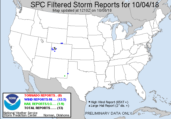
| Filtered Tornado Reports (CSV) (Raw Tornado CSV)(?) |
|---|
| No reports received |
| Filtered Hail Reports (CSV) (Raw Hail CSV)(?) |
|---|
Time | Size | Location | County | State | Lat | Lon | Comments |
| 0035 | 125 | 5 W HALFWAY | Eddy | NM | 3255 | 10382 | (MAF) |
| Filtered Wind Reports (CSV) (Raw Wind CSV)(?) |
|---|
Time | Speed | Location | County | State | Lat | Lon | Comments |
| 1531 | 65 | 1 WNW FRUITA | MESA | CO | 3916 | 10874 | WINDOW BROKEN BY A 1 INCH DIAMETER AND 3 FEET LONG TREE BRANCH. (GJT) |
| 1605 | 61 | 4 NE CAMEO | MESA | CO | 3920 | 10827 | (GJT) |
| 1605 | 64 | DOUGLAS PASS | GARFIELD | CO | 3960 | 10880 | (GJT) |
| 1631 | 81 | 3 SE RIO BLANCO | GARFIELD | CO | 3970 | 10793 | MESONET STATION CO126 ... RIO BLANCO 2ESE. (GJT) |
| 1641 | 82 | 3 ESE RIFLE | GARFIELD | CO | 3953 | 10772 | ASOS STATION RIL ... GARFIELD COUNTY RGNL AP. (GJT) |
| 1646 | UNK | 3 ESE RIFLE | GARFIELD | CO | 3953 | 10773 | CESSNA FLIPPED OVER AND A SIGN WAS BLOWN DOWN. (GJT) |
| 1652 | 70 | 3 NNW HOTCHKISS | DELTA | CO | 3885 | 10774 | MESONET STATION JAYC2 ... JAY ... HOTCHKISS 3NNW. (GJT) |
| 1710 | UNK | GLENWOOD SPRINGS | GARFIELD | CO | 3954 | 10733 | REPORT OF TREE LIMBS DOWN FROM THE GARFIELD COUNTY COMMUNICATIONS OFFICE. TIME ESTIMATED BY RADAR. (GJT) |
| 1915 | 62 | DOUGLAS PASS | GARFIELD | CO | 3960 | 10881 | MESONET STATION CO098 ... DOUGLAS PASS. (GJT) |
| 1920 | 58 | 18 SW LARAMIE | ALBANY | WY | 4113 | 10583 | (CYS) |
| 1955 | 60 | 6 WNW BUFORD | ALBANY | WY | 4114 | 10541 | THIS IS WYDOT SITE VEDAUWOO. (CYS) |
| 2105 | 71 | 3 N PLAINS | YOAKUM | TX | 3323 | 10284 | (LUB) |
| The Storm Reports page is organized based on reports received from 1200 UTC to 1159 UTC the next day. For example, storm report page for 20150430 covers reports from 20150430 at 1200 UTC to 20150501 at 1159 UTC. |
| Full report in comma-separated values (CSV) format and in KML format. |
| Full filtered report in comma-separated values (CSV) format and in KML format. |
| KML files are created with time-enabled placemarks compatible with Google Earth Time Slider. |
| Raw full report in comma-separated values (CSV) format. |
| Fields marked UNK are unknown. |
| All Times UTC. |
| Wind Gusts in MPH. |
| Hail Sizes in 1/100 of an Inch (175 = 1.75") |
| LAT/LON in decimal degrees to two decimals, see SPC FAQ for more info. |
| List of Weather Forecast Office 3-letter IDs appear in the report comments section. |
|
|
|
Top/Storm Reports/Home
|
|
|


 @NWSSPC