|
20180930's Storm Reports (20180930 1200 UTC - 20181001 1159 UTC) (Print Version)
|
< 180929 Reports
181001 Reports >
|
| Note: All Reports Are Considered Preliminary |
|
|
|
|
| Tornado Reports (CSV) (Raw Tornado CSV)(?) |
|---|
| No reports received |
| Hail Reports (CSV) (Raw Hail CSV)(?) |
|---|
| No reports received |
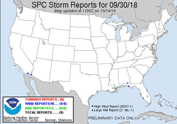
| Wind Reports (CSV) (Raw Wind CSV)(?) |
|---|
Time | Speed | Location | County | State | Lat | Lon | Comments |
| 1954 | UNK | 2 SE YUMA | YUMA | AZ | 3268 | 11460 | **DELAYED REPORT ... FOUR MOBILE HOMES LOST AWNINGS WITH TREE LIMBS DOWN DUE TO MICROBURST. TIME ESTIMATED FROM RADAR. (PSR) |
| 2007 | UNK | 1 S BAYOU GEORGE | BAY | FL | 3025 | 8554 | 6 TREES DOWN ON A PROPERTY OFF JOHN PITTS ROAD IN THE BAYOU GEORGE AREA. REPORT VIA SOCIAL MEDIA WITH VIDEO. (TAE) |
| 2008 | UNK | 2 SSW BAYOU GEORGE | BAY | FL | 3024 | 8555 | MULTIPLE TREES DOWN IN A PASTURE OFF NADINE ROAD. ONE TREE FELL ON A FENCE. REPORT VIA SOCIAL MEDIA. (TAE) |
| 2010 | UNK | BRANNONVILLE | BAY | FL | 3023 | 8558 | FENCES AND TREES BLOWN DOWN IN THE BYLSMA MANOR AREA. REPORTED VIA SOCIAL MEDIA. (TAE) |
| 2012 | UNK | 1 SE PFN-BAY COUNTY AIR | BAY | FL | 3020 | 8567 | DAMAGE TO FENCING IN THE FOREST PARK AREA REPORTED VIA SOCIAL MEDIA. (TAE) |
| 2014 | UNK | PANAMA CITY | BAY | FL | 3018 | 8566 | SEVERAL TREES DOWN IN PANAMA CITY. MULTIPLE POWER LINES DOWN. TIME ESTIMATED BY RADAR. NICKEL SIZE HAIL ALSO REPORTED NORTH OF DOWNTOWN ON US-231. (TAE) |
| 2144 | UNK | GENEVA | GENEVA | AL | 3104 | 8587 | A COUPLE OF TREES DOWN IN GENEVA. TIME ESTIMATED BY RADAR. REPORT RELAYED THROUGH SOCIAL MEDIA. (TAE) |
| 0013 | UNK | SEELEY | IMPERIAL | CA | 3279 | 11568 | LARGE ~4 IN. TREE BRANCHES ON THE HIGHWAY IN SEELEY CA WITH 0 MI. VSBY. IN HEAVY RAIN. (PSR) |
| 0024 | 59 | 3 N SEELEY | IMPERIAL | CA | 3283 | 11567 | DELAYED REPORT. ASOS STATION NJK ... NAVAL AIR FACILITY. (PSR) |
|
| Filtered Tornado Reports (CSV) (Raw Tornado CSV)(?) |
|---|
| No reports received |
| Filtered Hail Reports (CSV) (Raw Hail CSV)(?) |
|---|
| No reports received |
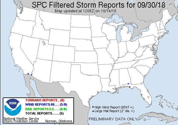
| Filtered Wind Reports (CSV) (Raw Wind CSV)(?) |
|---|
Time | Speed | Location | County | State | Lat | Lon | Comments |
| 1954 | UNK | 2 SE YUMA | YUMA | AZ | 3268 | 11460 | **DELAYED REPORT ... FOUR MOBILE HOMES LOST AWNINGS WITH TREE LIMBS DOWN DUE TO MICROBURST. TIME ESTIMATED FROM RADAR. (PSR) |
| 2007 | UNK | 1 S BAYOU GEORGE | BAY | FL | 3025 | 8554 | 6 TREES DOWN ON A PROPERTY OFF JOHN PITTS ROAD IN THE BAYOU GEORGE AREA. REPORT VIA SOCIAL MEDIA WITH VIDEO. (TAE) |
| 2144 | UNK | GENEVA | GENEVA | AL | 3104 | 8587 | A COUPLE OF TREES DOWN IN GENEVA. TIME ESTIMATED BY RADAR. REPORT RELAYED THROUGH SOCIAL MEDIA. (TAE) |
| 0013 | UNK | SEELEY | IMPERIAL | CA | 3279 | 11568 | LARGE ~4 IN. TREE BRANCHES ON THE HIGHWAY IN SEELEY CA WITH 0 MI. VSBY. IN HEAVY RAIN. (PSR) |
| 0024 | 59 | 3 N SEELEY | IMPERIAL | CA | 3283 | 11567 | DELAYED REPORT. ASOS STATION NJK ... NAVAL AIR FACILITY. (PSR) |
| The Storm Reports page is organized based on reports received from 1200 UTC to 1159 UTC the next day. For example, storm report page for 20150430 covers reports from 20150430 at 1200 UTC to 20150501 at 1159 UTC. |
| Full report in comma-separated values (CSV) format and in KML format. |
| Full filtered report in comma-separated values (CSV) format and in KML format. |
| KML files are created with time-enabled placemarks compatible with Google Earth Time Slider. |
| Raw full report in comma-separated values (CSV) format. |
| Fields marked UNK are unknown. |
| All Times UTC. |
| Wind Gusts in MPH. |
| Hail Sizes in 1/100 of an Inch (175 = 1.75") |
| LAT/LON in decimal degrees to two decimals, see SPC FAQ for more info. |
| List of Weather Forecast Office 3-letter IDs appear in the report comments section. |
|
|
|
Top/Storm Reports/Home
|
|
|


 @NWSSPC