|
20180225's Storm Reports (20180225 1200 UTC - 20180226 1159 UTC) (Print Version)
|
< 180224 Reports
180226 Reports >
|
| Note: All Reports Are Considered Preliminary |
|
|
|
|
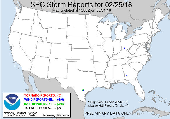
| Tornado Reports (CSV) (Raw Tornado CSV)(?) |
|---|
| No reports received |
| Hail Reports (CSV) (Raw Hail CSV)(?) |
|---|
Time | Size | Location | County | State | Lat | Lon | Comments |
| 1210 | 100 | FALLS CITY | KARNES | TX | 2898 | 9802 | (EWX) |
| 1220 | 150 | 7 W FALLS CITY | WILSON | TX | 2897 | 9814 | LOCAL PUBLIC REPORTED PING PONG SIZED HAIL. (EWX) |
| 1245 | 100 | 3 ENE CESTOHOWA | KARNES | TX | 2902 | 9788 | PUBLIC REPORTED 1 INCH HAIL OBSERVED. (EWX) |
| Wind Reports (CSV) (Raw Wind CSV)(?) |
|---|
Time | Speed | Location | County | State | Lat | Lon | Comments |
| 1232 | UNK | 2 SSE FALLS CITY | KARNES | TX | 2895 | 9801 | THUNDERSTORM WINDS BLEW OVER A GRAIN BIN AND SOME YARD FIXTURES. TIME ESTIMATED WITH RADAR. (EWX) |
| 1235 | UNK | 2 SSE CESTOHOWA | KARNES | TX | 2898 | 9792 | KARNES ELECTRIC CO-OP REPORTED POWER LINES DOWN. (EWX) |
| 1815 | UNK | 4 SSW CROXTON CROSSROAD | SUMTER | GA | 3191 | 8435 | CARPORT LOCATED AT A RESIDENCE OFF BOO COSBY ROAD WAS DAMAGED WHEN RADAR-ESTIMATED 30KT WINDS MOVED OVER THE AREA. (FFC) |
| 0205 | UNK | 1 WSW LYNCHBURG | CLINTON | OH | 3924 | 8381 | SOCIAL MEDIA REPORT OF 25-30 FT FLAG POLE BENT OVER ... GARDEN WINDMILL KNOCKED DOWN ... AND VAN WINDOW BROKEN FROM FLYING DEBRIS. TIME ESTIMATED FROM RADAR. (ILN) |
|
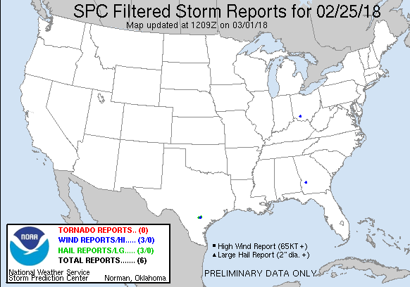
| Filtered Tornado Reports (CSV) (Raw Tornado CSV)(?) |
|---|
| No reports received |
| Filtered Hail Reports (CSV) (Raw Hail CSV)(?) |
|---|
Time | Size | Location | County | State | Lat | Lon | Comments |
| 1210 | 100 | FALLS CITY | KARNES | TX | 2898 | 9802 | (EWX) |
| 1220 | 150 | 7 W FALLS CITY | WILSON | TX | 2897 | 9814 | LOCAL PUBLIC REPORTED PING PONG SIZED HAIL. (EWX) |
| 1245 | 100 | 3 ENE CESTOHOWA | KARNES | TX | 2902 | 9788 | PUBLIC REPORTED 1 INCH HAIL OBSERVED. (EWX) |
| Filtered Wind Reports (CSV) (Raw Wind CSV)(?) |
|---|
Time | Speed | Location | County | State | Lat | Lon | Comments |
| 1232 | UNK | 2 SSE FALLS CITY | KARNES | TX | 2895 | 9801 | THUNDERSTORM WINDS BLEW OVER A GRAIN BIN AND SOME YARD FIXTURES. TIME ESTIMATED WITH RADAR. (EWX) |
| 1815 | UNK | 4 SSW CROXTON CROSSROAD | SUMTER | GA | 3191 | 8435 | CARPORT LOCATED AT A RESIDENCE OFF BOO COSBY ROAD WAS DAMAGED WHEN RADAR-ESTIMATED 30KT WINDS MOVED OVER THE AREA. (FFC) |
| 0205 | UNK | 1 WSW LYNCHBURG | CLINTON | OH | 3924 | 8381 | SOCIAL MEDIA REPORT OF 25-30 FT FLAG POLE BENT OVER ... GARDEN WINDMILL KNOCKED DOWN ... AND VAN WINDOW BROKEN FROM FLYING DEBRIS. TIME ESTIMATED FROM RADAR. (ILN) |
| The Storm Reports page is organized based on reports received from 1200 UTC to 1159 UTC the next day. For example, storm report page for 20150430 covers reports from 20150430 at 1200 UTC to 20150501 at 1159 UTC. |
| Full report in comma-separated values (CSV) format and in KML format. |
| Full filtered report in comma-separated values (CSV) format and in KML format. |
| KML files are created with time-enabled placemarks compatible with Google Earth Time Slider. |
| Raw full report in comma-separated values (CSV) format. |
| Fields marked UNK are unknown. |
| All Times UTC. |
| Wind Gusts in MPH. |
| Hail Sizes in 1/100 of an Inch (175 = 1.75") |
| LAT/LON in decimal degrees to two decimals, see SPC FAQ for more info. |
| List of Weather Forecast Office 3-letter IDs appear in the report comments section. |
|
|
|
Top/Storm Reports/Home
|
|
|


 @NWSSPC