|
20160918's Storm Reports (1200 UTC - 1159 UTC) (Print Version)
|
< 160917 Reports
160919 Reports >
|
| Note: All Reports Are Considered Preliminary |
|
|
|
|
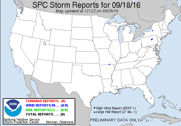
| Tornado Reports (CSV) (Raw Tornado CSV)(?) |
|---|
| No reports received |
| Hail Reports (CSV) (Raw Hail CSV)(?) |
|---|
| No reports received |
| Wind Reports (CSV) (Raw Wind CSV)(?) |
|---|
Time | Speed | Location | County | State | Lat | Lon | Comments |
| 2040 | UNK | 1 WSW THAYER | OREGON | MO | 3652 | 9156 | TREES DOWN 1 MILE WEST OF THAYER AT US HIGHWAY 142. REPORTED VIA PUBLIC ON SOCIAL MEDIA. (SGF) |
| 2227 | UNK | ELIMSPORT | LYCOMING | PA | 4113 | 7701 | MULTIPLE POLES DOWN. (CTP) |
| 2230 | UNK | ELIMSPORT | LYCOMING | PA | 4113 | 7701 | LARGE TREE DOWN. (CTP) |
| 2245 | UNK | MONTGOMERY | LYCOMING | PA | 4117 | 7688 | STRAIGHT LINE WINDS ESTIMATED NEAR 80 MPH KNOCKED DOWN NUMEROUS TREES AND PRODUCED MINOR STRUCTURAL DAMAGE NEAR MONTGOMERY. (CTP) |
| 2255 | UNK | MUNCY | LYCOMING | PA | 4120 | 7679 | A WET MICROBURST PRODCUED STRAIGHT-LINE WINDS ESTIMATED AT 90-100 MPH ... KNOCKING DOWN NUMEROUS TREES AND WIRES IN MUNCY. THREE BUILDINGS HAD SIGNIFICANT ROOF DAMAGE. (CTP) |
| 2300 | UNK | MUNCY | LYCOMING | PA | 4120 | 7679 | MULTIPLE LINES DOWN. (CTP) |
| 2307 | UNK | CONSTANTIA | OSWEGO | NY | 4325 | 7600 | SEVERAL TREES AND LINES DOWN ... INCLUDING ONE LARGE TREE FALLING ON A HOME. (BUF) |
| 2310 | UNK | MUNCY | LYCOMING | PA | 4120 | 7679 | WINDOWS BLOWN OUT. (CTP) |
|

| Filtered Tornado Reports (CSV) (Raw Tornado CSV)(?) |
|---|
| No reports received |
| Filtered Hail Reports (CSV) (Raw Hail CSV)(?) |
|---|
| No reports received |
| Filtered Wind Reports (CSV) (Raw Wind CSV)(?) |
|---|
Time | Speed | Location | County | State | Lat | Lon | Comments |
| 2040 | UNK | 1 WSW THAYER | OREGON | MO | 3652 | 9156 | TREES DOWN 1 MILE WEST OF THAYER AT US HIGHWAY 142. REPORTED VIA PUBLIC ON SOCIAL MEDIA. (SGF) |
| 2227 | UNK | ELIMSPORT | LYCOMING | PA | 4113 | 7701 | MULTIPLE POLES DOWN. (CTP) |
| 2245 | UNK | MONTGOMERY | LYCOMING | PA | 4117 | 7688 | MULTIPLE TREES DOWN. (CTP) |
| 2300 | UNK | MUNCY | LYCOMING | PA | 4120 | 7679 | MULTIPLE LINES DOWN. (CTP) |
| 2307 | UNK | CONSTANTIA | OSWEGO | NY | 4325 | 7600 | SEVERAL TREES AND LINES DOWN ... INCLUDING ONE LARGE TREE FALLING ON A HOME. (BUF) |
| Full report in comma-separated values (CSV) format and in KML format. |
| Full filtered report in comma-separated values (CSV) format and in KML format. |
| KML files are created with time-enabled placemarks compatible with Google Earth Time Slider. |
| Raw full report in comma-separated values (CSV) format |
| Fields marked UNK are unknown |
| All Times UTC |
| Wind Gusts in MPH |
| Hail Sizes in 1/100 of an Inch (175 = 1.75") |
| LAT/LON in decimal degrees to two decimals, see SPC FAQ for more info |
| List of Weather Forecast Office 3-letter IDs appear in the report comments section |
|
|
|
Top/Storm Reports/Home
|
|
|


 @NWSSPC