|
20160418's Storm Reports (1200 UTC - 1159 UTC) (Print Version)
|
< 160417 Reports
160419 Reports >
|
| Note: All Reports Are Considered Preliminary |
|
|
|
|
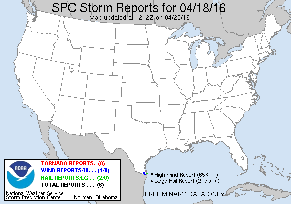
| Tornado Reports (CSV) (Raw Tornado CSV)(?) |
|---|
| No reports received |
| Hail Reports (CSV) (Raw Hail CSV)(?) |
|---|
Time | Size | Location | County | State | Lat | Lon | Comments |
| 0145 | 100 | SOUTH PADRE ISLAND | CAMERON | TX | 2608 | 9718 | CITIZEN VIA SOCIAL MEDIA REPORTS QUARTER-SIZE HAIL AT WHATABURGER LOCATION ON SOUTH PADRE ISLAND. (BRO) |
| 0148 | 100 | SOUTH PADRE ISLAND | CAMERON | TX | 2608 | 9718 | CITIZEN VIA SOCIAL MEDIA REPORTS QUARTER-SIZE HAIL ON SOUTH PADRE ISLAND. (BRO) |
| Wind Reports (CSV) (Raw Wind CSV)(?) |
|---|
Time | Speed | Location | County | State | Lat | Lon | Comments |
| 0316 | 58 | HARLINGEN | CAMERON | TX | 2620 | 9769 | (BRO) |
| 0323 | UNK | HARLINGEN | CAMERON | TX | 2620 | 9769 | HARLINGEN POLICE DEPARTMENT REPORTS POWERLINES DOWN AT 809 WEST HANSON ... 1307 NORTH ANN STREET ... 1506 SOUTH G STREET ... 629 NORTH 13TH STREET ... THE INTERSECTIONS OF TYLE (BRO) |
| 0356 | UNK | BROWNSVILLE | CAMERON | TX | 2593 | 9748 | BROWNSVILLE POLICE REPORTED THREE ELECTICAL POLES DOWN ALONG U.S. HWY 281. (BRO) |
| 0528 | UNK | BROWNSVILLE | CAMERON | TX | 2593 | 9748 | NWS EMPLOYEE REPORTS 8 INCH DIAMETER TREE LIMB PARTIALLY BLOCKING THE ROAD NEAR THE INTERSECTION OF JAIME J ZAPATA AND RAY DAVID DRIVE. (BRO) |
|
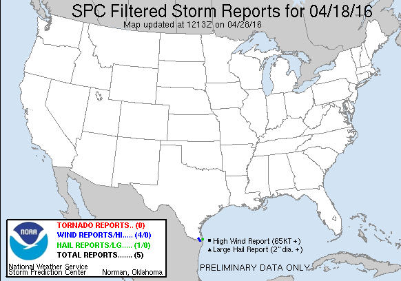
| Filtered Tornado Reports (CSV) (Raw Tornado CSV)(?) |
|---|
| No reports received |
| Filtered Hail Reports (CSV) (Raw Hail CSV)(?) |
|---|
Time | Size | Location | County | State | Lat | Lon | Comments |
| 0148 | 100 | SOUTH PADRE ISLAND | CAMERON | TX | 2608 | 9718 | CITIZEN VIA SOCIAL MEDIA REPORTS QUARTER-SIZE HAIL ON SOUTH PADRE ISLAND. (BRO) |
| Filtered Wind Reports (CSV) (Raw Wind CSV)(?) |
|---|
Time | Speed | Location | County | State | Lat | Lon | Comments |
| 0316 | 58 | HARLINGEN | CAMERON | TX | 2620 | 9769 | (BRO) |
| 0323 | UNK | HARLINGEN | CAMERON | TX | 2620 | 9769 | HARLINGEN POLICE DEPARTMENT REPORTS POWERLINES DOWN AT 809 WEST HANSON ... 1307 NORTH ANN STREET ... 1506 SOUTH G STREET ... 629 NORTH 13TH STREET ... THE INTERSECTIONS OF TYLE (BRO) |
| 0356 | UNK | BROWNSVILLE | CAMERON | TX | 2593 | 9748 | BROWNSVILLE POLICE REPORTED THREE ELECTICAL POLES DOWN ALONG U.S. HWY 281. (BRO) |
| 0528 | UNK | BROWNSVILLE | CAMERON | TX | 2593 | 9748 | NWS EMPLOYEE REPORTS 8 INCH DIAMETER TREE LIMB PARTIALLY BLOCKING THE ROAD NEAR THE INTERSECTION OF JAIME J ZAPATA AND RAY DAVID DRIVE. (BRO) |
| Full report in comma-separated values (CSV) format and in KML format. |
| Full filtered report in comma-separated values (CSV) format and in KML format. |
| KML files are created with time-enabled placemarks compatible with Google Earth Time Slider. |
| Raw full report in comma-separated values (CSV) format |
| Fields marked UNK are unknown |
| All Times UTC |
| Wind Gusts in MPH |
| Hail Sizes in 1/100 of an Inch (175 = 1.75") |
| LAT/LON in decimal degrees to two decimals, see SPC FAQ for more info |
| List of Weather Forecast Office 3-letter IDs appear in the report comments section |
|
|
|
Top/Storm Reports/Home
|
|
|


 @NWSSPC