| Tornado Reports (CSV) (Raw Tornado CSV)(?) |
|---|
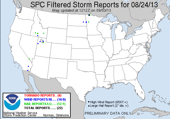
| No reports received |
| Hail Reports (CSV) (Raw Hail CSV)(?) |
|---|
Time | Size | Location | County | State | Lat | Lon | Comments |
| 1930 | 100 | 3 NW SANDY VALLEY | CLARK | NV | 3583 | 11565 | REPORT VIA FACEBOOK (VEF) |
| 2015 | 100 | EAGLE MTN | RIVERSIDE | CA | 3385 | 11548 | DELAYED REPORT ... APPROX 1 INCH HAIL OCCURRED FOR 30 MINUTES (PSR) |
| 2120 | 100 | 5 N JEROME | JEROME | ID | 4280 | 11452 | RELAYED THROUGH MEDIA. (BOI) |
| 2144 | 100 | GLENNS FERRY | ELMORE | ID | 4295 | 11530 | STRONG WINDS. REPORT RELAYED BY MEDIA. (BOI) |
| 2151 | 100 | SHOSHONE | LINCOLN | ID | 4294 | 11440 | (PIH) |
| 2151 | 100 | BLACKFOOT | BINGHAM | ID | 4319 | 11235 | UP TO 1 INCH HAIL REPORTED (PIH) |
| 2257 | 100 | SOUTH SALT LAKE | SALT LAKE | UT | 4071 | 11190 | (SLC) |
| 2321 | 100 | LAYTON | DAVIS | UT | 4108 | 11196 | MANY REPORTS OF NICKEL TO QUARTER SIZED HAIL (SLC) |
| 0015 | 100 | 7 S WARROAD | ROSEAU | MN | 4881 | 9532 | (FGF) |
| 0040 | 200 | 4 S SALOL | ROSEAU | MN | 4881 | 9557 | PUBLIC FACEBOOK REPORT RELAYED VIA MEDIA PARTNER. (FGF) |
| 0110 | 100 | 2 SW WARROAD | ROSEAU | MN | 4889 | 9535 | QUARTER OR SLIGHTLY LARGER SIZED HAIL JUST AFTER 8 PM (FGF) |
| 0115 | 150 | 7 WSW WARROAD | ROSEAU | MN | 4887 | 9546 | INFORMATION PASSED TO NWS VIA RELATIVES (FGF) |
| 0955 | 100 | 1 E CALLAWAY | BECKER | MN | 4698 | 9589 | ESTIMATED HAIL OF AT LEAST QUARTER SIZE. SEVERAL BRANCHES DOWN. (FGF) |
| Wind Reports (CSV) (Raw Wind CSV)(?) |
|---|
Time | Speed | Location | County | State | Lat | Lon | Comments |
| 2110 | 64 | 23 NE IBAPAH | TOOELE | UT | 4028 | 11370 | WEST SALT FLATS SENSOR DPG26 (SLC) |
| 2130 | UNK | EAGLE MTN | RIVERSIDE | CA | 3385 | 11548 | DELAYED REPORT ... STORM CONTINUED UNTIL 330 PM. MULTIPLE TREES AND POWER LINES BLOWN DOWN (PSR) |
| 2225 | 64 | 15 NNE KNOLLS | TOOELE | UT | 4091 | 11315 | DIDDLE KNOLL SENSOR DPG27 (SLC) |
| 2240 | 60 | HOLTVILLE | IMPERIAL | CA | 3281 | 11537 | DELAYED REPORT ... GUSTY WINDS FOR MORE THAN AN HOUR IN HOLTVILLE. (PSR) |
| 2321 | UNK | LAYTON | DAVIS | UT | 4108 | 11196 | TREES DOWN ON FAIRFIELD ROAD (SLC) |
| 2343 | 61 | 8 N MAGIC MOUNTAIN SKI | TWIN FALLS | ID | 4231 | 11432 | TRAIL GULCH RAWS AT 5700 FEET. (BOI) |
| 0037 | UNK | 3 E ROSEAU | ROSEAU | MN | 4885 | 9570 | REPORT OF MULTIPLE 20-30 FT TREES DOWN. TIME ESTIMATED FROM RADAR. (FGF) |
| 0840 | UNK | 6 NE VALLEY CITY | BARNES | ND | 4698 | 9792 | HAIL AND WIND CAUSED SOME CROP DAMAGE. HAIL SIZE UNKNOWN. (FGF) |
| 0853 | 59 | FARGO | CASS | ND | 4688 | 9682 | (FGF) |
| 0855 | UNK | 2 W KRAGNES | CLAY | MN | 4699 | 9679 | GRAIN BIN UNDER CONSTRUCTION WAS BLOWN OVER. LARGE HAIL TO NEAR GOLFBALL SIZE ALSO REPORTED VIA KVLY FACEBOOK PAGE. (FGF) |


 @NWSSPC