|
20130820's Storm Reports (1200 UTC - 1159 UTC) (Print Version)
|
< 130819 Reports
130821 Reports >
|
| Note: All Reports Are Considered Preliminary |
|
|
|
|
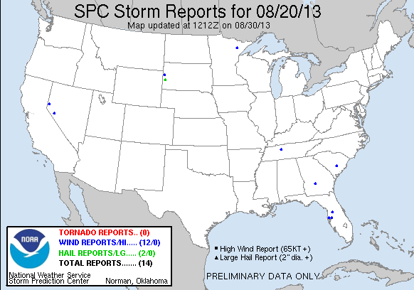
| Tornado Reports (CSV) (Raw Tornado CSV)(?) |
|---|
| No reports received |
| Hail Reports (CSV) (Raw Hail CSV)(?) |
|---|
Time | Size | Location | County | State | Lat | Lon | Comments |
| 2043 | 125 | 3 SSE SILVER CITY | PENNINGTON | SD | 4405 | 10354 | (UNR) |
| 2245 | 100 | 2 NNW SAINT ONGE | LAWRENCE | SD | 4458 | 10375 | (UNR) |
| Wind Reports (CSV) (Raw Wind CSV)(?) |
|---|
Time | Speed | Location | County | State | Lat | Lon | Comments |
| 2015 | UNK | 4 S SANTEE | ORANGEBURG | SC | 3342 | 8049 | COUNTY SHERIFF REPORTS A COUPLE OF TREES DOWN ALONG VANCE ROAD NEAR INTERSTATE 95. (CAE) |
| 2130 | UNK | 5 N BRANDON | HILLSBOROUGH | FL | 2801 | 8228 | REPORT OF 2 TREES DOWN ACROSS THE ROAD. TIME ESTIMATED BY RADAR. (TBW) |
| 2132 | UNK | SEFFNER | HILLSBOROUGH | FL | 2800 | 8227 | BAY NEWS 9 RELAYED A REPORT OF A DOWNED TREE ON HILLSBOROUGH AVENUE IN SEFFNER. TIME ESTIMATED OFF RADAR AT 532 PM EDT. (TBW) |
| 2215 | UNK | 5 NW TAMPA INTERNATIONA | HILLSBOROUGH | FL | 2803 | 8258 | BAY NEWS 9 RELAYED A SOCIAL MEDIA REPORT OF A DOWNED TREE IN THE MEADOWBROOK VILLAGE NEIGHBORHOOD IN TOWN N COUNTRY. (TBW) |
| 2245 | UNK | WEBSTER | SUMTER | FL | 2861 | 8205 | PUBLIC REPORTED DAMAGE TO AN ALUMINUM ROOF ... A SIGN BLOWN DOWN ... AND A SMALL BOAT FLIPPED BY THUNDERSTORM WINDS IN WEBSTER. RADAR ESTIMATED TIME OF 645 PM EDT. (TBW) |
| 2245 | 60 | 2 NNW SAINT ONGE | LAWRENCE | SD | 4458 | 10375 | SMALL BRANCHES BEING BLOWN OFF TREES (UNR) |
| 2249 | 62 | 2 NNW SAINT ONGE | LAWRENCE | SD | 4458 | 10375 | SMALL BROKEN TREE BRANCHES. (UNR) |
| 0059 | UNK | PITTS | WILCOX | GA | 3194 | 8354 | MIDDLE GEORGIA EMC REPORTS A FEW POWER OUTAGES IN WILCOX COUNTY. MOST OF THE ISSUES WERE CAUSED BY DOWNED LIMBS. ALSO WILCOX COUNTY 911 RELAYED A REPORT OF A TREE DOWN (FFC) |
| 0200 | UNK | 2 SSW DICKSON | DICKSON | TN | 3605 | 8739 | MULTIPLE TREES DOWN IN AND AROUND THE CITY OF DICKSON INCLUDING ONE DOWN ON A CAR. (OHX) |
| 0200 | 60 | WALKER LAKE | MINERAL | NV | 3869 | 11874 | OUTFLOW GUST REPORTED AT NDOT WIND SENSOR. (REV) |
| 0340 | UNK | NE SPARKS | WASHOE | NV | 3954 | 11974 | 30 FEET OF WOOD FENCE AND 3 INCH DIAMETER APPLE TREE BLOWN OVER. ESTIMATED GUST 50 MPH. (REV) |
| 0900 | UNK | 5 SW BIWABIK | ST. LOUIS | MN | 4748 | 9243 | APPROXIMATELY 15 TREES DOWN IN A BIG SWATH. SOME TREES SNAPPED AND SOME BLOWN COMPLETELY OVER AND UPROOTED. TIME IS APPROXIMATE AND MAY BE ADJUSTED. (DLH) |
|
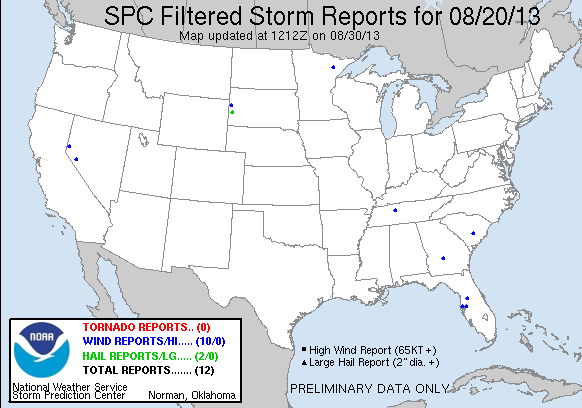
| Filtered Tornado Reports (CSV) (Raw Tornado CSV)(?) |
|---|
| No reports received |
| Filtered Hail Reports (CSV) (Raw Hail CSV)(?) |
|---|
Time | Size | Location | County | State | Lat | Lon | Comments |
| 2043 | 125 | 3 SSE SILVER CITY | PENNINGTON | SD | 4405 | 10354 | (UNR) |
| 2245 | 100 | 2 NNW SAINT ONGE | LAWRENCE | SD | 4458 | 10375 | (UNR) |
| Filtered Wind Reports (CSV) (Raw Wind CSV)(?) |
|---|
Time | Speed | Location | County | State | Lat | Lon | Comments |
| 2015 | UNK | 4 S SANTEE | ORANGEBURG | SC | 3342 | 8049 | COUNTY SHERIFF REPORTS A COUPLE OF TREES DOWN ALONG VANCE ROAD NEAR INTERSTATE 26. (CAE) |
| 2130 | UNK | 5 N BRANDON | HILLSBOROUGH | FL | 2801 | 8228 | REPORT OF 2 TREES DOWN ACROSS THE ROAD. TIME ESTIMATED BY RADAR. (TBW) |
| 2215 | UNK | 5 NW TAMPA INTERNATIONA | HILLSBOROUGH | FL | 2803 | 8258 | BAY NEWS 9 RELAYED A SOCIAL MEDIA REPORT OF A DOWNED TREE IN THE MEADOWBROOK VILLAGE NEIGHBORHOOD IN TOWN N COUNTRY. (TBW) |
| 2245 | UNK | WEBSTER | SUMTER | FL | 2861 | 8205 | PUBLIC REPORTED DAMAGE TO AN ALUMINUM ROOF ... A SIGN BLOWN DOWN ... AND A SMALL BOAT FLIPPED BY THUNDERSTORM WINDS IN WEBSTER. RADAR ESTIMATED TIME OF 645 PM EDT. (TBW) |
| 2249 | 62 | 2 NNW SAINT ONGE | LAWRENCE | SD | 4458 | 10375 | SMALL BROKEN TREE BRANCHES. (UNR) |
| 0059 | UNK | PITTS | WILCOX | GA | 3194 | 8354 | MIDDLE GEORGIA EMC REPORTS A FEW POWER OUTAGES IN WILCOX COUNTY. MOST OF THE ISSUES WERE CAUSED BY DOWNED LIMBS. ALSO WILCOX COUNTY 911 RELAYED A REPORT OF A TREE DOWN (FFC) |
| 0200 | UNK | 2 SSW DICKSON | DICKSON | TN | 3605 | 8739 | TREE BLOWN DOWN ALONG EAST PINEY ROAD ... SOUTHERN DICKSON COUNTY. (OHX) |
| 0200 | 60 | WALKER LAKE | MINERAL | NV | 3869 | 11874 | OUTFLOW GUST REPORTED AT NDOT WIND SENSOR. (REV) |
| 0340 | UNK | NE SPARKS | WASHOE | NV | 3954 | 11974 | 30 FEET OF WOOD FENCE AND 3 INCH DIAMETER APPLE TREE BLOWN OVER. ESTIMATED GUST 50 MPH. (REV) |
| 0900 | UNK | 5 SW BIWABIK | ST. LOUIS | MN | 4748 | 9243 | APPROXIMATELY 15 TREES DOWN IN A BIG SWATH. SOME TREES SNAPPED AND SOME BLOWN COMPLETELY OVER AND UPROOTED. TIME IS APPROXIMATE AND MAY BE ADJUSTED. (DLH) |
| Full report in comma-separated values (CSV) format and in KML format. |
| Full filtered report in comma-separated values (CSV) format and in KML format. |
| KML files are created with time-enabled placemarks compatible with Google Earth Time Slider. |
| Raw full report in comma-separated values (CSV) format |
| Fields marked UNK are unknown |
| All Times UTC |
| Wind Gusts in MPH |
| Hail Sizes in 1/100 of an Inch (175 = 1.75") |
| LAT/LON in decimal degrees to two decimals, see SPC FAQ for more info |
| List of Weather Forecast Office 3-letter IDs appear in the report comments section |
|
|
|
Top/Storm Reports/Home
|
|
|


 @NWSSPC