|
20130502's Storm Reports (1200 UTC - 1159 UTC) (Print Version)
|
< 130501 Reports
130503 Reports >
|
| Note: All Reports Are Considered Preliminary |
|
|
|
|

| Tornado Reports (CSV) (Raw Tornado CSV)(?) |
|---|
Time | | Location | County | State | Lat | Lon | Comments |
| 1725 | | 2 NE BOCA RATON | PALM BEACH | FL | 2638 | 8008 | SURVEY INDICATED AN EF0 TORNADO IN NORTHEASTERN SECTIONS OF BOCA RATON FROM NEAR NORTH DIXIE HIGHWAY AND NE 28 ST TO NEAR FEDERAL HIGHWAY AND NE 32 ST. MAX WINDS ESTIMA (MFL) |
| Hail Reports (CSV) (Raw Hail CSV)(?) |
|---|
| No reports received |
| Wind Reports (CSV) (Raw Wind CSV)(?) |
|---|
Time | Speed | Location | County | State | Lat | Lon | Comments |
| 1637 | 58 | KEY WEST | LOWER KEYS IN MON | FL | 2456 | 8178 | WEATHERFLOW STATION AT KEY WEST US COAST GUARD REPORTED A WIND GUST OF 43 KTS. (KEY) |
| 1725 | UNK | 1 NE BOCA RATON | PALM BEACH | FL | 2638 | 8008 | POWER LINES REPORTED DOWN IN THE 2800 BLOCK OF N DIXIE HIGHWAY ... REPORT OBTAINED FROM BOCA RATON LAW ENFORCEMENT VIA SOCIAL MEDIA. (MFL) |
| 1750 | 58 | KEY WEST | LOWER KEYS IN MON | FL | 2456 | 8178 | CAPTAIN JORDAN REPORTED A WIND GUST OF 50 KTS FOR THE SALT POND AREA. (KEY) |
| 1805 | UNK | 1 SW ARTHUR | MOULTRIE | IL | 3971 | 8848 | FOUR POWER POLES BLOWN DOWN ALONG ILLINOIS ROUTE 133 NEAR ARTHUR IN MOULTRIE COUNTY. PEOPLE TRAPPED IN CARS BY DOWNED POWER LINES. NO INJURIES. (ILX) |
| 1805 | UNK | ARTHUR | DOUGLAS | IL | 3972 | 8847 | POWER POLES BLOWN DOWN ALONG ILLINOIS ROUTE 133 NEAR ARTHUR. (ILX) |
| 1805 | UNK | 3 W ARTHUR | MOULTRIE | IL | 3972 | 8853 | FOUR POWER POLES BLOWN DOWN ALONG ILLINOIS ROUTE 133 NEAR ARTHUR IN MOULTRIE COUNTY. PEOPLE TRAPPED IN CARS BY DOWNED POWER LINES. NO INJURIES. ... CORRECTED THE LOCATIO (ILX) |
| 1913 | 58 | 3 NE BEMENT | PIATT | IL | 3995 | 8853 | ALSO REPORTED INTENSE LIGHTNING AND PEA SIZED HAIL (ILX) |
| 2013 | UNK | DANIA BEACH | BROWARD | FL | 2606 | 8014 | POWERLINES DOWN. (MFL) |
|
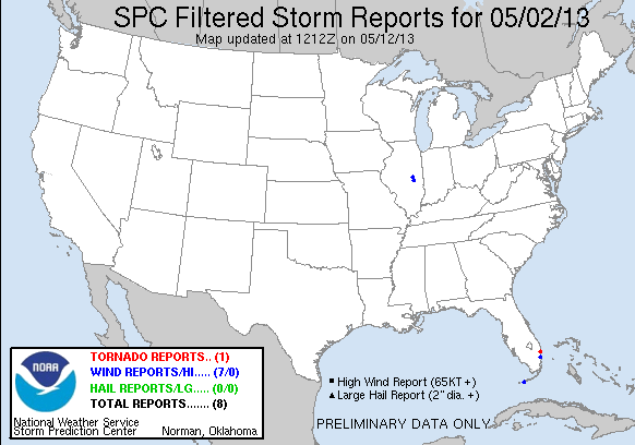
| Filtered Tornado Reports (CSV) (Raw Tornado CSV)(?) |
|---|
Time | | Location | County | State | Lat | Lon | Comments |
| 1725 | | 2 NE BOCA RATON | PALM BEACH | FL | 2638 | 8008 | SURVEY INDICATED AN EF0 TORNADO IN NORTHEASTERN SECTIONS OF BOCA RATON FROM NEAR NORTH DIXIE HIGHWAY AND NE 28 ST TO NEAR FEDERAL HIGHWAY AND NE 32 ST. MAX WINDS ESTIMA (MFL) |
| Filtered Hail Reports (CSV) (Raw Hail CSV)(?) |
|---|
| No reports received |
| Filtered Wind Reports (CSV) (Raw Wind CSV)(?) |
|---|
Time | Speed | Location | County | State | Lat | Lon | Comments |
| 1637 | 58 | KEY WEST | LOWER KEYS IN MON | FL | 2456 | 8178 | WEATHERFLOW STATION AT KEY WEST US COAST GUARD REPORTED A WIND GUST OF 43 KTS. (KEY) |
| 1725 | UNK | 1 NE BOCA RATON | PALM BEACH | FL | 2638 | 8008 | POWER LINES REPORTED DOWN IN THE 2800 BLOCK OF N DIXIE HIGHWAY ... REPORT OBTAINED FROM BOCA RATON LAW ENFORCEMENT VIA SOCIAL MEDIA. (MFL) |
| 1750 | 58 | KEY WEST | LOWER KEYS IN MON | FL | 2456 | 8178 | CAPTAIN JORDAN REPORTED A WIND GUST OF 50 KTS FOR THE SALT POND AREA. (KEY) |
| 1805 | UNK | 1 SW ARTHUR | MOULTRIE | IL | 3971 | 8848 | FOUR POWER POLES BLOWN DOWN ALONG ILLINOIS ROUTE 133 NEAR ARTHUR IN MOULTRIE COUNTY. PEOPLE TRAPPED IN CARS BY DOWNED POWER LINES. NO INJURIES. (ILX) |
| 1805 | UNK | ARTHUR | DOUGLAS | IL | 3972 | 8847 | POWER POLES BLOWN DOWN ALONG ILLINOIS ROUTE 133 NEAR ARTHUR. (ILX) |
| 1913 | 58 | 3 NE BEMENT | PIATT | IL | 3995 | 8853 | ALSO REPORTED INTENSE LIGHTNING AND PEA SIZED HAIL (ILX) |
| 2013 | UNK | DANIA BEACH | BROWARD | FL | 2606 | 8014 | POWERLINES DOWN. (MFL) |
| Full report in comma-separated values (CSV) format and in KML format. |
| Full filtered report in comma-separated values (CSV) format and in KML format. |
| KML files are created with time-enabled placemarks compatible with Google Earth Time Slider. |
| Raw full report in comma-separated values (CSV) format |
| Fields marked UNK are unknown |
| All Times UTC |
| Wind Gusts in MPH |
| Hail Sizes in 1/100 of an Inch (175 = 1.75") |
| LAT/LON in decimal degrees to two decimals, see SPC FAQ for more info |
| List of Weather Forecast Office 3-letter IDs appear in the report comments section |
|
|
|
Top/Storm Reports/Home
|
|
|


 @NWSSPC