|
20120914's Storm Reports (1200 UTC - 1159 UTC) (Print Version)
|
< 120913 Reports
120915 Reports >
|
| Note: All Reports Are Considered Preliminary |
|
|
|
|
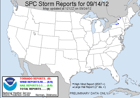
| Tornado Reports (CSV) (Raw Tornado CSV)(?) |
|---|
| No reports received |
| Hail Reports (CSV) (Raw Hail CSV)(?) |
|---|
| No reports received |
| Wind Reports (CSV) (Raw Wind CSV)(?) |
|---|
Time | Speed | Location | County | State | Lat | Lon | Comments |
| 2153 | UNK | 1 SE BUTLER CENTER | WAYNE | NY | 4316 | 7676 | MULTIPLE REPORTS OF TREES DOWN. (BUF) |
| 2212 | UNK | RUSSELL | ST. LAWRENCE | NY | 4443 | 7515 | TREES AND WIRES DOWN ON COUNTY ROAD 17 (BTV) |
| 2233 | UNK | 2 NNE PYRITES | ST. LAWRENCE | NY | 4454 | 7517 | TREES AND WIRES DOWN ON COUNTY ROAD 21 (BTV) |
| 2234 | UNK | WEST PIERREPONT | ST. LAWRENCE | NY | 4449 | 7505 | TREES DOWN ON SELLECK ROAD (BTV) |
| 2240 | UNK | CICERO | ONONDAGA | NY | 4318 | 7612 | POWER LINES DOWN. SPOTTER ESTIMATED WIND GUST OF 50 MPH. (BGM) |
| 2300 | UNK | VIENNA | ONEIDA | NY | 4323 | 7572 | REPORT OF TREE DOWN. ALSO REPORTS OF SCATTERED TREES DOWN ACROSS CENTRAL PARTS OF THE COUNTY BETWEEN 7 AND 8 PM. WINDS ESTIMATED AT 40 TO 50 MPH. (BGM) |
| 2330 | UNK | 1 NNW WHIPPLEVILLE | FRANKLIN | NY | 4482 | 7427 | TREES DOWN ON COUNTY ROUTE 25 FROM MALONE TO WHIPPLEVILLE (BTV) |
| 2332 | UNK | MALONE | FRANKLIN | NY | 4485 | 7429 | TREES DOWN IN TOWN (BTV) |
|

| Filtered Tornado Reports (CSV) (Raw Tornado CSV)(?) |
|---|
| No reports received |
| Filtered Hail Reports (CSV) (Raw Hail CSV)(?) |
|---|
| No reports received |
| Filtered Wind Reports (CSV) (Raw Wind CSV)(?) |
|---|
Time | Speed | Location | County | State | Lat | Lon | Comments |
| 2153 | UNK | 1 SE BUTLER CENTER | WAYNE | NY | 4316 | 7676 | MULTIPLE REPORTS OF TREES DOWN. (BUF) |
| 2212 | UNK | RUSSELL | ST. LAWRENCE | NY | 4443 | 7515 | TREES AND WIRES DOWN ON COUNTY ROAD 17 (BTV) |
| 2233 | UNK | 2 NNE PYRITES | ST. LAWRENCE | NY | 4454 | 7517 | TREES AND WIRES DOWN ON COUNTY ROAD 21 (BTV) |
| 2240 | UNK | CICERO | ONONDAGA | NY | 4318 | 7612 | POWER LINES DOWN. SPOTTER ESTIMATED WIND GUST OF 50 MPH. (BGM) |
| 2300 | UNK | VIENNA | ONEIDA | NY | 4323 | 7572 | REPORT OF TREE DOWN. ALSO REPORTS OF SCATTERED TREES DOWN ACROSS CENTRAL PARTS OF THE COUNTY BETWEEN 7 AND 8 PM. WINDS ESTIMATED AT 40 TO 50 MPH. (BGM) |
| 2332 | UNK | MALONE | FRANKLIN | NY | 4485 | 7429 | TREES DOWN IN TOWN (BTV) |
| Full report in comma-separated values (CSV) format and in KML format. |
| Full filtered report in comma-separated values (CSV) format and in KML format. |
| KML files are created with time-enabled placemarks compatible with Google Earth Time Slider. |
| Raw full report in comma-separated values (CSV) format |
| Fields marked UNK are unknown |
| All Times UTC |
| Wind Gusts in MPH |
| Hail Sizes in 1/100 of an Inch (175 = 1.75") |
| LAT/LON in decimal degrees to two decimals, see SPC FAQ for more info |
| List of Weather Forecast Office 3-letter IDs appear in the report comments section |
|
|
|
Top/Storm Reports/Home
|
|
|


 @NWSSPC