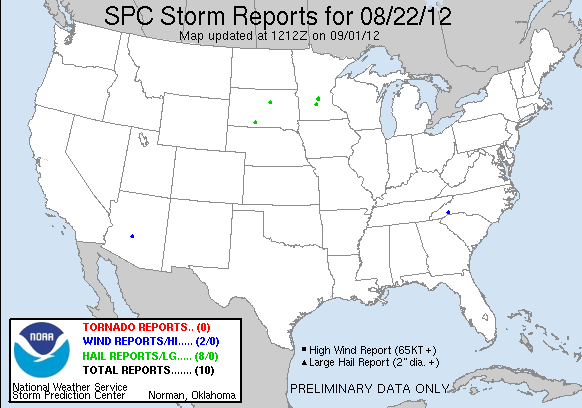
20120822's Storm Reports (1200 UTC - 1159 UTC)
|
< 120821 Reports
120823 Reports >
|
| Tornado Reports (CSV) (Raw Tornado CSV)(?) |
|---|
| No reports received |
| Hail Reports (CSV) (Raw Hail CSV)(?) |
|---|
Time | Size | Location | County | State | Lat | Lon | Comments |
| 1700 | 100 | W STEWART | MCLEOD | MN | 4472 | 9449 | (MPX) |
| 1700 | 100 | STEWART | MCLEOD | MN | 4473 | 9449 | (MPX) |
| 1815 | 100 | 2 S KINGSTON | MEEKER | MN | 4517 | 9431 | (MPX) |
| 1822 | 125 | 4 N DASSEL | MEEKER | MN | 4514 | 9431 | (MPX) |
| 1825 | 100 | 5 NNW COKATO | WRIGHT | MN | 4514 | 9424 | (MPX) |
| 2311 | 100 | PARMELEE | TODD | SD | 4332 | 10102 | (UNR) |
| 2311 | 100 | W PARMELEE | TODD | SD | 4332 | 10103 | (UNR) |
| 0245 | 100 | 9 S SENECA | FAULK | SD | 4493 | 9951 | QUARTER HAIL FROM 935 TO 945 PM. (ABR) |
| Wind Reports (CSV) (Raw Wind CSV)(?) |
|---|
Time | Speed | Location | County | State | Lat | Lon | Comments |
| 0337 | UNK | 1 E DANA | HENDERSON | NC | 3533 | 8236 | A TREE WAS BLOWN ONTO A DOUBLEWIDE MOBILE HOME WITH A MAN INSIDE. THE MAN CAME OUT FROM UNDER THE TREE WITHOUT A SCRATCH. (GSP) |
| 0858 | 60 | 9 E PEORIA | MARICOPA | AZ | 3369 | 11208 | PEAK THUNDERSTORM WIND GUST AT DEER VALLEY AIRPORT (PSR) |
|

| Filtered Tornado Reports (CSV) (Raw Tornado CSV)(?) |
|---|
| No reports received |
| Filtered Hail Reports (CSV) (Raw Hail CSV)(?) |
|---|
Time | Size | Location | County | State | Lat | Lon | Comments |
| 1700 | 100 | STEWART | MCLEOD | MN | 4473 | 9449 | (MPX) |
| 1822 | 125 | 4 N DASSEL | MEEKER | MN | 4514 | 9431 | (MPX) |
| 1825 | 100 | 5 NNW COKATO | WRIGHT | MN | 4514 | 9424 | (MPX) |
| 2311 | 100 | W PARMELEE | TODD | SD | 4332 | 10103 | (UNR) |
| 0245 | 100 | 9 S SENECA | FAULK | SD | 4493 | 9951 | QUARTER HAIL FROM 935 TO 945 PM. (ABR) |
| Filtered Wind Reports (CSV) (Raw Wind CSV)(?) |
|---|
Time | Speed | Location | County | State | Lat | Lon | Comments |
| 0337 | UNK | 1 E DANA | HENDERSON | NC | 3533 | 8236 | A TREE WAS BLOWN ONTO A DOUBLEWIDE MOBILE HOME WITH A MAN INSIDE. THE MAN CAME OUT FROM UNDER THE TREE WITHOUT A SCRATCH. (GSP) |
| 0858 | 60 | 9 E PEORIA | MARICOPA | AZ | 3369 | 11208 | PEAK THUNDERSTORM WIND GUST AT DEER VALLEY AIRPORT (PSR) |
|
| Full report in comma-separated values (CSV) format and in KML format. |
| Full filtered report in comma-separated values (CSV) format and in KML format. |
| Raw full report in comma-separated values (CSV) format |
| Fields marked UNK are unknown |
| All Times UTC |
| Wind Gusts in MPH |
| Hail Sizes in 1/100 of an Inch (175 = 1.75\") |
| LAT/LON in decimal degrees to two decimals, see SPC FAQ for more info |
| List of Weather Forecast Office 3-letter IDs appear in the report comments section |
|
|
|
Top/Storm Reports/Home
|