|
20110826's Storm Reports (1200 UTC - 1159 UTC) (Print Version)
|
< 110825 Reports
110827 Reports >
|
| Note: All Reports Are Considered Preliminary |
|
|
|
|
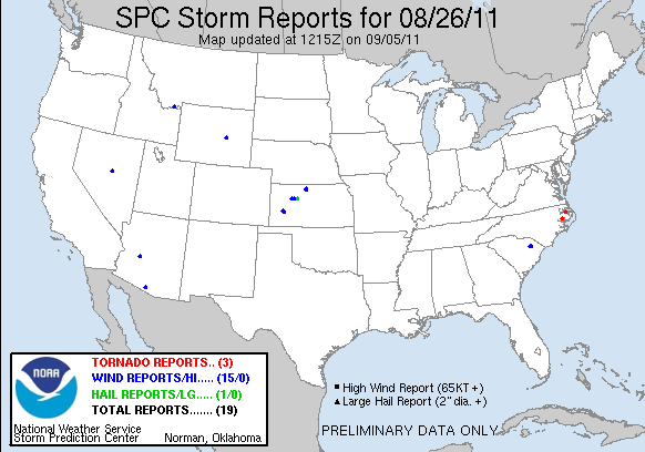
| Tornado Reports (CSV) (Raw Tornado CSV)(?) |
|---|
Time | | Location | County | State | Lat | Lon | Comments |
| 0210 | | BELHAVEN | BEAUFORT | NC | 3554 | 7662 | POSSIBLE TORNADO NEAR BELHAVEN WITH A TRAILER BLOWN OVER (MHX) |
| 0215 | | BELHAVEN | BEAUFORT | NC | 3554 | 7662 | STRUCTURAL DAMAGE TO MULTIPLE TRAILERS ALONG BAY STREET (MHX) |
| 0405 | | COLUMBIA | TYRRELL | NC | 3592 | 7625 | POSSIBLE TORNADO NEAR 1400 BLOCK OF HIGHWAY 64. STRUCTURAL DAMAGE TO AT LEAST 6 HOUSES WITH 2 DESTROYED. MINOR INJURIES REPORTED. (MHX) |
| Hail Reports (CSV) (Raw Hail CSV)(?) |
|---|
Time | Size | Location | County | State | Lat | Lon | Comments |
| 2135 | 100 | 3 WNW ELLIS | TREGO | KS | 3896 | 9961 | (DDC) |
| Wind Reports (CSV) (Raw Wind CSV)(?) |
|---|
Time | Speed | Location | County | State | Lat | Lon | Comments |
| 1945 | UNK | FLORENCE | FLORENCE | SC | 3418 | 7978 | 3 TREES DOWN ON HOUSES IN THE CITY OF FLORENCE (ILM) |
| 1957 | UNK | 3 N EFFINGHAM | FLORENCE | SC | 3411 | 7975 | TREE DOWN ON BANNOCKBURN ROAD NORTH OF EFFINGHAM (ILM) |
| 2155 | 60 | 4 N TREGO CENTER | TREGO | KS | 3894 | 9989 | (DDC) |
| 2205 | 60 | 7 SSW VODA | TREGO | KS | 3895 | 10006 | (DDC) |
| 2234 | 68 | 8 N GARDEN CITY | FINNEY | KS | 3809 | 10086 | (DDC) |
| 2234 | UNK | 8 N GARDEN CITY | FINNEY | KS | 3809 | 10086 | A SEMI OVERTURNED ON HIGHWAY 83 DUE TO THE STRONG THUNDERSTORM WIND GUSTS. (DDC) |
| 2300 | UNK | HARLAN | SMITH | KS | 3961 | 9877 | TREES DOWN NEAR THE CITY OF HARLAN. (GID) |
| 2300 | UNK | GAYLORD | SMITH | KS | 3965 | 9885 | 20 POWER POLES REPORTED DOWN IN THE VICINITY OF GAYLORD CITY LIMITS. POWER OUT IN GAYLORD. (GID) |
| 2305 | 60 | 13 ENE HICKISON SUMMIT | EUREKA | NV | 3950 | 11651 | BEAN FLAT MONITOR NDOT SITE. (LKN) |
| 2310 | 65 | 8 NE GARDEN CITY | FINNEY | KS | 3806 | 10075 | (DDC) |
| 0043 | 60 | 10 NW CASPER | NATRONA | WY | 4293 | 10647 | OUTFLOW WIND (RIW) |
| 0102 | 65 | 6 N LAKEVIEW | BEAVERHEAD | MT | 4468 | 11183 | 65 MPH THUNDERSTORM WIND GUST REPORTED AT RED ROCK RAWS SITE. 0.05 INCHES OF PRECIPITATION ALSO REPORTED WITH OBSERVATION. ELEVATION 6690 FEET MSL. (TFX) |
| 0107 | UNK | 2 NW WICKENBURG | MARICOPA | AZ | 3399 | 11277 | 70 MPH WNDS ESTIMATED BY LAW ENFORCEMENT. POWER POLES DOWNED AND AREA CLOSED TO TRAFFIC (PSR) |
| 0301 | UNK | SELLS | PIMA | AZ | 3192 | 11188 | ROOF DAMAGE ON FOUR HOMES AND ONE POWER POLE DOWN IN THE TOWN OF BIGFIELDS ... ABOUT 10 MILES WEST OF SELLS. TIME OF DAMAGE WAS 230 PM. (TWC) |
| 0311 | UNK | SELLS | PIMA | AZ | 3192 | 11188 | THREE POWER POLES DOWN ... CAUSING WIDE SPREAD POWER OUTAGE. DAMAGE OCCURED AT 250 PM. LOCATION WAS NEAR THE TOWN OF COVERED WELLS ... ABOUT 20 MILES NORTH OF SELLS. (TWC) |
|

| Filtered Tornado Reports (CSV) (Raw Tornado CSV)(?) |
|---|
Time | | Location | County | State | Lat | Lon | Comments |
| 0210 | | BELHAVEN | BEAUFORT | NC | 3554 | 7662 | POSSIBLE TORNADO NEAR BELHAVEN WITH A TRAILER BLOWN OVER (MHX) |
| 0215 | | BELHAVEN | BEAUFORT | NC | 3554 | 7662 | ROOF BLOWN OFF EDGEWATER MOTORS DEALERSHIP (MHX) |
| 0405 | | COLUMBIA | TYRRELL | NC | 3592 | 7625 | POSSIBLE TORNADO NEAR 1400 BLOCK OF HIGHWAY 64. STRUCTURAL DAMAGE TO BUILDINGS WITH INJURIES REPORTED. (MHX) |
| Filtered Hail Reports (CSV) (Raw Hail CSV)(?) |
|---|
Time | Size | Location | County | State | Lat | Lon | Comments |
| 2135 | 100 | 3 WNW ELLIS | TREGO | KS | 3896 | 9961 | (DDC) |
| Filtered Wind Reports (CSV) (Raw Wind CSV)(?) |
|---|
Time | Speed | Location | County | State | Lat | Lon | Comments |
| 1945 | UNK | FLORENCE | FLORENCE | SC | 3418 | 7978 | 3 TREES DOWN ON HOUSES IN THE CITY OF FLORENCE (ILM) |
| 2155 | 60 | 4 N TREGO CENTER | TREGO | KS | 3894 | 9989 | (DDC) |
| 2234 | 68 | 8 N GARDEN CITY | FINNEY | KS | 3809 | 10086 | (DDC) |
| 2234 | UNK | 8 N GARDEN CITY | FINNEY | KS | 3809 | 10086 | A SEMI OVERTURNED ON HIGHWAY 83 DUE TO THE STRONG THUNDERSTORM WIND GUSTS. (DDC) |
| 2300 | UNK | GAYLORD | SMITH | KS | 3965 | 9885 | 20 POWER POLES REPORTED DOWN IN THE VICINITY OF GAYLORD CITY LIMITS. POWER OUT IN GAYLORD. (GID) |
| 2305 | 60 | 13 ENE HICKISON SUMMIT | EUREKA | NV | 3950 | 11651 | BEAN FLAT MONITOR NDOT SITE. (LKN) |
| 2310 | 65 | 8 NE GARDEN CITY | FINNEY | KS | 3806 | 10075 | (DDC) |
| 0043 | 60 | 10 NW CASPER | NATRONA | WY | 4293 | 10647 | OUTFLOW WIND (RIW) |
| 0102 | 65 | 6 N LAKEVIEW | BEAVERHEAD | MT | 4468 | 11183 | 65 MPH THUNDERSTORM WIND GUST REPORTED AT RED ROCK RAWS SITE. 0.05 INCHES OF PRECIPITATION ALSO REPORTED WITH OBSERVATION. ELEVATION 6690 FEET MSL. (TFX) |
| 0107 | UNK | 2 NW WICKENBURG | MARICOPA | AZ | 3399 | 11277 | 70 MPH WNDS ESTIMATED BY LAW ENFORCEMENT. POWER POLES DOWNED AND AREA CLOSED TO TRAFFIC (PSR) |
| 0301 | UNK | SELLS | PIMA | AZ | 3192 | 11188 | ROOF DAMAGE ON FOUR HOMES AND ONE POWER POLE DOWN IN THE TOWN OF BIGFIELDS ... ABOUT 10 MILES WEST OF SELLS. TIME OF DAMAGE WAS 230 PM. (TWC) |
| Full report in comma-separated values (CSV) format and in KML format. |
| Full filtered report in comma-separated values (CSV) format and in KML format. |
| KML files are created with time-enabled placemarks compatible with Google Earth Time Slider. |
| Raw full report in comma-separated values (CSV) format |
| Fields marked UNK are unknown |
| All Times UTC |
| Wind Gusts in MPH |
| Hail Sizes in 1/100 of an Inch (175 = 1.75") |
| LAT/LON in decimal degrees to two decimals, see SPC FAQ for more info |
| List of Weather Forecast Office 3-letter IDs appear in the report comments section |
|
|
|
Top/Storm Reports/Home
|
|
|


 @NWSSPC