|
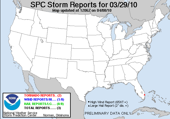
20100329's Storm Report (1200 UTC - 1159 UTC)
|
< 100328 Reports
100330 Reports >
|
|
| Note: All data are considered preliminary |
| Tornado Reports (in CSV format) |
|---|
Time | | Location | County | State | Lat | Lon | Comments |
| 1227 | | 4 W OAKLAND PARK | BROWARD | FL | 2617 | 8020 | TRAINED SPOTTER REPORTED SWIRLING DEBRIS CLOUD MOVED THROUGH I-95 AND OAKLAND PARK BLVD INTERCHANGE, WIND ROCKED CARS. (MFL) |
| 1235 | | OAKLAND PARK | BROWARD | FL | 2617 | 8014 | CHANNEL 4 WEATHER REPORTS TRAILERS TURNED OVER, ROOFS COLLAPSED AND GARAGE DOOR DAMAGE NEAR 40TH ST AND NE 5 TERRACE. (MFL) |
| Hail Reports (in CSV format) |
|---|
| No reports received |
| Wind Reports (in CSV format) |
|---|
Time | Speed | Location | County | State | Lat | Lon | Comments |
| 1236 | 61 | 5 NNE FORT LAUDERDALE | BROWARD | FL | 2619 | 8012 | WIND GUST OF 61 MPH REPORTED BY TRAINED SPOTTER (MFL) |
| Full report
in comma-separated values (CSV) format and in KML format.
| | Fields marked UNK are unknown |
| All Times UTC |
| Wind Gusts in MPH |
| Hail Sizes in 1/100 of an Inch (175 = 1.75") |
| LAT/LON in decimal degrees to two decimals, see SPC FAQ for more info |
| List of Weather Forecast Office 3-letter IDs appear in the report comments section |
|
|
|
Top/Storm Reports/Home
|
|


 @NWSSPC