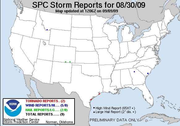
20090830's Storm Report (1200 UTC - 1159 UTC)
|
< 090829 Reports
090831 Reports >
|
|
| Note: All data are considered preliminary |
| Tornado Reports (in CSV format) |
|---|
Time | | Location | County | State | Lat | Lon | Comments |
| 2058 | | 7 SW ROCKPORT | ARANSAS | TX | 2797 | 9713 | PUBLIC REPORTED TORNADO ALONG HIGHWAY 188 (CRP) |
| 0249 | | GALVESTON | GALVESTON | TX | 2930 | 9480 | WATERSPOUT MOVED ONSHORE BETWEEN 37TH AND 25TH STREETS. BLEW WINDOW OUT OF POLICE CAR AND TOOK ROOF OFF A BUILDING. (HGX) |
| Hail Reports (in CSV format) |
|---|
Time | Size | Location | County | State | Lat | Lon | Comments |
| 2026 | 100 | NE STONEWALL | LAS ANIMAS | CO | 3715 | 10502 | MOSTLY PENNY BUT A FEW QUARTER SIZED HAILSTONES. (PUB) |
| 2303 | 88 | 15 W KIM | LAS ANIMAS | CO | 3725 | 10362 | NICKEL SIZED HAIL HAS BEEN FALLING FROM APPROXIMATLY 503 PM TO 518 PM MDT. (PUB) |
| Wind Reports (in CSV format) |
|---|
Time | Speed | Location | County | State | Lat | Lon | Comments |
| 1730 | UNK | LAWRENCEVILLE | GWINNETT | GA | 3396 | 8399 | WSB TV OF ATLANTA REPORTS THAT A TREE FELL ON A HOME ON OAK RIDGE WAY IN LAWRENCEVILLE CAUSING DAMAGE TO THE STRUCTURE. AT LEAST SIX TREES WERE ALSO DOWN IN THE BIRCH L (FFC) |
| 0252 | 58 | MONIDA | BEAVERHEAD | MT | 4456 | 11231 | 58 MPH PEAK WIND GUST AT THE DOT SENSOR NEAR MONIDA (TFX) |
| 0320 | 59 | GALVESTON | GALVESTON | TX | 2930 | 9480 | (HGX) |
| 1105 | UNK | 3 SE LADSON | CHARLESTON | SC | 3295 | 8007 | ONE TREE DOWN ON INTERSTATE 26. (CHS) |
| 1105 | UNK | COLLEGE PARK | BERKELEY | SC | 3302 | 8010 | LOCAL MEDIA REPORTING WINDOWS BLOWN OUT OF CARS AND DORMS AT CHARLESTON SOUTHERN UNIVERSITY. STUDENTS WERE EVACUATED TO TEH LOWEST FLOORS OF THE BUILDING. NATIONAL WEAT (CHS) |
| Full report
in comma-separated values (CSV) format and in KML format.
|
| Fields marked UNK are unknown |
| All Times UTC |
| Wind Gusts in MPH |
| Hail Sizes in 1/100 of an Inch (75 = 0.75") |
| LAT/LON in decimal degrees to two decimals, see SPC FAQ for more info |
| List of Weather Forecast Office 3-letter IDs appear in the report comments section |
|
|
|
Top/Storm Reports/Home
|


 @NWSSPC