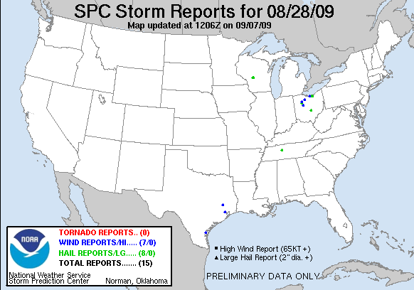
20090828's Storm Report (1200 UTC - 1159 UTC)
|
< 090827 Reports
090829 Reports >
|
|
| Note: All data are considered preliminary |
| Tornado Reports (in CSV format) |
|---|
| No reports received |
| Hail Reports (in CSV format) |
|---|
Time | Size | Location | County | State | Lat | Lon | Comments |
| 1838 | 88 | 2 E THURSTON | FAIRFIELD | OH | 3984 | 8251 | (ILN) |
| 1908 | 88 | VERMILION | LORAIN | OH | 4141 | 8232 | (CLE) |
| 1921 | 175 | ELYRIA | LORAIN | OH | 4138 | 8211 | NEAR HWY 113 (CLE) |
| 1945 | 100 | EATON ESTATES | LORAIN | OH | 4131 | 8201 | (CLE) |
| 2044 | 100 | DOLA | HARDIN | OH | 4078 | 8369 | (ILN) |
| 2100 | 88 | 2 SE BURNS | DICKSON | TN | 3602 | 8729 | NICKEL SIZE HAIL WAS REPORTED NEAR IRON HILL ROAD AND INTERSTATE 40. (OHX) |
| 2300 | 75 | NW MATHER | JUNEAU | WI | 4415 | 9030 | TWO ROUNDS OF DIME SIZE HAIL AROUND 6 PM (ARX) |
| 2300 | 75 | 3 NW MATHER | JACKSON | WI | 4418 | 9034 | TWO ROUNDS OF DIME SIZE HAIL AROUND 6 PM (ARX) |
| Wind Reports (in CSV format) |
|---|
Time | Speed | Location | County | State | Lat | Lon | Comments |
| 1858 | UNK | 3 W VERMILION | ERIE | OH | 4141 | 8238 | A COUPLE OF TREES DOWN. (CLE) |
| 2040 | UNK | TIFFIN | SENECA | OH | 4112 | 8318 | A FEW LARGE LIMBS DOWN. (CLE) |
| 2105 | UNK | 3 N MOUNT BLANCHARD | HANCOCK | OH | 4094 | 8356 | A FEW BRANCHES DOWN (CLE) |
| 2130 | UNK | 2 N BYHALIA | UNION | OH | 4048 | 8346 | TWO TREES DOWN ON CUNNINGHAM-ARBELA ROAD. (ILN) |
| 2155 | UNK | 10 SSW CORPUS CHRISTI | NUECES | TX | 2764 | 9756 | POWER POLES DOWN ON COUNTY ROAD 43 AND COUNTY ROAD 53 AS WELL AS COUNTY ROAD 43 AND FM 2444. REPORTED BY SHERIFFS OFFICE WHEN INFORMED THEM OF SEVERE THUNDERSTORM WARNI (CRP) |
| 2308 | UNK | 5 E NEW WAVERLY | WALKER | TX | 3054 | 9540 | *** 2 INJ *** TREES DOWN ACROSS SH 150 E NEAR ROGERS ROAD. 2 INJURIES FROM TREE FALLING ON VEHICLE AND TRAPPING OCCUPANTS. (HGX) |
| 0118 | 60 | 2 ENE JACINTO CITY | HARRIS | TX | 2978 | 9521 | 60 MPH WIND GUST AT THE BELTWAY 8 AND INTERSTATE 10 INTERSECTION. (HGX) |
| Full report
in comma-separated values (CSV) format and in KML format.
|
| Fields marked UNK are unknown |
| All Times UTC |
| Wind Gusts in MPH |
| Hail Sizes in 1/100 of an Inch (75 = 0.75") |
| LAT/LON in decimal degrees to two decimals, see SPC FAQ for more info |
| List of Weather Forecast Office 3-letter IDs appear in the report comments section |
|
|
|
Top/Storm Reports/Home
|


 @NWSSPC