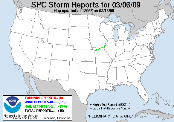
20090306's Storm Report (1200 UTC - 1159 UTC)
|
< 090305 Reports
090307 Reports >
|
|
| Note: All data are considered preliminary |
| Tornado Reports (in CSV format) |
|---|
| No reports received |
| Hail Reports (in CSV format) |
|---|
Time | Size | Location | County | State | Lat | Lon | Comments |
| 0455 | 88 | STEWARTSVILLE | DEKALB | MO | 3975 | 9450 | (EAX) |
| 0514 | 100 | WINSTON | DAVIESS | MO | 3987 | 9414 | REPORT OF SLIGHTLY LARGER THAN QUARTER SIZE HAIL AT THE JUNCTION OF I-35 AND 69. (EAX) |
| 0533 | 100 | GALLATIN | DAVIESS | MO | 3991 | 9396 | 1 INCH HAIL REPORTED AT WEST ENTRANCE TO GALLATIN ON HWY 6. (EAX) |
| 0553 | 75 | 2 S TRENTON | GRUNDY | MO | 4005 | 9360 | RANGE OF PEA TO PENNY SIZE HAIL REPORTED. (EAX) |
| 0630 | 100 | MILAN | SUMNER | KS | 3726 | 9767 | DIME TO QUARTER SIZE HAIL (EAX) |
| 0630 | 100 | MILAN | SULLIVAN | MO | 4020 | 9312 | DIME TO QUARTER SIZE HAIL (EAX) |
| 0645 | 125 | GREEN CASTLE | SULLIVAN | MO | 4026 | 9288 | RANGE OF QUARTER TO HALF DOLLAR SIZE HAIL REPORTED, AS WELL AS SMALLER HAIL THE SIZE OF PENNIES. (EAX) |
| 0732 | 75 | MEMPHIS | SCOTLAND | MO | 4046 | 9217 | DIME TO PENNY SIZE HAIL. HAIL WAS COVERING THE GROUND. (DVN) |
| 0732 | 75 | 5 NE GRANGER | CLARK | MO | 4053 | 9192 | DIME TO PENNY SIZE HAIL COVERING THE GROUND (DVN) |
| 0749 | 75 | 5 NE GRANGER | CLARK | MO | 4053 | 9192 | DIME TO PENNY SIZE HAIL COVERING THE GROUND (DVN) |
| 0749 | 75 | DENMARK | LEE | IA | 4075 | 9133 | (DVN) |
| 0828 | 75 | DENMARK | LEE | IA | 4075 | 9133 | (DVN) |
| 0837 | 125 | BURLINGTON | DES MOINES | IA | 4081 | 9112 | REPORTED IN SOUTH SIDE OF BURLINGTON. (DVN) |
| 0855 | 75 | BIGGSVILLE | HENDERSON | IL | 4085 | 9086 | (DVN) |
| 0900 | 75 | 10 NNE MOUNT GILEAD | MORROW | OH | 4068 | 8276 | (CLE) |
| Wind Reports (in CSV format) |
|---|
| No reports received |
| Full report
in comma-separated values (CSV) format and in KML format.
|
| Fields marked UNK are unknown |
| All Times UTC |
| Wind Gusts in MPH |
| Hail Sizes in 1/100 of an Inch (75 = 0.75") |
| LAT/LON in decimal degrees to two decimals, see SPC FAQ for more info |
| List of Weather Forecast Office 3-letter IDs appear in the report comments section |
|
|
|
Top/Storm Reports/Home
|


 @NWSSPC