|
20090217's Storm Report (1200 UTC - 1159 UTC)
|
< 090216 Reports
090218 Reports >
|
|
| Note: All data are considered preliminary |
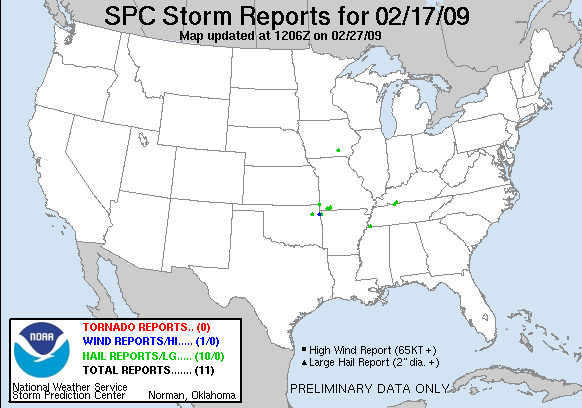
| Tornado Reports (in CSV format) |
|---|
| No reports received |
| Hail Reports (in CSV format) |
|---|
Time | Size | Location | County | State | Lat | Lon | Comments |
| 0330 | 88 | 4 SSE PRYOR | MAYES | OK | 3625 | 9529 | NICKEL SIZED HAIL COVERING THE GOLF COURSE SOUTHEAST OF PRYOR. (TSA) |
| 0346 | 88 | 1 S CASSVILLE | BARRY | MO | 3666 | 9387 | (SGF) |
| 0400 | 88 | 3 W CAPE FAIR | STONE | MO | 3673 | 9356 | (SGF) |
| 0405 | 175 | 1 N SHELL KNOB | BARRY | MO | 3665 | 9363 | (SGF) |
| 0405 | 88 | 4 S GALENA | CHEROKEE | KS | 3702 | 9464 | (SGF) |
| 0415 | 88 | FAIRMOUNT | BENTON | AR | 3623 | 9445 | (TSA) |
| 0433 | 100 | 4 SW GERMANTOWN | SHELBY | TN | 3505 | 8984 | HAIL TO 1 INCH AT INTERSTATE 240 AND GETWELL...LAMAR EXITS (MEG) |
| 0545 | 88 | 5 NNW OTTUMWA | WAPELLO | IA | 4109 | 9246 | HAIL COVERED THE GROUND. SOME HAIL REMAINS ON THE GROUND THIS AFTERNOON. (DMX) |
| 0637 | 75 | CLARKSVILLE | MONTGOMERY | TN | 3656 | 8735 | FT. CAMPBELL BLVD. (OHX) |
| 0645 | 88 | GUTHRIE | TODD | KY | 3666 | 8717 | REPORT RELAYED FROM THE NATIONAL WEATHER SERVICE OFFICE IN NASHVILLE TENNESSEE. (PAH) |
| Wind Reports (in CSV format) |
|---|
Time | Speed | Location | County | State | Lat | Lon | Comments |
| 0358 | 65 | COLCORD | DELAWARE | OK | 3626 | 9469 | (TSA) |
| Full report
in comma-separated values (CSV) format and in KML format.
| | Fields marked UNK are unknown |
| All Times UTC |
| Wind Gusts in MPH |
| Hail Sizes in 1/100 of an Inch (75 = 0.75") |
| LAT/LON in decimal degrees to two decimals, see SPC FAQ for more info |
| List of Weather Forecast Office 3-letter IDs appear in the report comments section |
|
|
|
Top/Storm Reports/Home
|
|


 @NWSSPC