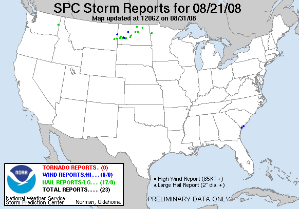
20080821's Storm Report (1200 UTC - 1159 UTC)
|
< 080820 Reports
080822 Reports >
|
|
| Note: All data are considered preliminary |
| Tornado Reports (in CSV format) |
|---|
| No reports received |
| Hail Reports (in CSV format) |
|---|
Time | Size | Location | County | State | Lat | Lon | Comments |
| 1855 | 100 | DISHMAN | SPOKANE | WA | 4766 | 11728 | (OTX) |
| 0125 | 88 | ROLETTE | ROLETTE | ND | 4866 | 9984 | 30 MINUTES OF NICKEL HAIL. (BIS) |
| 0129 | 88 | ANAMOOSE | MCHENRY | ND | 4788 | 10024 | (BIS) |
| 0150 | 88 | 3 W SOUTH FAIRFIELD | BILLINGS | ND | 4712 | 10326 | ESTIMATED 55 TO 60 MPH WINDS (BIS) |
| 0205 | 125 | 5 N DICKINSON | STARK | ND | 4695 | 10279 | (BIS) |
| 0208 | 175 | 19 ESE FALLON | PRAIRIE | MT | 4673 | 10475 | GROUND NEARLY COVERED IN HAIL UP TO GOLF BALL SIZE. (GGW) |
| 0235 | 100 | 15 S WIBAUX | WIBAUX | MT | 4677 | 10419 | HAIL RANGED FROM PEA TO QUARTER SIZE. (GGW) |
| 0235 | 75 | 6 W MADDOCK | BENSON | ND | 4796 | 9966 | (FGF) |
| 0250 | 88 | 7 SW MADDOCK | BENSON | ND | 4789 | 9964 | THE HAIL FELL FOR TEN MINUTES FROM 940 PM TO 950 PM. (FGF) |
| 0300 | 100 | 8 NE RICHARDTON | STARK | ND | 4697 | 10219 | (BIS) |
| 0320 | 75 | MEDORA | BILLINGS | ND | 4691 | 10352 | (BIS) |
| 0330 | 88 | CENTER | OLIVER | ND | 4712 | 10130 | (BIS) |
| 0355 | 88 | 5 N WASHBURN | MCLEAN | ND | 4736 | 10103 | SOME NICKEL SIZE HAIL ACCOMPANIED BY VERY HEAVY RAIN. (BIS) |
| 0400 | 75 | 2 SE HAMPDEN | RAMSEY | ND | 4852 | 9862 | THE HAIL FELL FROM 1100 TO 1105 PM CDT. THE HAIL WAS MOSTLY PEA SIZE. (FGF) |
| 0412 | 88 | 8 NE DICKINSON | STARK | ND | 4696 | 10267 | LASTED 30 MINUTES. (BIS) |
| 0640 | 75 | RICHARDTON | STARK | ND | 4688 | 10232 | (BIS) |
| 0905 | 88 | 2 E CROOKSTON | POLK | MN | 4777 | 9656 | (FGF) |
| Wind Reports (in CSV format) |
|---|
Time | Speed | Location | County | State | Lat | Lon | Comments |
| 2250 | 60 | 11 E SAVAGE | RICHLAND | MT | 4745 | 10411 | PEA SIZE HAIL WITH HEAVY RAIN. (GGW) |
| 2330 | 60 | 4 S MAKOTI | WARD | ND | 4790 | 10180 | WINDS OF 50 TO 60 MPH ALONG WITH PEA SIZE HAIL. (BIS) |
| 0204 | 60 | 6 N DICKINSON | STARK | ND | 4697 | 10279 | (BIS) |
| 0224 | 58 | 7 NW TAYLOR | STARK | ND | 4697 | 10253 | (BIS) |
| 0515 | UNK | BLUFFTON | BEAUFORT | SC | 3224 | 8086 | TREES BLOWN DOWN ONTO A HOUSE IN THE SHADYGROVE SUBDIVISION. (CHS) |
| 0530 | UNK | HUNTING ISLAND | BEAUFORT | SC | 3237 | 8044 | HIGH WINDS DAMAGED A LARGE NUMBER OF TENTS AT HUNTING ISLAND STATE PARK. NO INJURIES REPORTED SO FAR. (CHS) |
| Full report
in comma-separated values (CSV) format and in KML format.
|
| Fields marked UNK are unknown |
| All Times UTC |
| Wind Gusts in MPH |
| Hail Sizes in 1/100 of an Inch (75 = 0.75") |
| LAT/LON in decimal degrees to two decimals, see SPC FAQ for more info |
| List of Weather Forecast Office 3-letter IDs appear in the report comments section |
|
|
|
Top/Storm Reports/Home
|


 @NWSSPC