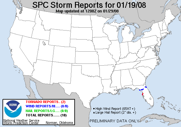
20080119's Storm Reports
|
< 080118 Reports
080120 Reports >
|
|
| Note: All data are considered preliminary |
| Tornado Reports (in CSV format) |
|---|
Time | | Location | County | State | Lat | Lon | Comments |
| 2226 | | NEW PORT RICHEY | PASCO | FL | 2825 | 8272 | TORNADO MOVED THROUGH QUICKLY...MINOR DAMAGE TO AREA TREES...DEBRIS BLOWING ALL THROUGHOUT THE AREA. (TBW) |
| 2245 | | WEEKI WACHEE | HERNANDO | FL | 2852 | 8258 | REPORT FROM PUBLIC OF TORNADO ON GROUND. DAMAGE UNKNOWN. (TBW) |
| Hail Reports (in CSV format) |
|---|
| No reports received |
| Wind Reports (in CSV format) |
|---|
Time | Speed | Location | County | State | Lat | Lon | Comments |
| 2040 | UNK | HORSESHOE BEACH | DIXIE | FL | 2944 | 8329 | NUMEROUS TREES DOWN AROUND HORSESHOE BEACH AND PORTIONS OF SOUTHERN DIXIE COUNTY. A FEW POWER POLES WERE REPORTED SNAPPED. NO STRUCTURAL DAMAGE REPORTED AT THIS TIME. (TAE) |
| 2100 | UNK | BRONSON | LEVY | FL | 2945 | 8264 | TREES DOWN ON HOUSE IN BRONSON. (TBW) |
| 2100 | UNK | CHIEFLAND | LEVY | FL | 2948 | 8286 | TREES AND POWERLINES DOWN...TREE ON HOUSE...BROKEN WINDOWS. (TBW) |
| 2145 | UNK | 10 S GAINESVILLE | ALACHUA | FL | 2953 | 8234 | THERE HAVE BEEN NUMEROUS AND WIDESPREAD REPORTS OF POWERLINES AND TREES DOWN ACROSS THE SOUTHERN PORTION OF THE COUNTY. SEVERAL REPORTS OF BUILDING FIRES HAVE ALSO BEEN (JAX) |
| 2230 | 60 | ST. AUGUSTINE | ST. JOHNS | FL | 2989 | 8131 | AT THE LIGHTHOUSE (JAX) |
| 2230 | UNK | 6 ESE GREEN COVE SPRING | ST. JOHNS | FL | 2996 | 8159 | 2 TREES WERE BLOWN DOWN. (JAX) |
| 2235 | 73 | PORT RICHEY | PASCO | FL | 2828 | 8273 | 61 MPH WIND WITH GUST TO 73 MPH (TBW) |
| 2236 | UNK | PORT RICHEY | PASCO | FL | 2828 | 8273 | DAMAGE ALONG U.S. 19 FROM RIDGE ROAD TO MAIN. TREES DOWN, SIGNS DOWN, TREES DOWN. POWER OUT. (TBW) |
| Full report
in comma-separated values (CSV) format |
| Fields marked UNK are unknown |
| All Times UTC |
| Wind Gusts in MPH |
| Hail Sizes in 1/100 of an Inch (75 = 0.75") |
| List of Weather Forecast Office 3-letter IDs appear in the report comments section |
|
|
|
Top/Storm Reports/Home
|


 @NWSSPC