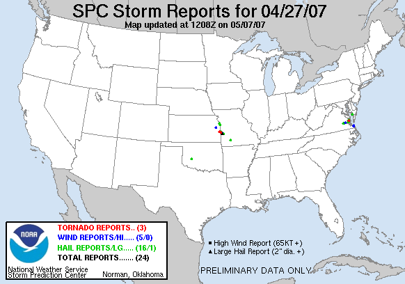
20070427's Storm Reports
|
< 070426 Reports
070428 Reports >
|
|
| Note: All data are considered preliminary |
| Tornado Reports (in CSV format) |
|---|
Time | | Location | County | State | Lat | Lon | Comments |
| 1630 | | ARK | GLOUCESTER | VA | 3744 | 7658 | TIME APPROXIMATE. DAMAGE DETERMINED TO BE ASSOCIATED WITH EF0 TORNADO. DAMAGE BEGAN NEAR STARVATION ROAD AND ENDED NEAR WILLIS ROAD NEAR PETSWORTH ELEMENTARY SCHOOL. MU (AKQ) |
| 2302 | | 1 SE MOUND CITY KS | LINN | KS | 3813 | 9481 | TORNADO ON THE GROUND NEAR SUGAR VALLEY LAKE (EAX) |
| 2320 | | 1 S HUME | BATES | MO | 3808 | 9458 | SPOTTER REPORTED A TORNADO WHICH HAD A CONDENSATION FUNNEL EXTENDING MOST OF THE WAY TO THE GROUND WITH AN ASSOCIATED DUST WHIRL. ALSO 4-5 INCH DIAMETER BRANCHES BROKEN (EAX) |
| Hail Reports (in CSV format) |
|---|
Time | Size | Location | County | State | Lat | Lon | Comments |
| 1525 | 88 | COLONIAL HEIGHTS | CITY OF COLONIAL | VA | 3726 | 7740 | (AKQ) |
| 1535 | 75 | 3 E COLONIAL HEIGHTS | PRINCE GEORGE | VA | 3726 | 7734 | (AKQ) |
| 1538 | 88 | HOPEWELL | CITY OF HOPEWELL | VA | 3729 | 7730 | NICKEL HAIL AT FORT LEE (AKQ) |
| 1538 | 88 | HOPEWELL | HOPEWELL | VA | 3801 | 7582 | NICKEL HAIL AT FORT LEE (AKQ) |
| 1748 | 75 | 6 S COWDEN | WASHITA | OK | 3516 | 9872 | (OUN) |
| 2200 | 75 | SHAWNEE | JOHNSON | KS | 3902 | 9480 | (EAX) |
| 2232 | 88 | OVERLAND PARK | JOHNSON | KS | 3891 | 9468 | ALSO ESTD 55 MPH WINDS (EAX) |
| 2250 | 100 | MOUND CITY KS | LINN | KS | 3814 | 9482 | DIME TO QUARTER SIZE HAIL (EAX) |
| 2305 | 75 | HARCUM | GLOUCESTER | VA | 3752 | 7650 | (AKQ) |
| 2310 | 175 | 2 S HORTON | VERNON | MO | 3795 | 9436 | (SGF) |
| 2315 | 175 | HUME | BATES | MO | 3809 | 9458 | HAIL 3 INCHES DEEP. (EAX) |
| 2325 | 75 | CAMP PEARY | YORK | VA | 3732 | 7666 | (AKQ) |
| 2330 | 275 | METZ | VERNON | MO | 3800 | 9444 | (SGF) |
| 2340 | 100 | WHITE MARSH | GLOUCESTER | VA | 3734 | 7652 | NICKLE TO QUARTER SIZE HAIL (AKQ) |
| 0005 | 100 | WALKER | VERNON | MO | 3790 | 9423 | (SGF) |
| 0150 | 75 | 2 S SPRINGFIELD | GREENE | MO | 3717 | 9329 | (SGF) |
| Wind Reports (in CSV format) |
|---|
Time | Speed | Location | County | State | Lat | Lon | Comments |
| 1547 | UNK | CHARLES CITY | CHARLES CITY | VA | 3734 | 7707 | MULTIPLE TREES DOWN ALONG ROUTE 5 IN CHARLES CITY. (AKQ) |
| 1945 | UNK | PRINCESS ANNE | CITY OF VIRGINIA | VA | 3675 | 7605 | BLEACHERS AT HIGH SCHOOL BASEBALL PARK BLOWN DOWN. (AKQ) |
| 1956 | 59 | OCEANA NAS | CITY OF VIRGINIA | VA | 3682 | 7603 | (AKQ) |
| 2230 | UNK | 1 SSW OTTAWA | FRANKLIN | KS | 3860 | 9527 | DAMAGE REPORTED IN SOUTHWESTERN PORTION OF OTTAWA. QUARTER OF ROOF TORN OFF OF STEEL BUILDING AT INTERSECTION OF EISENHOWER AND I-35. (TOP) |
| 2330 | UNK | METZ | VERNON | MO | 3800 | 9444 | FOUR INCH DIAMETER TREE LIMBS DOWN (SGF) |
| Full report
in comma-separated values (CSV) format |
| Fields marked UNK are unknown |
| All Times UTC |
| Wind Gusts in MPH |
| Hail Sizes in 1/100 of an Inch (75 = 0.75") |
| List of Weather Forecast Office 3-letter IDs appear in the report comments section |
|
|
|
Top/Storm Reports/Home
|


 @NWSSPC