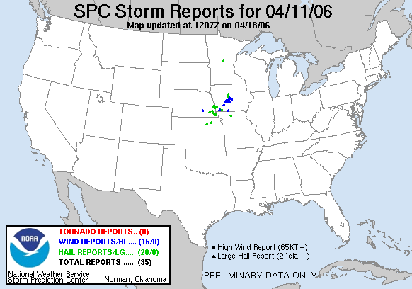
20060411's Storm Reports
|
< 060410 Reports
060412 Reports >
|
|
| Note: All data are considered preliminary |
| Tornado Reports (in CSV format) |
|---|
| No reports received |
| Hail Reports (in CSV format) |
|---|
Time | Size | Location | County | State | Lat | Lon | Comments |
| 1830 | 75 | 5 NE RANDALL | MORRISON | MN | 4614 | 9443 | (MPX) |
| 2315 | 75 | FIRTH | LANCASTER | NE | 4053 | 9660 | (OAX) |
| 2329 | 100 | 1 SW PLATTSMOUTH | CASS | NE | 4100 | 9590 | (OAX) |
| 2330 | 88 | SYRACUSE | OTOE | NE | 4066 | 9618 | (OAX) |
| 2340 | 88 | 5 NW WAKEFIELD | CLAY | KS | 3926 | 9707 | (TOP) |
| 2340 | 75 | GLENWOOD | MILLS | IA | 4105 | 9574 | (OAX) |
| 0003 | 88 | PAPILLION | SARPY | NE | 4116 | 9604 | (OAX) |
| 0007 | 75 | 3 S TREYNOR | POTTAWATTAMIE | IA | 4119 | 9561 | (OAX) |
| 0010 | 75 | JOHNSON | NEMAHA | NE | 4041 | 9600 | (OAX) |
| 0015 | 75 | OMAHA | DOUGLAS | NE | 4126 | 9601 | AT OMAHA-EPPLEY. (OAX) |
| 0020 | 100 | 4 E GLENWOOD | MILLS | IA | 4105 | 9567 | (OAX) |
| 0028 | 75 | WESTMORELAND | POTTAWATOMIE | KS | 3940 | 9642 | (TOP) |
| 0045 | 88 | STELLA | RICHARDSON | NE | 4023 | 9577 | (OAX) |
| 0045 | 75 | 5 SSW NEMAHA | NEMAHA | NE | 4027 | 9571 | (OAX) |
| 0057 | 88 | CLARINDA | PAGE | IA | 4074 | 9504 | (OAX) |
| 0110 | 88 | 1 N NEW MARKET | TAYLOR | IA | 4073 | 9488 | WIND GUSTS OF 40 TO 50 MPH. (DMX) |
| 0211 | 75 | 4 NW DES MOINES | POLK | IA | 4163 | 9367 | DELAYED REPORT. (DMX) |
| 0213 | 100 | 5 N BOONE | BOONE | IA | 4212 | 9388 | (DMX) |
| 0235 | 75 | 5 S WEBSTER CITY | HAMILTON | IA | 4239 | 9382 | (DMX) |
| 0335 | 88 | TRENTON | GRUNDY | MO | 4008 | 9360 | (EAX) |
| Wind Reports (in CSV format) |
|---|
Time | Speed | Location | County | State | Lat | Lon | Comments |
| 0000 | 70 | MCCOOL JUNCTION | YORK | NE | 4074 | 9760 | COOPERATIVE OBSERVER REPORTED WIND GUSTS TO 70 MPH AND MARBLE SIZED HAIL (GID) |
| 0053 | 60 | YORKTOWN | PAGE | IA | 4074 | 9515 | (OAX) |
| 0113 | 60 | FONTANELLE | ADAIR | IA | 4129 | 9456 | (DMX) |
| 0129 | 60 | PANORA | GUTHRIE | IA | 4169 | 9436 | (DMX) |
| 0149 | 60 | 5 NNE ADEL | DALLAS | IA | 4169 | 9400 | (DMX) |
| 0150 | 64 | PERRY | DALLAS | IA | 4184 | 9410 | FROM KCCI-TV (DMX) |
| 0150 | UNK | PERRY | DALLAS | IA | 4184 | 9410 | LARGE TREE LIMBS...10 TO 12 INCH DIAMETER...DOWN AND LARGE SIGN BLOWN OVER. (DMX) |
| 0203 | 60 | MADRID | BOONE | IA | 4188 | 9382 | FROM KCCI TV SCHOOLNET (DMX) |
| 0205 | 63 | WEST DES MOINES | POLK | IA | 4157 | 9375 | 11TH AND ASHWORTH (DMX) |
| 0210 | UNK | WINDSOR HEIGHTS | POLK | IA | 4160 | 9371 | TREE LIMBS DOWN...ABOUT 4 TO 6 INCH IN DIAMETER. (DMX) |
| 0210 | UNK | 3 E MADRID | BOONE | IA | 4188 | 9376 | POLE BARN DOWN REPORTED BY KCCI. (DMX) |
| 0215 | UNK | 1 NW LAMONI | DECATUR | IA | 4063 | 9395 | DELAYED REPORT...NEW GARAGE BLOWN DOWN (DMX) |
| 0216 | 60 | AMES | STORY | IA | 4202 | 9363 | (DMX) |
| 0225 | UNK | URBANDALE | POLK | IA | 4164 | 9374 | CHIMNEY TOPPLED. FROM KCCI TV. (DMX) |
| 0230 | UNK | MAXWELL | STORY | IA | 4189 | 9340 | WINDOW BLOWN OUT OF MOBILE HOME. (DMX) |
| Full report
in comma-separated values (CSV) format |
| Fields marked UNK are unknown |
| All Times UTC |
| Wind Gusts in MPH |
| Hail Sizes in 1/100 of an Inch (75 = 0.75") |
| List of Weather Forecast Office 3-letter IDs appear in the report comments section |
|
|
|
Top/Storm Reports/Home
|


 @NWSSPC