|
20060404's Storm Reports
|
< 060403 Reports
060405 Reports >
|
|
| Note: All data are considered preliminary |
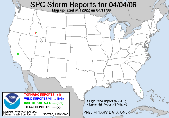
| Tornado Reports (in CSV format) |
|---|
Time | | Location | County | State | Lat | Lon | Comments |
| 0134 | | HAGERMAN | GOODING | ID | 4282 | 11490 | EXTENSIVE DAMAGE IN HAGERMAN AREA. MOST DAMAGE STRAIGHT LINE BUT EVIDENCE POINTS TO WEAK TORNADO EMBEDDED IN THE GUST FRONT. SEVERAL TREES BLOWN INTO AND ONTO HOUSES... (BOI) |
| Hail Reports (in CSV format) |
|---|
Time | Size | Location | County | State | Lat | Lon | Comments |
| 2259 | 75 | DINUBA | TULARE | CA | 3655 | 11939 | (HNX) |
| 2303 | 100 | REEDLEY | FRESNO | CA | 3660 | 11945 | NICKEL TO QUARTER SIZE HAIL. (HNX) |
| 2304 | 75 | GOSHEN | TULARE | CA | 3635 | 11942 | (HNX) |
| 2310 | 175 | BUCKHEAD RIDGE | GLADES | FL | 2714 | 8089 | GOLF BALL SIZE HAIL WAS REPORTED TO THE SHERRIF OFFICE FROM BUCKHEAD RIDGE AROUND 710 PM EST. (MFL) |
| 2326 | 75 | VISALIA | TULARE | CA | 3633 | 11932 | IN SW VISALIA. (HNX) |
| 0145 | 100 | 1 SW GOODING | GOODING | ID | 4293 | 11473 | HAIL ALMOST COVERING THE GROUND (BOI) |
| Wind Reports (in CSV format) |
|---|
| No reports received |
| Full report
in comma-separated values (CSV) format |
| Fields marked UNK are unknown |
| All Times UTC |
| Wind Gusts in MPH |
| Hail Sizes in 1/100 of an Inch (75 = 0.75") |
| List of Weather Forecast Office 3-letter IDs appear in the report comments section |
|
|
|
Top/Storm Reports/Home
|
|


 @NWSSPC