

Fig. 1. Temporal distributions of severe thunderstorm events as a function of intensity.
Norman, OK 73069
January 1999
1. INTRODUCTION
As part of its verification effort, the Storm Prediction Center (SPC) maintains a database of severe thunderstorm events (tornadoes, large hail, and damaging winds) reported over the United States. Tornado information is available back through 1950, while the wind and hail records start in 1955. These data are available for a nominal fee that covers the cost of dissemination. An old version of the database in ZIP format is available on the SPC's homepage (http://www.spc.noaa.gov); this will be replaced with an updated, more user friendly version as time permits.
With these data, it is possible to perform analysis of severe thunderstorms not only on the national scale, but also on a site-specific basis. This paper presents an overview analysis of the database. It illustrates some of the problems that exist in the data. However, it also shows that there is intrinsic value in this information even with its aleatoric and epistemic uncertainties.
2. DATA
In accordance with NWS criteria (NWS, 1995), a severe thunderstorm is defined as
The metric equivalent of these values are 25.8 ms-1 and 19 mm for wind and hail respectively.
Since 1972, there has been a concerted effort to maintain agreement between these data and the entries in the NOAA publication Storm Data. Prior to 1972, tornado data was obtained directly from Storm Data or its predecessor, Climatological Data National Summary - Storm Data and Unusual Phenomena, while the wind and hail data was obtained from real time information collected by the U.S. Air Force.
Although there is a continuing effort to insure complete and accurate data, the possibility of errors does exist. For instance, the wind and hail data for 1972 (the transition year) are known to be incomplete. If possible, the database is updated to correct any errors that are reported to the SPC.
Information available for tornadoes includes occurrence time, observed path length, average track width, latitude/longitude of touchdown and lift-off points, the Fujita scale estimate of storm intensity (Fujita, 1971), and the number of fatalities and injuries attributable to the storm.
Since hail and wind reports typically come from specific observers, no information is available about the size and path of the hail and damage swath. In an effort to account for this, hail and wind data are arbitrarily quantified by requiring that reports of the same type event within any one county be separated by at least 16 km or 15 minutes (Grenier and Halmstead, 1986). The database contains the time, latitude/longitude, intensity (hail size, maximum gust), and the number of fatalities and injuries caused by each event. Since 1996, estimates of the dollar amount of damage are also recorded.
3. NATIONAL OVERVIEW
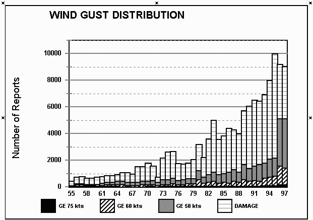
An examination of the national occurrence rate of severe thunderstorms (fig. 1) gives an indication of the quality of the data. Over the years, there has been an increase in the number of reports for each type of event. This reflects overall changes in society, new weather observing technologies, and enhanced communications. The rural population decreased while the urban one increased. The first national weather surveillance radar network was not in place until the late 1950s. Mobile telephones were virtually unknown.
Fig. 1. Temporal distributions of severe thunderstorm events as a function of intensity.
For tornadoes, the long term trend is nearly linear, with an increase of 15 tornadoes per year. However, there are periods of markedly decreased activity in the late 1960s (approximately 1968-1970), the late 1970s (~1976-1982), and the mid-late 1980's (~1986-1989). These are most likely due to the natural year-to-year variations in the synoptic scale flow. The general increase is most likely related to heightened public awareness of the tornado hazard, and improved communications.
Interestingly, a marked decrease in the number of F2 and greater tornadoes occurred in 1978. This is most likely related to the way the intensity of tornadoes was rated. The rating for storms from the 1950's through the early 1970's was obtained almost entirely from reading articles and looking at published photographs. Since devastation sells newspapers, it is likely that there is a high bias in the F-scale ratings during the early years of the database. From the late 1970's on, most of the ratings were made by personnel from the local NWS office, many of whom made surveys of the most significant storms.
The increase in the annual number of large hail and wind reports is much more dramatic than that in the number of tornadoes. The increased emphasis that the NWS started placing on warning verification, starting around 1980, is apparent by a sharp increase in the slope of the trend line. The slope became even steeper with the national implementation of the WSR-88D radars with their Doppler capability, beginning in about 1991. Increased warnings will bring about an increase in the number of reports as the public and the media are made aware to the occurrence of conditions that are conducive to severe thunderstorm activity.
While there has been a slow increase in the annual number of reports for all types of severe weather except the most extreme events (hail greater than 500 mm, wind gusts greater than 38.5 m s-1), "low-end" events (190 to 254 mm hail, and "damaging" winds) account for most of the increase. The effects that procedural changes can have on the data is illustrated by the jump in the number of 28.5 to 30.9 m s-1 wind reports in 1996 and 1997. This change occurred when it became mandatory that a wind report contain either an estimated wind speed or a dollar value for the damage.
Monthly distributions of the number of tornadoes, large hail storms, and damaging wind events were also computed (Fig. 2). May and June are the peak months for the occurrence of tornadoes and large hail. In contrast, July and June are the top months for wind storms. Many of these wind storms occur as derechoes over the Great Lakes states (Johns and Hirt, 1987).


Fig. 2. Monthly distribution of severe thunderstorm events over the United States.
A weak secondary maximum in both tornado and wind storm activity is also seen in November. This is related to the migration of the jet stream southward during the transition from the warm to the cold season. When tornado intensity is considered, the months of maximum activity shift. Violent tornadoes (F4 and F5) are most prevalent in April, while weaker tornadoes are more of a May/June phenomena.
4. REGIONAL ANALYSES
To demonstrate how severe thunderstorm characteristics vary across the country, the data was subdivided into three regions, the South Plains (29o-30oN, 95o-105oW), the North Plains (39o-49oN, 95oN-105oW), and the Southeast (30o-40oN, 80o-90oW). The South Plains area roughly corresponds to what is thought of as "tornado alley," consisting of Texas, Oklahoma, Kansas, and the Prairie east of the Rockies.
The North Plains includes Nebraska, the Dakotas, and Northeast Colorado, and is a region generally considered susceptible to hail storms. The Southeast includes much of the old South including Mississippi, Alabama, Georgia, Tennessee, Kentucky and parts of adjacent states.
A comparison of the hourly distribution of tornadoes is given in Fig. 3. Even though a rigorous comparison would require normalization by "sun time," even this simplified analysis shows that nocturnal tornadoes are much more prevalent in the Southeast than across the Great Plains. The more nocturnal nature of tornadoes over the Southeast would be even more striking if the percent of tornadoes that occur each hour in a region were graphed.


Fig. 3. Diurnal distribution of tornadoes
The nocturnal nature of severe thunderstorms in the Southeast is also very apparent in diurnal distribution of wind reports (Fig. 4). Also, it is interesting to note the high number of wind storms in the Southeast compared to the other two regions. (Note the regions are all 10o latitude/longitude squares, so there is a slight difference in their actual size). One has to wonder if this is based on meteorology of if it is related to higher number of trees in the Southeast as compared to the Great Plains. Tree damage and damage due to falling trees are common severe thunderstorm wind reports.


Fig. 4. Diurnal distribution of severe convective wind
When large hail is considered (fig.5) none of the three regions show any significant nocturnal activity. Insolation plays an important role in initiating hail producing thunderstorms. Also, these data do not support conventional wisdom, in that the North Plains is not the nation's center of hail activity. Over twice the number of large hail storms have been reported over the South Plains as over the North Plains.


Fig. 5. Diurnal distribution of large hail
The monthly distribution of severe weather by region shows the progression of the severe thunderstorm maximum from from the Southeast in the early spring through the South Plains in the late spring and to the Northern Plains in summer (fig. 6). This progression is even more pronounced when only the strongest events are considered. In the Southeast, the peak month for the occurrence of hail greater than 51 mm in diameter is in April while the most favored month for any hail greater than 19 mm is in May. There is a rapid decrease in severe hail reports after the onset of summer. This is especially notable over the South Plains.


Fig. 6. Monthly distribution of large hail
In November, a weak secondary maximum in all sizes of large hail occurs over the Southeast. This maximum is also found in the tornado and damaging wind data from the Southeast (fig. 7). However, as can be seen in fig. 6, there is no trace of it in the hail observations from the other regions. The tornado and wind storm data from the other regions studied (not shown) also do not have a fall maximum. Even though there is a general southward progression of the jet stream and its attendant circulations as the cool season begins, autumn severe thunderstorms do not occur with enough regularly to cause a cool season frequency maximum anywhere but over the Southeast.


Fig. 7. Monthly tornado and severe convective wind distributions over the Southeast
5. CAUTIONS
Even though there are 37,755 torandoes, 97,752 hail events, and 133,687 wind storms in the database, we have to remember that severe thunderstorms are rare events. The data distributions are such that even for areas as large as the regions examined in Section 4, a few major synoptic-scale events can bias the analysis.
For instance on April 3 and 4, 1974, 118 tornadoes occurred in the Southeast region. Of these, 28 were rated as F4 or greater. Because of one storm system, 1974 had more F4 and F5 tornadoes in the Southeast than any other year of record (fig. 8). Further, the April 3-4, 1974 storm did not impact either of the other two regions studied. Since 1974 was a La Nina year, an examination of only the annual distribution could lead one to argue that there is a correlation between strong tornadoes in the Southeast and the ENSO phase.


Fig. 8. Temporal distributions of tornadoes as a function of intensity.
Since each entry in the database has an associated latitude/longitude, these data can be used to perform site-specific analyses. However, because of the inherent biases in the data it behooves the analyst to carefully examine the local area data, and compare its statistics to those from a broader region within which it is embedded. One should carefully examine local inhomogeneities before ascribing meteorological significance to them. Perhaps, local "hot spots" for severe thunderstorms do exist, but the data is such that it is generally impossible to distinguish a difference in the hazard between one side of a town to the other.
Acknowledgements: We would like to express our appreciation to the many people who have helped maintain the SPC database over the years. This includes, but is not limited to, Donald Kelly, David Higginbotham, Laurence Lee, Leo Grenier, John Halmstad, and Paul Polger.
6. REFERENCES
Fujita, T.T., 1971: Proposed Characterization of Tornadoes and Hurricanes by Area and Intensity. Satellite and Meteorology Research Paper, 91, The University of Chicago, Chicago, IL 42 pp.
Grenier, Leo, and J. T. Halmstad, 1986: Severe Local Storm Verification Preliminary Procedures. NOAA Tech. Memo. NWS NSSFC-12, National Weather Service, Silver Spring, MD 20910, 10 pp.
Johns, R.H., and W.D. Hirt, 1987: Derechoes: Widespread Convectively Induced Windstorms. Wea. Forecasting, 2, 32-49.
NWS Operations Manual, Chapter C-40, 1995: National Weather Service, Silver Spring, MD 20910, 61 pp.