
Figure 1. Topography of north central Wyoming. Shaded are elevations above 7500 ft M.S.L.
SIGNIFICANT TORNADOES IN THE BIG HORN MOUNTAINS OF WYOMING
1. INTRODUCTION
Though tornadoes are most commonly associated with thunderstorms developing over the relatively flat regions of the central United States, research has shown that tornadoes can occur in a variety of terrain regimes, including mountainous terrain. (e.g. Fujita 1989, Evans and Johns 1995). Evans and Johns (1995) found that eighteen tornadoes were reported in mountainous regions of Wyoming over the forty-four-year period from 1950-1993 (Storm Data), yielding an average occurrence of about once every other year. Further, such tornado development occurred during the summer months of June, July and August, and was found to be typically associated with southwesterly flow aloft.
It has also become evident over the past several years that significant tornadoes (classified here has F2 or greater events on the Fujita intensity scale) can occur in very rugged mountainous terrain. Of the eighteen mountain tornadoes in the Evans and Johns study, five were rated as strong or violent in intensity (F2 or greater). All five strong or violent tornadoes took place under a southwesterly flow regime and were associated with more pronounced short wave troughs and stronger wind fields than was the case with the weaker intensity (F0-F1) tornado situations.
The Big Horn mountains in the north central part of the state (Fig. 1) experienced the greatest number of tornadoes of any Wyoming range during the forty-four-year period that Evans and Johns examined. Seven tornadoes were reported in this range, three of which were rated as strong (F2 or F3) intensity.
Figure 1. Topography of north central Wyoming. Shaded are elevations above 7500 ft M.S.L.
This study focuses on the synoptic scale conditions associated with the three strong tornadoes which occurred in the Big Horns on three separate days: June 26, 1959, August 2, 1985, and July 21, 1993. (see Table 1.) The tornadoes occurred in the northwestern section of the Big Horn mountains in extreme northeastern Big Horn county. All the tornadoes occurred within a twenty mile diameter area and affected elevations above 8000 ft M.S.L.

Table 1. Known significant tornadoes in the Big Horn mountains of Wyoming during the period of 1950-1993.
The 1959 tornado was two hundred yards wide and stayed on the ground for three miles as it moved north-northeast across Shell Canyon. This tornado resulted in the only known fatality from a mountain tornado in the western United States, and is one of only two tornadoes known to have caused a fatality in Wyoming. The other occurred in Cheyenne in 1979. (see Parker and Hickey 1980.) The 1993 Big Horn tornado was on the ground for almost eight miles and reached a half-mile in width as it moved across Dayton Gulch. Though the 1985 tornado was the smallest of the three events discussed here, it was rated the strongest according to Storm Data and blew down over 600 acres of harvestable timber in roughly the same area as the 1993 tornado.
A possible fourth event occurred during the summer of 1978 or 1979 about seven miles east of the 1959 tornado, according to the Big Horn National Forest Service. This event had a damage path 5 miles long and half a mile wide. Since the exact date of this event is unknown, it was not included in this study.
2. GEOGRAPHY/TERRAIN
The Big Horn mountain range extends along a southeast to northwest orientation across north central Wyoming and extreme southern Montana, and is located about 150 miles east of the Continental Divide. (see Fig. 1.) Elevations vary from 6000 ft M.S.L. to just over 13000 ft M.S.L. Cloud Peak, the highest elevation in the Big Horns at 13175 ft M.S.L., is located near the center of the range, southwest of Sheridan, Wyoming, and is generally regarded as the dividing point between the "northern" and "southern" Big Horns.
The Big Horn mountains are surrounded by some of the lowest terrain in the region as elevations fall under 4000 ft M.S.L. across extreme northeast Wyoming, with elevations under 3000 ft M.S.L. in eastern Montana. The Big Horn basin lies immediately to the west of the Big Horn mountains and separates them from the Absaroka range in northwestern Wyoming. Elevations in the Big Horn basin generally range from 4000 ft to 5000 ft M.S.L. While the Big Horn and Absaroka mountains define the eastern and western borders of the Big Horn basin, the Owl Creek mountains, a small range of mountains with elevations ranging between 7000 ft and 8000 ft M.S.L., lie along the southern periphery of the basin. There is no major geographical barrier to the north of the Big Horn basin.
The proximity of lower terrain and location well east of the continental divide make the Big Horns more likely to experience deeper moisture from the Gulf of Mexico than mountains further to the west and southwest.
3. SYNOPTIC SCALE FEATURES
Evans and Johns found that southwesterly flow at the mid and upper levels of the troposphere was associated with all five of the F2 or greater tornado events in Wyoming, including the three events discussed here (Fig. 2). In each case a strong shortwave trough was located upstream from Wyoming at 1200 UTC on the day of tornado occurrence, which moved eastward into western Wyoming or eastern Idaho during the afternoon.

Figure 2. 500 mb composite for the five F2 or greater mountain tornado events in Wyoming at 1200 UTC on the day of occurrence (After Evans and Johns 1995).
On two of the three days in which a significant tornado occurred in the Big Horns (1959 and 1993), the upper system affecting Wyoming was an open trough. With the other occurrence (1985), the upper system started out as a closed low over eastern Oregon during the morning, which moved eastward as an open trough that afternoon. In all three cases, the location of the trough placed Wyoming under a jet axis at the upper levels of the troposphere with 250 MB wind speeds at or above 25 m/s ( 50 kt). (not shown). A 250 MB speed maximum of greater than 30 m/s (60 kt) was embedded in the jet and moved over southern and central Wyoming during the afternoon, placing the north central part of the state under diffluent flow aloft associated with the left exit region of the jet maximum.
The composite chart at 500 MB for the five significant mountain tornado events in Wyoming, using upper air data from 1200 UTC prior to the event (Fig. 2), shows a well defined and negatively tilted trough extending from the Pacific Northwest into the lower Colorado valley. Since the 500 MB charts for the individual events are similar to one another, this composite is very representative of the flow aloft over Wyoming on the days in which a significant tornado occurred in the Big Horns. In each of the strong Big Horn tornado cases, mid-tropospheric temperatures were rather cold for mid to late summer. Temperatures were between -10 deg C and -12o C at Lander, WY at 1200 UTC in all three cases, while temperatures at or below -15 deg C were present over the northern intermountain region of Idaho and Nevada. Mid troposhperic (500 MB) temperatures cooled on average about 1 to 2 deg C over Lander, WY from 1200 UTC to 0000 UTC on the day of occurrence. This suggests mid level cold air advection played only a minor role in airmass destabilization in these three cases, which is similar to findings by Evenson and Johns (1995) regarding severe thunderstorms in the northwestern U.S.
At the surface, a low developed over west central or central Wyoming in two cases, 1985 and 1993, along an intersection between a north to south oriented cold front and a quasi stationary front or convergence boundary which extended eastward across northern Wyoming. The low then moved east across north central or central Wyoming during the afternoon, and was located very near or to the east of the northern Big Horns near the time of tornado occurrence. (see Figs. 3 and 4). In the 1959 case, the surface low developed over south central Wyoming and tracked northeastward into northeastern Wyoming during the afternoon. (see Fig. 5). On all three days, a cold front extended southward from the low with a cold or occluded front extending northward across central or eastern Montana.

Figure 3. Surface chart near time of occurrence for 1800 UTC 2 August 1985 tornado. "T" denotes location of tornado. Isobars (solid) at intervals of two millibars. Isodrosotherms (dashed) in degrees Fahrenheit.

Figure 4. As in Fig. 3, except with selected surface data plots for 0000 UTC 22 July 1993. Temperatures and dewpoints in degrees Fahrenheit. Full wind barb equals 10 Kt (5 m/s).
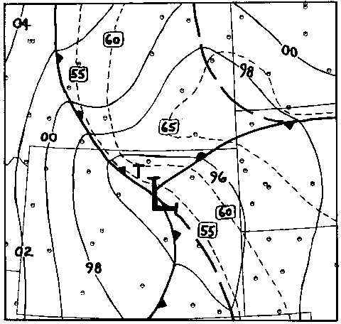
Figure 5. As in Fig. 3, except for 1800 UTC 26 June 1959, just prior to tornado occurrence.
The location and movement of the surface low is significant since this allowed north or northeasterly low level winds to develop on all three days across north central Wyoming and eastern Montana. This enabled low level moisture to advect southwestward out of eastern Montana and into north central Wyoming. As mentioned previously, geographical barriers border the Big Horn basin on all sides but to the north, which makes the most effective direction for advection of low level moisture into the basin to be from the north or northeast out of southeastern Montana.
4. THUNDERSTORM EVOLUTION
Examination of satellite imagery from the 1985 and 1993 events (not shown), and operational experience by the lead author, indicate that initial development of the thunderstorms responsible for the Big Horn tornadoes occurred well west of the Big Horns in these cases, and appeared to have been associated with larger scale forcing associated with the upper level system. Surface observations and satellite data suggest these storms were initially high based, but became lower based and intensified as they encountered higher values of low level moisture in the Big Horn basin. No satellite images were available for the 1959 Shell Canyon tornado, however the surface observations suggest that a convective evolution similar to the other two cases was possible.
5. CASE STUDY
On 21 July 1993, a large tornado developed over the northern Big Horn mountains northeast of Greybull, WY. (See "T" on Fig. 4). The tornado formed near Little Bald Mountain (elevation 9907 ft M.S.L.), just north of Wyoming Highway 14-alternate, and moved north and then northeastward destroying over 1500 acres of harvestable timber before lifting nearly eight miles later. Maximum width of the damage path was approximately one-half mile.
Though this event was initially interpreted as damage from "straight line" thunderstorm winds, detailed analysis of aerial photographs of the damage, taken by the U. S. Forest Service the day after the event, revealed that the event was a tornado. In addition, a man leading a hiking exhibition just south of Highway 14-alternate described seeing "a large, black, rotating funnel cloud" extending downward from the thunderstorm base as it moved out of the Big Horn basin, shortly before it disappeared behind Little Bald Mountain.
The middle and upper tropospheric pattern over the western United States at 1200 UTC on the day of occurrence was very similar to the composite shown in Fig. 2. The 500 MB analysis (Fig. 6), indicated a negatively tilted trough over the Great Basin, which moved eastward to the western Wyoming border during the afternoon. Winds at 500 MB were greater than 30 kt (15 m/s) over the northern intermountain region and the northern Rockies. At 250 MB (not shown), northern Wyoming remained under the left exit region of an upper jet streak with winds at or above 60 kt (30 m/s) across the central part of the state.

Figure 6. 500 mb analysis for 1200 UTC on 21 July 1993.
Surface cyclogenesis occurred over central Wyoming at the intersection of a north-south oriented cold front and a developing warm front during the late afternoon. This low deepened and moved northeastward over north central Wyoming with a 1000 MB low center located just southeast of Sheridan, WY at 0000 UTC (Fig. 4). Increasing south to southeasterly surface winds developed over the High Plains region as a result of pressure falls over the northern Rockies. These winds carried moisture from the Gulf of Mexico northward. The moisture was then advected northwestward, following the lower terrain, across the western Dakotas and into eastern Montana. As low level winds became more northerly over northern Wyoming during the afternoon, this moisture was advected southwestward into north central Wyoming.
A sounding for the Big Horn basin near the time of occurrence was constructed by modifying the 0000 UTC 22 July sounding from Lander, WY. This sounding was modified by SHARP (SkewT-Hodograph Analysis and Research Program) version 95 (Hart 1995) using the surface temperature, dew point, wind direction, and wind speed at Worland, which is in the Big Horn basin. (See Fig. 7). The modified sounding suggests the airmass was strongly unstable with surface based lifted indices of -10 and CAPEs near 3500 j/kg. Northerly surface winds in the Basin strongly veered to southwesterly above the boundary layer, used as approximately 2500m MSL here. This resulted in 0-3 km AGL storm relative helicities of 200 m2/s2 using a storm motion of 235 degrees at 25 kt, which is 30 degrees to the right and 70 percent of the mean wind.

Figure 7. Modified Lander, WY sounding and hodograph for 0000 UTC on July 22, 1993 representing conditions in the Big Horn Basin near time of tornado occurrence. CAPE (convective available potential energy) is shaded.
Though strong to severe thunderstorms did develop along the lee trough/dry line which extended from northeastern Wyoming to eastern Colorado during the late afternoon, the thunderstorm responsible for producing the tornado discussed here developed well west of the low level moisture axis in stronger synoptic scale forcing associated with a shortwave trough. The storm intensified rapidly as deeper low level moisture and increased storm relative inflow were encountered in the Big Horn basin. One-half inch diameter hail was reported from Greybull, WY at approximately 2330 GMT as the storm moved through the area. Shortly after this, the hiker reported seeing the "large funnel cloud" protruding from the storm as it moved into the northern Big Horns and subsequently produced the large tornado. Further east, hail was reported from the storm at Burgess Junction which is just over 10 miles east of the large tornado event. The storm continued to be intense as it moved from the Big Horn mountains into the deeper moisture across southeastern Montana. Several more reports of large hail and damaging winds were received from this storm as it move across sparsely populated eastern Montana through the evening. However, there were no more reports of tornadoes.
6. CONCLUSION
Three strong (F2-F3) tornadoes have been reported within a twenty mile diameter area in the northern Big Horn mountains since 1950. These events occurred during the summer months of June, July or August and were associated with very similar synoptic scale features. All events occurred under southwesterly flow at the middle and upper levels of the troposphere under the left exit region of an upper level jet maximum. Middle and upper level wind speeds were relatively strong for summer. At the surface, a low developed over central Wyoming and traveled east to northeastward during the afternoon of tornado occurrence.
The combination of surface low location and topography appears to have played a major role in the availability of low level moisture and wind shear on all three cases. Topography limits low level moisture advection into the Big Horn basin from all directions but the north. Therefore, the most efficient means of advecting low level moisture into the basin is by having northerly low level winds across southern Montana and north central Wyoming. Such low level flow is common when a surface low moves south or east of this region, which occurred in all three tornado cases. The thunderstorms which produced the tornadoes appeared to have developed well west of the Big Horns in a region of strong synoptic scale forcing. These storms intensified quickly once they interacted with deeper low level moisture in the Big Horn basin and Big Horn mountain region.
Storm intensification over north central Wyoming also appeared to have been aided by the increased wind shear created by the northerly surface winds over the Big Horn basin. These winds produced strong low level inflow and relatively high values of storm relative helicity as winds above the boundary layer veered strongly to southwesterly.
This study shows that a specific type of pattern is associated with strong tornado development in the Big Horn mountains. When forecasters observe such a pattern developing, they need to monitor high based storms moving toward the Big Horn Basin from the southwest and should anticipate possible intensification and supercell development.
7. ACKNOWLEDGMENTS
The authors would like to send a special thanks to Chris Thomas and the rest of the staff of the Big Horn National Forest Service for the invaluable information they provided. We appreciate Brian E. Smith, currently of WSFO OMA, for his efforts in interpreting damage patterns from aerial photographs. We are also thankful to John Hart of SPC, Kansas City for allowing us to use SHARP 95 before its official release in creating the modified sounding. Thanks is also extended to Steve Wiess of SPC, Kansas City for his input on this project, and to Emma Williams, SPC/PRC for her help in gathering data.
8. REFERENCES
Evans, J.S., and R. H. Johns: 1995: A preliminary study of mountain tornadoes in Wyoming. Preprints, Seventh Conference on Mountain Meteorology, Breckenridge, Amer. Meteor. Soc., 28-33.
Evenson, E. C. and R. H. Johns: 1995: Some climatological and synoptic aspects of severe weather development in the northwestern United States. Natl. Wea. Dig., in press.
Fujita, T., 1989: The Teton-Yellowstone tornado of 21 July 1987. Monthly Weather Review, 117, 1913- 1940.
Hart, J., 1995: SHARP 95. Publication pending.
Parker, W.P. and R. P. Hickey: 1980: The Cheyenne tornado of 16 July 1979. Natl. Wea. Dig., 5, 45-62.