Figure 1. 500 mb analysis, 1200 UTC 27 May 1997
(Heights in dm; image courtesy of Plymouth State College)
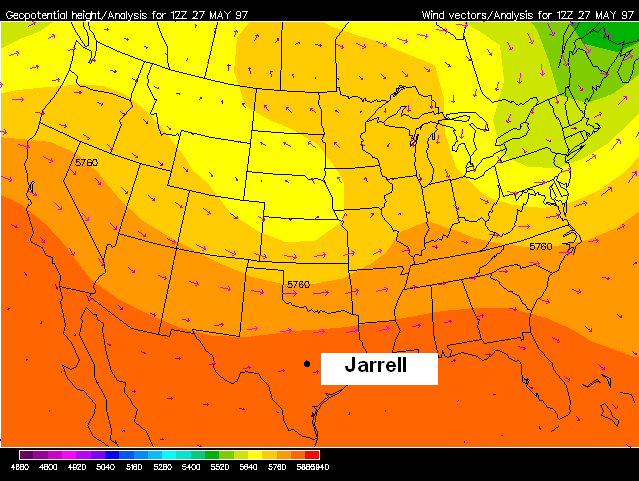
Figure 2. Radiosonde observations at Ft. Worth and Corpus Christi, TX, 1200 UTC 27 May 1997

SOME THOUGHTS ON THE ROLE MESOSCALE FEATURES PLAYED IN
THE 27 MAY 1997 CENTRAL TEXAS (JARRELL) TORNADO OUTBREAK
1. INTRODUCTION
Supercell thunderstorms spawned an outbreak of intense tornadoes over central Texas on the afternoon of 27 May 1997. Hardest hit was the area from just south of Waco to near Austin, where storms took nearly 30 lives and caused more than $125 million in damage (Storm Data 1997). An F5 tornado devastated the Double Creek subdivision near Jarrell, killing 27. Other storms with large hail and damaging winds extended east into Louisiana and south into the Lower Rio Grande Valley.
The 27 May event was unusual in that it occurred in an environment of comparatively weak vertical shear. The most significant upper-level feature of interest over the central United States was a 500 mb low centered well to the north over Nebraska (Figure 1). Mid-level westerly winds on the south side of the low decreased from around 30 kts over far northern Texas to less than 15 kts over the central and southern parts of the state. Boundary layer winds were quite light, reflecting the absence of a well-defined low-level jet. At the jet stream level, considerable divergence was present, enhanced perhaps by coupling between 250 mb speed maxima over northern Mexico and the mid Mississippi valley.
While the kinematic support for severe convection over central
Texas appeared somewhat weak, thermodynamically
conditions were quite favorable for intense thunderstorm
development. The 1200 UTC radiosonde data at both Corpus
Christi and Fort Worth exhibited a very deep elevated mixed
layer, with nearly dry adiabatic lapse rates present between 900
and 400 mb (Figure 2). After several days of onshore flow
and the suppression of deep convection (due to the elevated
mixed layer "cap"), boundary layer dewpoints were in the mid
70s (F), with the mean mixing ratio above 15 g/kg. These
conditions yielded surface-based cape in excess of 5500 J/kg
across nearly all of central and east Texas.
Figure 1. 500 mb analysis, 1200 UTC 27 May 1997
(Heights in dm; image courtesy of Plymouth State College)
Figure 2. Radiosonde observations at Ft. Worth and Corpus Christi, TX, 1200 UTC 27 May 1997
2. MESOSCALE SETUP
Although the thermodynamic environment on 27 May was very unstable, such conditions are not uncommon over central and east Texas in late spring. And, while the setup was certainly supportive of storms with both large hail and damaging winds, the threat for supercells was not obvious. The remainder of this discussion will focus on some aspects of the mesoscale environment, as revealed in the surface and upper air data, which may have played a role in fostering the development of supercellular convection.
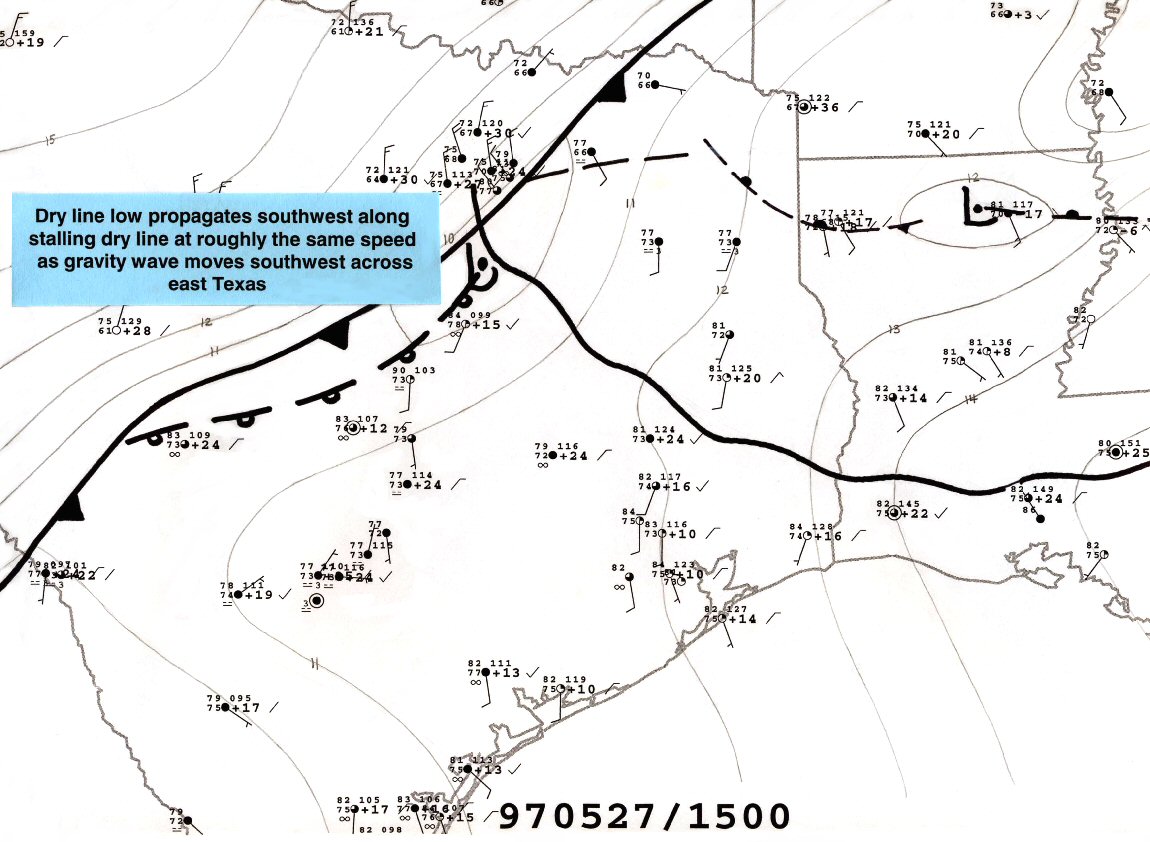
The hand analyses in Figures 3 and 4 show the evolution of surface features leading to the onset of severe convection on 27 May. Isobars are in two millibar intervals on the 0000, 0300, 0600, 0900 and 1200 UTC regional panels in Figure 3; one millibar increments are used on the succeeding hourly close-up charts of Figure 4. Synoptic and mesoscale features are depicted using a modified form of the convention suggested by Young and Fritsch (1989). The dry line is indicated by a series of open warm-front pips, and thunderstorm mesohighs by a "B" (for "bubble"). On the 1600-2100 UTC charts, developing convective cells are shown schematically as dark-colored blobs.
The central Texas supercells all developed in the vicinity of a cold front. This boundary was associated with the Nebraska upper low and had moved slowly southeast across the central plains during the previous two days. The western part of the front accelerated south in a series of "surges" across west Texas during the pre-dawn hours of the 27th, as shown in the 0000, 0300, 0600 and 0900 analyses. This acceleration likely reflected the advance of an upper level speed max from the central plains toward the mid Mississippi valley, and channeling of the low-level flow along the east slopes of the Rockies. By 1200 UTC, the cold front extended from southeast Oklahoma across the northwest side of the Dallas-Fort Worth region to near the Texas Big Bend.
In advance of the cold front, a dry line oriented along a NE/SW axis separated very moist boundary layer air over east Texas from drier air of continental origin farther west. As the light and variable winds on both sides of this feature would suggest, the dry line was nearly stationary on the morning of the 27th. Thunderstorms that initiated along the dry line over eastern Oklahoma the previous evening evolved into a large mesoscale convective system (MCS) that continued east across Arkansas later in the night. In addition to producing a series of strong mesohighs, the MCS generated a well-defined gravity wave that propagated southwest across the eastern half of Texas beginning around dawn on the 27th. The progress of the wave could be readily tracked via satellite as the capped mixed-layer cloudiness east of the dry line alternatingly thickened and thinned upon passage of the wave (not shown). The leading edge of the wave is depicted by a wavy line in the hourly surface charts.
The cold front gradually decelerated as it continued south across central Texas through the remainder of the morning. Because its advance remained greatest over the high plains, the front soon became parallel to the dry line to its south and east. At the same time, a weak dry line low which had been located over the Dallas area at 1200 UTC began to move southwest along the boundary. This movement appeared to occur at least partly in response to diabatic effects as maximum surface heating occurred in the narrowing wedge of clear air lying between the dry line and cold front.
Figure 3. Three-hourly regional mesoanalyses
(Conventional data plots; panel legends: YYMMDD/HHHH)

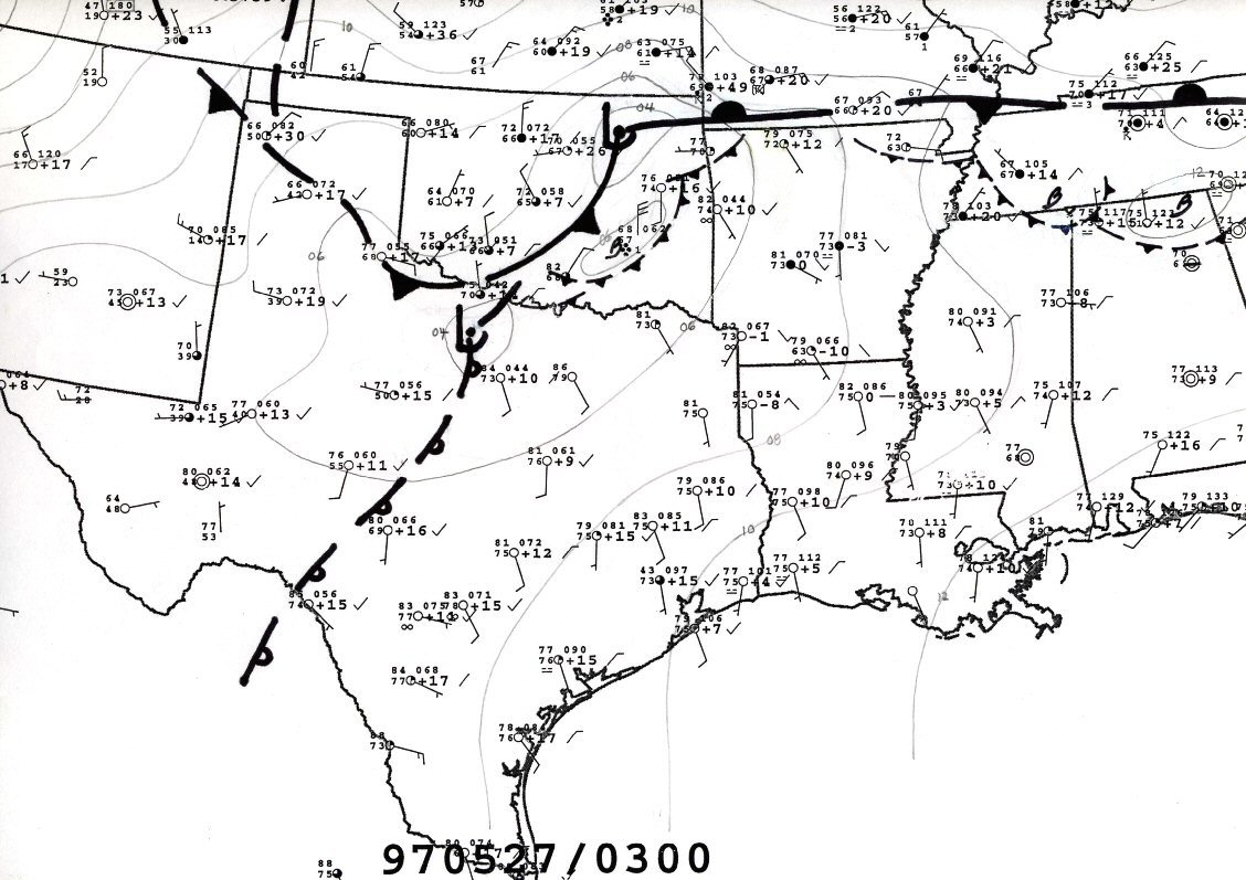


Figure 4. Hourly close-up mesoanalyses, with annotations
(Note: 1400 UTC not available due to data outage)


3. WHY SUPERCELLS?
Thunderstorms formed near Waco, TX in the vicinity of the dry line low around 1730 UTC. Objective analyses (not shown) indicate that regional maxima of both surface heating and surface moisture flux convergence were present near the low. In addition, as the 1500-1800 UTC analyses show, the low's southwestward track also marked the locus of points where the slowly-moving cold front overtook the nearly stationary dry line. Both boundaries could be observed for a brief time in the base reflectivity data taken by the Fort Hood/Granger, TX Doppler radar (Figure 5).
Coincidental with the onset of deep convection near Waco was the passage of the MCS-generated gravity wave. Having originated in Arkansas, the central Texas portion of this feature moved southwestward in-step with the surface wave until around 2100 UTC, at which time the cold front overtook the dry line near Austin. The advance of the gravity wave and its motion relative to the developing storms is readily apparent in the animated satellite imagery shown in Figure 6.
As previously noted, while the lower tropospheric environment over central Texas on the afternoon of 27 May 1997 was very unstable, such instability is certainly not unprecedented. The arrangement and behavior of mesoscale surface features was also not especially noteworthy: slowly-moving dry line/frontal mergers of the type observed occur in that region several times a year. Readily apparent gravity waves are also not uncommon in the area. Nevertheless, the fact that supercells continued to form over central Texas through much of the afternoon despite the presence of weak vertical shear suggests that some unusual circumstances were indeed coming into play. While a more conclusive answer must await careful modelling studies, it is the author's opinion that the fortuitous orientation and timing of the MCS-induced gravity wave, relative to both the slowly-moving surface boundaries and to the diurnal heating cycle, were critical in realizing and maintaining supercellular convection.
Although the lower tropospheric kinematic field appeared too weak to support "classical" supercell evolution, considerable vertically-oriented vorticity was in fact present in the vicinity of the merging cold front and dry line by the afternoon of the 27th (compare, for example, post-frontal and pre-dry line surface winds near Waco at 1200 and 1700 UTC). At the same time, the NE/SW orientation of the merging boundaries between Waco and Austin was, coincidentally, directly orthogonal to the southwest motion of the MCS-induced gravity wave.
Once surface heating and persistent convergence initiated convection near the surface low, the combination of strong updrafts (supported by the presence of very steep mid-level lapse rates), and increasing vertical vorticity in the vicinity of the front/dry line merger could conceivably have supported mid-level storm rotation. This is consistent with Magsig et al. (1998), who found that the mesocyclones on this day "grew from areas of deep convergence within large weak echo regions." What remains to be explained, however, is why the storms did not quickly become "outflow dominant" given (1) the limited degree of vertical shear and (2) the presence of a thermodynamic environment favorable for the production of strong downdrafts at the surface.
Since the support for "conventional" supercell propagation was weak, storm persistence was dependent upon the generation of new updrafts at a rate and in a direction such that the cells were not undercut by their own outflow. Because the merging cold front and dry line were oriented perpendicular to the gravity wave between Waco and Austin, it is speculated that the motion of the low-level pressure perturbation field associated with the wave was timed so as to favor new updraft development on the southwest side of existing cells just before these updrafts began to "gust out." The stout cap allowed storm development to only occur along the axis of strongest low-level mesoscale convergence; i.e., along the merging boundaries. The slow movement of the cold front (less than 5 m s-1) minimized the potential for "undercutting" of nascent updrafts by cool air north of the boundary. Coupled with the moderate westerly flow present at high levels (observed 300 mb winds were westerly at about 35 kts), the "forced" southwesterly storm redevelopment allowed precipitation from maturing updrafts to descend toward the east northeast, away from the direction of new updraft development. As a result of this unique set of circumstances, instead of falling victim to its own outflow, the original updraft near Waco was able to replicate itself southwestward along the dry line/cold front in a nearly continuous fashion.
West of Austin, both the cold front and dry line curved more to the west (see, for example, the 1800 UTC surface chart). Consequently, in this region, the gravity wave became oriented nearly parallel to the merging boundaries. Instead of fostering new updraft development in a limited area where the cap was locally breached, after 2000 UTC the wave's approach enhanced uplift almost simultaneously from near Austin west toward the Texas Big Bend. In addition, because of the wave's delayed arrival in south Texas relative to points farther north, surface heating initiated scattered convection along the boundaries prior to the arrival of the wave. This activity, while intense, quickly evolved into a largely non-supercellular, outflow-dominant complex as (1) downdrafts from adjacent cells joined to form large mesohighs, and (2) new updraft development was no longer focused in a direction away from storm outflow.
Figure 5. Base reflectivity display from Granger (Ft. Hood), TX doppler radar,
1840 UTC 27 May 1997

Figure 6. Visible data satellite loop,
1545-0045 UTC 27-28 May 1997

4. CONCLUSION
As has been shown, storm evolution during the 27 May 1997 central Texas tornado outbreak was very unusual. Given the fortuitous nature of the factors involved and, especially, the presence of an MCS-induced gravity wave, it is safe to say that another event of the same magnitude is not likely to occur for some time to come. It is, however, worth noting that meso-alpha scale environments similar to those that were present over central Texas on 27 May 1997 (slowly-moving boundary with weak shear, a strong cap and substantial potential instability) do occur with some regularity over the southern Plains, especially during late spring. For example, such a set-up, minus a gravity wave, yielded an F3 tornado over Lake Whitney, TX (approximately 30 miles northwest of Waco) on 12 May 2000. The central Texas tornadoes of 27 May 1997 serve as a reminder that there exist "unconventional" routes by which supercellular convection may be realized. These events can be problematic from a forecast perspective as they occur well beyond the more-commonly visited parts of severe weather parameter space. Clearly, even in the presence of weak shear, environments that foster strongly-deviant storm motions (see, for example, Johnson 2002) should be closely monitored for the potential of sustained, rotating convection when thermodynamic conditions are favorable for intense updrafts.
5. ACKNOWLEDGMENTS
The author would like to thank Richard Thompson and his other SPC colleagues for their instructive comments on this event. Sarah (Taylor) Corfidi is gratefully acknowledged for her HTML assistance.
6. REFERENCES
Johnson, Aaron W., 2002: A study of various thermodynamic and wind variables associated with tornadic supercells exhibiting atypical motion. (Available from NOAA-National Weather Service Central Region Headquarters, 7220 NW 101st Terrace, Kansas City, MO 64153, and at: http://www.crh.noaa.gov/crh/ssd/pdf/arp26-03.pdf)
Magsig, M. A., J. G. Ladue, D. W. Burgess, and R. R. Lee, 1998: Radar and satellite analysis of tornadic storm updraft evolution on 27 May 1997. Preprints, 16th Conf. On Weather Analysis and Forecasting, Phoenix, Amer. Meteor. Soc., 320-322.
Young, G. S., and J. M. Fritsch, 1989: A proposal for general conventions in analysis of mesoscale boundaries. Bull. Amer. Meteor. Soc., 70, 1412-1421.