Note:
The expiration time in the watch graphic is amended if the watch is
replaced, cancelled or extended.
Note:
Note:
The expiration time in the watch graphic is amended if the watch is
replaced, cancelled or extended.
Note: Click for
Watch Status Reports.
SEL0
URGENT - IMMEDIATE BROADCAST REQUESTED
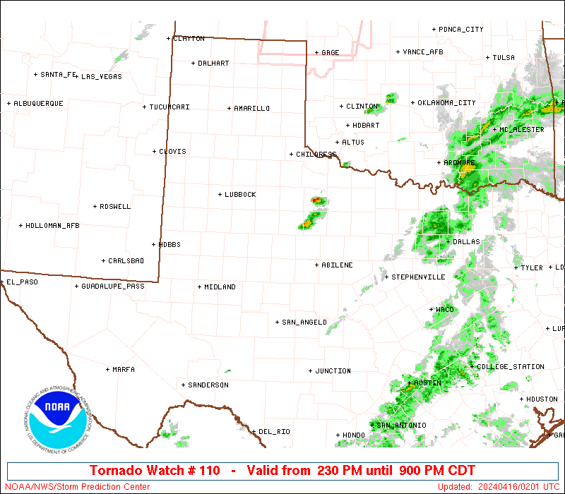
Tornado Watch Number 110
NWS Storm Prediction Center Norman OK
230 PM CDT Mon Apr 15 2024
The NWS Storm Prediction Center has issued a
* Tornado Watch for portions of
Southwest Oklahoma
Northwest Texas
* Effective this Monday afternoon and evening from 230 PM until
900 PM CDT.
* Primary threats include...
A couple tornadoes possible
Scattered large hail and isolated very large hail events to 3
inches in diameter likely
Scattered damaging winds and isolated significant gusts to 75
mph possible
SUMMARY...Severe thunderstorms are expected to develop in the next 1
to 2 hours across northwest Texas and shift east through early
evening. Large hail and damaging gusts are possible initially, with
an increasing tornado risk expected during the evening.
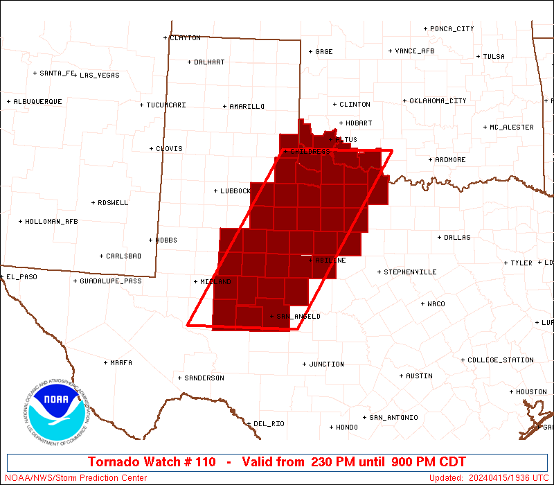
The tornado watch area is approximately along and 70 statute miles
east and west of a line from 40 miles west southwest of San Angelo
TX to 50 miles northwest of Wichita Falls TX. For a complete
depiction of the watch see the associated watch outline update
(WOUS64 KWNS WOU0).
PRECAUTIONARY/PREPAREDNESS ACTIONS...
REMEMBER...A Tornado Watch means conditions are favorable for
tornadoes and severe thunderstorms in and close to the watch
area. Persons in these areas should be on the lookout for
threatening weather conditions and listen for later statements
and possible warnings.
&&
OTHER WATCH INFORMATION...CONTINUE...WW 109...
AVIATION...Tornadoes and a few severe thunderstorms with hail
surface and aloft to 3 inches. Extreme turbulence and surface wind
gusts to 65 knots. A few cumulonimbi with maximum tops to 500. Mean
storm motion vector 24035.
...Leitman

   SEL0

   URGENT - IMMEDIATE BROADCAST REQUESTED
   Tornado Watch Number 110
   NWS Storm Prediction Center Norman OK
   230 PM CDT Mon Apr 15 2024

   The NWS Storm Prediction Center has issued a

   * Tornado Watch for portions of
     Southwest Oklahoma
     Northwest Texas

   * Effective this Monday afternoon and evening from 230 PM until
     900 PM CDT.

   * Primary threats include...
     A couple tornadoes possible
     Scattered large hail and isolated very large hail events to 3
       inches in diameter likely
     Scattered damaging winds and isolated significant gusts to 75
       mph possible

   SUMMARY...Severe thunderstorms are expected to develop in the next 1
   to 2 hours across northwest Texas and shift east through early
   evening. Large hail and damaging gusts are possible initially, with
   an increasing tornado risk expected during the evening.

   The tornado watch area is approximately along and 70 statute miles
   east and west of a line from 40 miles west southwest of San Angelo
   TX to 50 miles northwest of Wichita Falls TX. For a complete
   depiction of the watch see the associated watch outline update
   (WOUS64 KWNS WOU0).

   PRECAUTIONARY/PREPAREDNESS ACTIONS...

   REMEMBER...A Tornado Watch means conditions are favorable for
   tornadoes and severe thunderstorms in and close to the watch
   area. Persons in these areas should be on the lookout for
   threatening weather conditions and listen for later statements
   and possible warnings.

   &&

   OTHER WATCH INFORMATION...CONTINUE...WW 109...

   AVIATION...Tornadoes and a few severe thunderstorms with hail
   surface and aloft to 3 inches. Extreme turbulence and surface wind
   gusts to 65 knots. A few cumulonimbi with maximum tops to 500. Mean
   storm motion vector 24035.

   ...Leitman
 Note:
The Aviation Watch (SAW) product is an approximation to the watch area.
The actual watch is depicted by the shaded areas.
Note:
The Aviation Watch (SAW) product is an approximation to the watch area.
The actual watch is depicted by the shaded areas.
   SAW0
   WW 110 TORNADO OK TX 151930Z - 160200Z
   AXIS..70 STATUTE MILES EAST AND WEST OF LINE..
   40WSW SJT/SAN ANGELO TX/ - 50NW SPS/WICHITA FALLS TX/
   ..AVIATION COORDS.. 60NM E/W /37WSW SJT - 40NW SPS/
   HAIL SURFACE AND ALOFT..3 INCHES. WIND GUSTS..65 KNOTS.
   MAX TOPS TO 500. MEAN STORM MOTION VECTOR 24035.

   LAT...LON 31140231 34470035 34479789 31149994

   THIS IS AN APPROXIMATION TO THE WATCH AREA.  FOR A
   COMPLETE DEPICTION OF THE WATCH SEE WOUS64 KWNS
   FOR WOU0.
Watch 110 Status Report Messages:
STATUS REPORT #3 ON WW 110
VALID 160040Z - 160140Z
SEVERE WEATHER THREAT CONTINUES RIGHT OF A LINE FROM 50 WSW SJT
TO 35 ESE LBB.
..LYONS..04/16/24
ATTN...WFO...OUN...MAF...SJT...LUB...FWD...
&&
STATUS REPORT FOR WT 110
SEVERE WEATHER THREAT CONTINUES FOR THE FOLLOWING AREAS
OKC033-055-057-065-075-141-160140-
OK
. OKLAHOMA COUNTIES INCLUDED ARE
COTTON GREER HARMON
JACKSON KIOWA TILLMAN
$$
TXC009-023-059-075-077-081-101-125-151-155-197-207-235-253-263-
269-275-335-353-399-415-417-429-431-433-441-447-451-485-487-503-
160140-
TX
. TEXAS COUNTIES INCLUDED ARE
ARCHER BAYLOR CALLAHAN
CHILDRESS CLAY COKE
COTTLE DICKENS FISHER
FOARD HARDEMAN HASKELL
IRION JONES KENT
KING KNOX MITCHELL
NOLAN RUNNELS SCURRY
SHACKELFORD STEPHENS STERLING
STONEWALL TAYLOR THROCKMORTON
TOM GREEN WICHITA WILBARGER
YOUNG
$$
THE WATCH STATUS MESSAGE IS FOR GUIDANCE PURPOSES ONLY. PLEASE
REFER TO WATCH COUNTY NOTIFICATION STATEMENTS FOR OFFICIAL
INFORMATION ON COUNTIES...INDEPENDENT CITIES AND MARINE ZONES
CLEARED FROM SEVERE THUNDERSTORM AND TORNADO WATCHES.
$$
STATUS REPORT #2 ON WW 110
VALID 152335Z - 160040Z
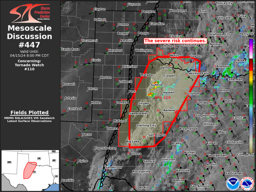
SEVERE WEATHER THREAT CONTINUES RIGHT OF A LINE FROM 60 WSW SJT
TO 55 WSW SJT TO 15 NNE BGS TO 50 N BGS TO 50 SSE LBB.
FOR ADDITIONAL INFORMATION SEE MESOSCALE DISCUSSION 447
..SQUITIERI..04/15/24
ATTN...WFO...OUN...MAF...SJT...LUB...FWD...
&&
STATUS REPORT FOR WT 110
SEVERE WEATHER THREAT CONTINUES FOR THE FOLLOWING AREAS
OKC033-057-065-141-160040-
OK
. OKLAHOMA COUNTIES INCLUDED ARE
COTTON HARMON JACKSON
TILLMAN
$$
TXC009-023-059-075-077-081-101-125-151-155-197-207-235-253-263-
269-275-335-353-399-415-417-429-431-433-441-447-451-485-487-503-
160040-
TX
. TEXAS COUNTIES INCLUDED ARE
ARCHER BAYLOR CALLAHAN
CHILDRESS CLAY COKE
COTTLE DICKENS FISHER
FOARD HARDEMAN HASKELL
IRION JONES KENT
KING KNOX MITCHELL
NOLAN RUNNELS SCURRY
SHACKELFORD STEPHENS STERLING
STONEWALL TAYLOR THROCKMORTON
TOM GREEN WICHITA WILBARGER
YOUNG
$$
THE WATCH STATUS MESSAGE IS FOR GUIDANCE PURPOSES ONLY. PLEASE
REFER TO WATCH COUNTY NOTIFICATION STATEMENTS FOR OFFICIAL
INFORMATION ON COUNTIES...INDEPENDENT CITIES AND MARINE ZONES
CLEARED FROM SEVERE THUNDERSTORM AND TORNADO WATCHES.
$$
STATUS REPORT #1 ON WW 110
VALID 152120Z - 152240Z
THE SEVERE WEATHER THREAT CONTINUES ACROSS THE ENTIRE WATCH AREA.
..SQUITIERI..04/15/24
ATTN...WFO...OUN...MAF...SJT...LUB...FWD...
&&
STATUS REPORT FOR WT 110
SEVERE WEATHER THREAT CONTINUES FOR THE FOLLOWING AREAS
OKC033-057-065-141-152240-
OK
. OKLAHOMA COUNTIES INCLUDED ARE
COTTON HARMON JACKSON
TILLMAN
$$
TXC009-023-033-059-075-077-081-101-125-151-155-173-197-207-227-
235-253-263-269-275-335-353-383-399-415-417-429-431-433-441-447-
451-485-487-503-152240-
TX
. TEXAS COUNTIES INCLUDED ARE
ARCHER BAYLOR BORDEN
CALLAHAN CHILDRESS CLAY
COKE COTTLE DICKENS
FISHER FOARD GLASSCOCK
HARDEMAN HASKELL HOWARD
IRION JONES KENT
KING KNOX MITCHELL
NOLAN REAGAN RUNNELS
SCURRY SHACKELFORD STEPHENS
STERLING STONEWALL TAYLOR
THROCKMORTON TOM GREEN WICHITA
WILBARGER YOUNG
$$
THE WATCH STATUS MESSAGE IS FOR GUIDANCE PURPOSES ONLY. PLEASE
REFER TO WATCH COUNTY NOTIFICATION STATEMENTS FOR OFFICIAL
INFORMATION ON COUNTIES...INDEPENDENT CITIES AND MARINE ZONES
CLEARED FROM SEVERE THUNDERSTORM AND TORNADO WATCHES.
$$
Note:
Click for Complete Product Text.
Tornadoes
Probability of 2 or more tornadoes
|
Mod (40%)
|
Probability of 1 or more strong (EF2-EF5) tornadoes
|
Low (20%)
|
Wind
Probability of 10 or more severe wind events
|
Mod (40%)
|
Probability of 1 or more wind events > 65 knots
|
Mod (30%)
|
Hail
Probability of 10 or more severe hail events
|
Mod (60%)
|
Probability of 1 or more hailstones > 2 inches
|
Mod (60%)
|
Combined Severe Hail/Wind
Probability of 6 or more combined severe hail/wind events
|
High (90%)
|
For each watch, probabilities for particular events inside the watch
(listed above in each table) are determined by the issuing forecaster.
The "Low" category contains probability values ranging from less than 2%
to 20% (EF2-EF5 tornadoes), less than 5% to 20% (all other probabilities),
"Moderate" from 30% to 60%, and "High" from 70% to greater than 95%.
High values are bolded and lighter in color to provide awareness of
an increased threat for a particular event.


 @NWSSPC