Kansas City, MO...Overland Park, KS...Springfield, MO...Kansas City, KS...Topeka, KS...
MARGINAL
422,849
49,861,291
Philadelphia, PA...Memphis, TN...Baltimore, MD...Washington, DC...Oklahoma City, OK...
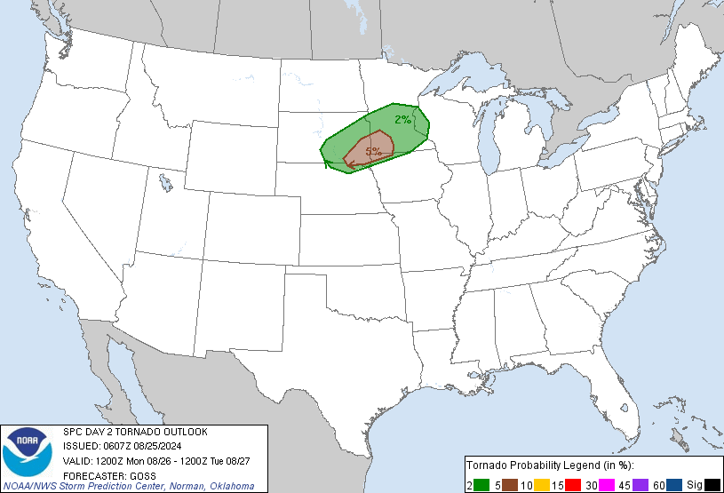
Probabilistic Tornado Graphic
Probability of a tornado within 25 miles of a point. Hatched Area: 10% or greater probability of EF2 - EF5 tornadoes within 25 miles of a point.
Day 2 Tornado Risk
Area (sq. mi.)
Area Pop.
Some Larger Population Centers in Risk Area
2 %
77,833
5,707,346
Kansas City, MO...Des Moines, IA...Overland Park, KS...Kansas City, KS...Topeka, KS...
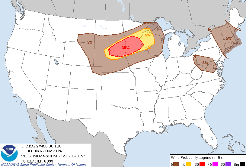
Probabilistic Damaging Wind Graphic
Probability of damaging thunderstorm winds or wind gusts of 50 knots or higher within 25 miles of a point. Hatched Area: 10% of greater probability of wind gusts 65 knots or greater within 25 miles of a point.
Day 2 Wind Risk
Area (sq. mi.)
Area Pop.
Some Larger Population Centers in Risk Area
15 %
77,667
6,079,039
Kansas City, MO...Overland Park, KS...Springfield, MO...Kansas City, KS...Topeka, KS...
5 %
422,934
49,896,355
Philadelphia, PA...Memphis, TN...Baltimore, MD...Washington, DC...Oklahoma City, OK...
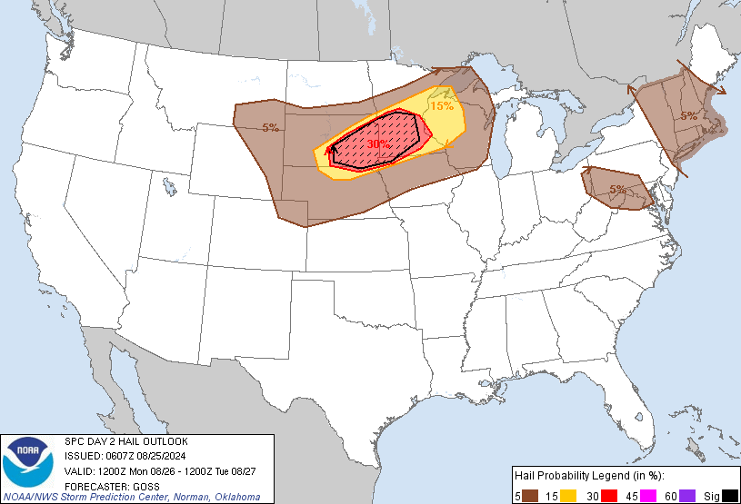
Probabilistic Large Hail Graphic
Probability of hail 1" or larger within 25 miles of a point. Hatched Area: 10% or greater probability of hail 2" or larger within 25 miles of a point.
Day 2 Hail Risk
Area (sq. mi.)
Area Pop.
Some Larger Population Centers in Risk Area
5 %
145,723
12,519,820
Kansas City, MO...Minneapolis, MN...St. Paul, MN...Des Moines, IA...Overland Park, KS...
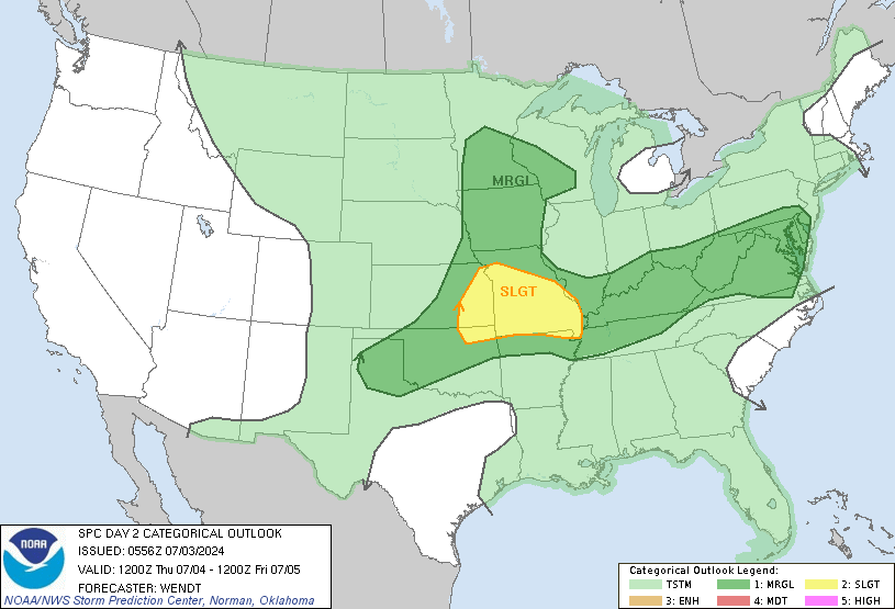
   SPC AC 030556

   Day 2 Convective Outlook
   NWS Storm Prediction Center Norman OK
   1256 AM CDT Wed Jul 03 2024

   Valid 041200Z - 051200Z

   ...THERE IS A SLIGHT RISK OF SEVERE THUNDERSTORMS EASTERN
   KANSAS...NORTHEAST OKLAHOMA...PORTIONS OF MISSOURI...

   ...SUMMARY...
   Severe thunderstorms will be possible on Independence Day, mainly
   across the Lower Missouri Valley, Ozarks, and south-central Plains.

   ...Synopsis...
   A strong upper-level trough for this time of year will dig into the
   central Rockies/Plains by early Thursday morning. This trough will
   slow and intensify across portions of the mid Missouri/Mississippi
   Valleys by the afternoon. As this occurs, an upper low will deepen
   in the upper Midwest. At the surface, a remnant boundary will be
   positioned roughly from the southern Plains into the upper Ohio
   Valley/Mid-Atlantic. 70s F dewpoints will reside south of this
   boundary. Through the day, a modest surface low is forecast to
   develop in the Iowa/Minnesota border vicinity. This will draw at
   least mid 60s F dewpoints northward into the region. Ongoing
   convection early Thursday will have an impact on where the most
   favorable areas for severe weather will be by the afternoon.
   Convection from Missouri into much of the Ohio Valley will slow the
   northward return of moisture and leave outflow boundaries.
   Additional activity seems likely closely tied to the shortwave
   trough/developing upper low into portions of the Missouri Valley.

   ...Eastern Kansas...northeast Oklahoma...Missouri...
   Early convection is expected to move out of the region by the
   afternoon. Strong heating ahead of the cold front that will
   eventually push into eastern Kansas/Missouri and near whatever
   composite front/outflow is left from the earlier storms will yield
   2500-3000 J/kg MLCAPE. Effective shear will be weaker with southern
   extent, but 40-45 kts is possible in central/southeastern Missouri
   into southeast Kansas. Mid-level ascent will be quite modest, but
   storms are expected to develop along the cold front and potentially
   along the outflow farther east. Initial storms would be supercells
   capable of large hail and damaging winds. While low-level shear will
   be weak, a tornado could occur with discrete storms favorably
   interacting with the outflow boundary in particular. Upscale growth
   will likely occur fairly quickly given the boundary-parallel
   deep-layer shear along the cold front. Wind damage would become more
   common as a potential MCS would move into large buoyancy.

   ...Upper Midwest...
   Uncertainty in the degree of destabilization remains rather high as
   there will be potential for cloud cover from activity to the west
   and south. Storm development is most likely to occur along the cold
   front moving through Iowa given the greater forcing for ascent. Less
   certain is development into western/central Wisconsin along a weak
   warm front. Temperatures aloft will support some potential for
   marginally severe hail. Isolated damaging winds will be possible as
   well, but this, again, will largely depend on how steep low-level
   lapse rates can become. Though the threat is low and uncertain, a
   tornado would be possible if sufficient destabilization can occur in
   Iowa. Low-level shear would be maximized near the surface low, and
   deep-layer shear across the initiating boundary would mean discrete
   storms for at least a short duration.

   ...Southern Plains...
   Strong heating south of the boundary (mid 90s to potentially low
   100s F) will promote 1500-2500 J/kg MLCAPE by the afternoon. Heating
   plus convergence along the front give reasonable confidence in
   widely scattered to scattered storms. Storms will only be modestly
   organized given the area will be on the extreme southern periphery
   of stronger mid-level winds. Activity will likely grow upscale and
   push southward until MLCIN increases. Severe/damaging winds will be
   the primary concern.

   ...Ohio Valley into Mid-Atlantic...
   Convection appears likely to be ongoing along the surface boundary
   due to modest mid-level ascent and low-level warm advection. South
   of the boundary, a very moist airmass will be in place. Additional
   stronger activity will be possible either along the boundary itself
   or along outflow from earlier storms. Deep-layer shear will be weak
   except right along/north of the boundary, but a few damaging
   microbursts will be possible due to the moderate to strong buoyancy
   and steep low-level lapse rates in cloud-free areas.

   ..Wendt.. 07/03/2024

   NOTE: THE NEXT DAY 2 OUTLOOK IS SCHEDULED BY 1730Z