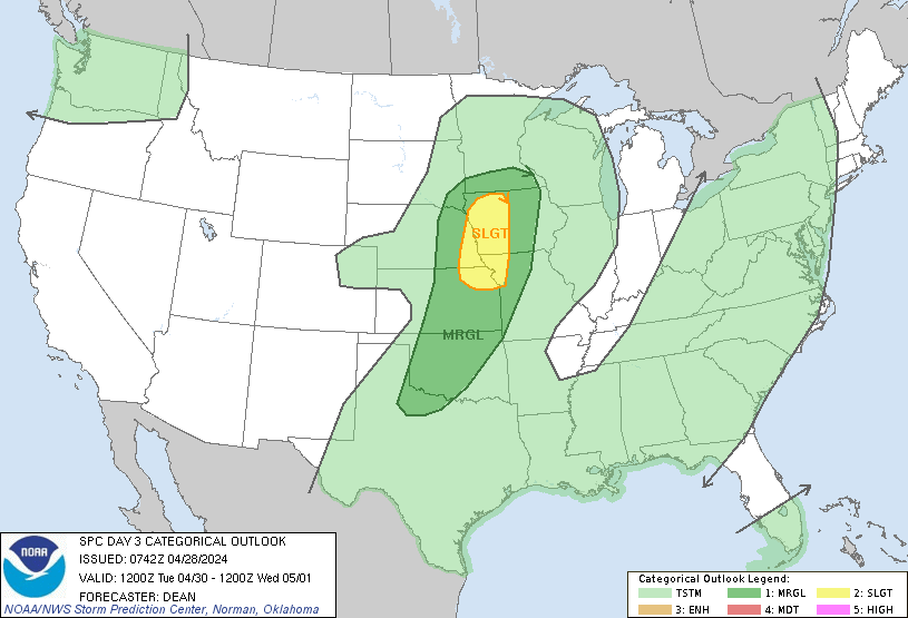
Kansas City, MO...Omaha, NE...Lincoln, NE...Kansas City, KS...Topeka, KS...
MARGINAL
166,291
9,178,984
Oklahoma City, OK...Tulsa, OK...Wichita, KS...Des Moines, IA...Overland Park, KS...
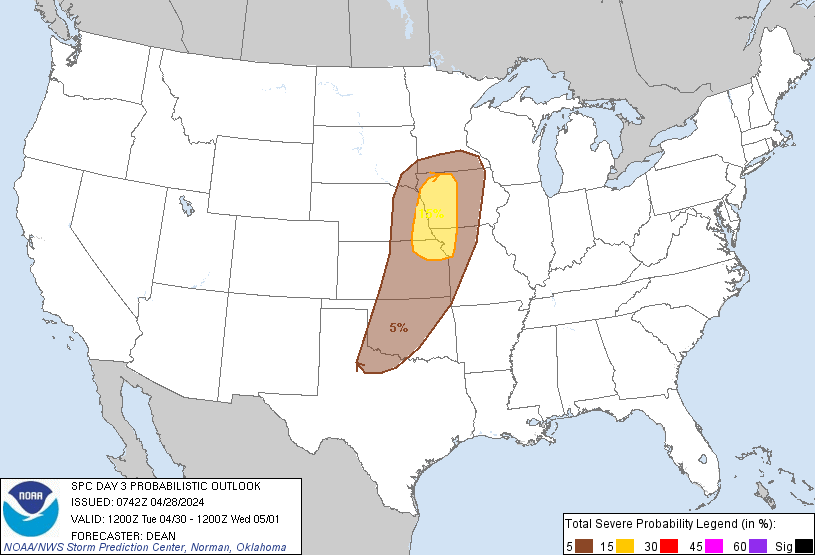
Probabilistic Graphic
Probability of severe weather within 25 miles of a point. Hatched Area: 10% or greater probability of significant severe within 25 miles of a point.
Day 3 Prob. Risk
Area (sq. mi.)
Area Pop.
Some Larger Population Centers in Risk Area
15 %
42,166
2,924,972
Kansas City, MO...Omaha, NE...Lincoln, NE...Kansas City, KS...Topeka, KS...
5 %
166,268
9,249,509
Oklahoma City, OK...Tulsa, OK...Wichita, KS...Des Moines, IA...Overland Park, KS...
   SPC AC 280742

   Day 3 Convective Outlook
   NWS Storm Prediction Center Norman OK
   0242 AM CDT Sun Apr 28 2024

   Valid 301200Z - 011200Z

   ...THERE IS A SLIGHT RISK OF SEVERE THUNDERSTORMS FOR EASTERN
   NE...WESTERN IA...NORTHWEST MO...NORTHEAST KS...

   ...SUMMARY...
   Severe thunderstorms will be possible on Tuesday from parts of the
   mid/upper Mississippi Valley into the central/southern Plains.

   ...Synopsis...
   An amplified mid/upper-level shortwave trough is forecast to move
   eastward from the northern Rockies into parts of the
   northern/central Plains on Tuesday, accompanied by a strong
   mid/upper-level jet. A surface wave is forecast to move from the
   central Plains toward the upper MS Valley, with a separate low
   expected to largely remain in place across the southern High Plains.

   ...Upper MS Valley into the southern Plains...
   Low-level moisture will stream northward through the day from the
   southern Plains into the central Plains and upper MS Valley, in
   response to the approaching shortwave trough. While the richest
   moisture will likely remain displaced southward of the shortwave
   track, 50s to near 60F dewpoints could spread as far north as
   eastern NE/western IA and southern MN by Tuesday afternoon. This
   moistening beneath relatively steep midlevel lapse rates will
   support diurnal destabilization, with peak MLCAPE ranging from
   around 500 J/kg across southern MN to greater than 1500 J/kg across
   the southern Plains.

   Thunderstorm development is expected along a weak cold front Tuesday
   afternoon, as diurnal heating weakens MLCINH. The greatest coverage
   of storms and strongest deep-layer shear are expected from southern
   MN into parts of eastern NE and western IA, in closer proximity to
   stronger ascent attendant to the shortwave. A few stronger
   cells/clusters will be possible, capable of producing large hail,
   damaging winds, and possibly a tornado or two. Storm coverage and
   deep-layer shear will likely decrease with southward extent, though
   stronger instability into parts of KS/OK could support at least an
   isolated severe thunderstorm threat during the afternoon and
   evening.

   A Slight Risk has been added where confidence is greatest in overlap
   of greater storm coverage and shear with more favorable instability.

   ..Dean.. 04/28/2024

   CLICK TO GET WUUS03 PTSDY3 PRODUCT

   NOTE: THE NEXT DAY 3 OUTLOOK IS SCHEDULED BY 0730Z