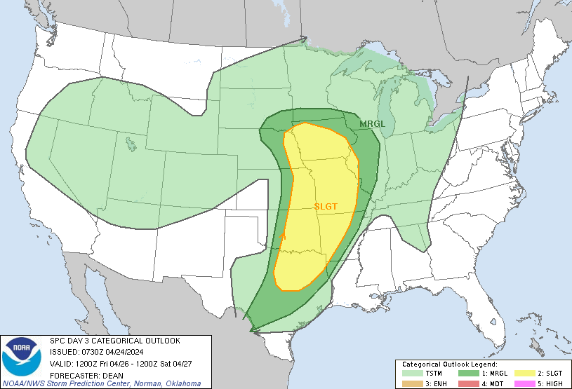
Dallas, TX...Fort Worth, TX...Oklahoma City, OK...Kansas City, MO...Omaha, NE...
MARGINAL
199,313
16,062,242
San Antonio, TX...Austin, TX...Wichita, KS...St. Louis, MO...Madison, WI...
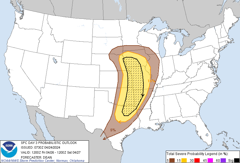
Probabilistic Graphic
Probability of severe weather within 25 miles of a point. Hatched Area: 10% or greater probability of significant severe within 25 miles of a point.
Day 3 Prob. Risk
Area (sq. mi.)
Area Pop.
Some Larger Population Centers in Risk Area
SIG SEVERE
124,297
12,879,536
Dallas, TX...Kansas City, MO...Omaha, NE...Arlington, TX...Plano, TX...
15 %
253,097
23,088,835
Dallas, TX...Fort Worth, TX...Oklahoma City, OK...Kansas City, MO...Omaha, NE...
5 %
198,656
16,052,317
San Antonio, TX...Austin, TX...Wichita, KS...St. Louis, MO...Madison, WI...
   SPC AC 240730

   Day 3 Convective Outlook
   NWS Storm Prediction Center Norman OK
   0230 AM CDT Wed Apr 24 2024

   Valid 261200Z - 271200Z

   ...THERE IS A SLIGHT RISK OF SEVERE THUNDERSTORMS FOR PARTS OF THE
   CENTRAL/SOUTHERN GREAT PLAINS INTO THE MID MISSISSIPPI VALLEY AND
   OZARKS...

   ...SUMMARY...
   An active severe weather day appears possible on Friday from parts
   of Nebraska and Iowa southward into parts of the southern Great
   Plains and Ozarks. A few tornadoes, large to very large hail, and
   damaging winds will all be possible.

   ...Synopsis...
   A negatively tilted mid/upper-level shortwave trough and associated
   occluding surface low are forecast to move northeastward toward the
   upper Great Lakes from Friday into Friday night. A trailing Pacific
   front/dryline will move eastward through the day across the
   central/southern Plains, before retreating westward Friday night. A
   warm front will move northward in advance of the surface low across
   MO into parts of IA, though its progress may be slowed by convective
   outflow resulting from extensive D2/Thursday convection.

   ...Central/southern Plains into the mid MS Valley...
   A relatively active severe weather day appears possible from eastern
   portions of the Great Plains into parts of the mid MS Valley and
   Ozarks on Friday. However, uncertainty remains regarding the impact
   of extensive antecedent convection on the quality of the warm
   sector.

   Thunderstorms that develop late on D2/Thursday may be ongoing during
   the morning from eastern KS into central/eastern OK and north TX. At
   least some severe threat may persist through the morning with this
   convection, as it spreads into parts of MO/AR. With favorable
   deep-layer shear across the warm sector, some intensification of
   early convection will be possible during the afternoon, though there
   may be a tendency for storms to move eastward out of the primary
   instability axis. The strongest storms across eastern portions of
   the warm sector could pose at least some threat for all severe
   hazards, though magnitude of the threat remains uncertain.

   With the dryline not expected to make a strong eastward push, some
   redevelopment cannot be ruled out later in the day. Depending on
   heating and destabilization trends, supercell development will be
   possible from eastern NE/western IA southward into the ArkLaTex
   region. Large hail (potentially in excess of 2 inches in diameter)
   and could accompany any supercell development in this area, given
   the persistence of rich low-level moisture beneath steep midlevel
   lapse rates. Persistent moderate to strong low-level flow/shear will
   also support tornado potential, especially if supercells can be
   sustained near the ejecting shortwave and surface low across
   northern portions of the risk area.

   Southwestward extent of the severe threat during the
   afternoon/evening remains uncertain. Development cannot be entirely
   ruled out from central OK into north/central TX along the nearly
   stalled dryline, though coverage would likely remain very isolated
   in the wake of the departing shortwave trough.

   ..Dean.. 04/24/2024

   CLICK TO GET WUUS03 PTSDY3 PRODUCT

   NOTE: THE NEXT DAY 3 OUTLOOK IS SCHEDULED BY 0730Z