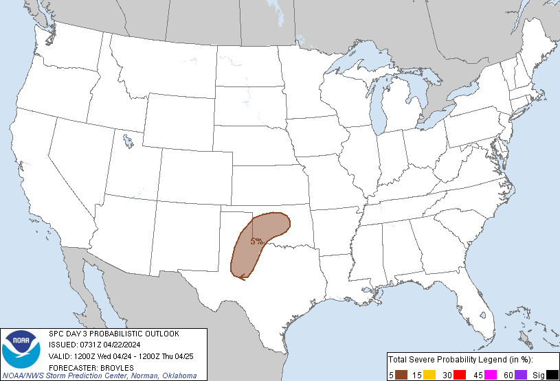
Oklahoma City, OK...Norman, OK...Lawton, OK...Edmond, OK...Midwest City, OK...
Probabilistic Graphic
Probability of severe weather within 25 miles of a point. Hatched Area: 10% or greater probability of significant severe within 25 miles of a point.
Day 3 Prob. Risk
Area (sq. mi.)
Area Pop.
Some Larger Population Centers in Risk Area
5 %
52,333
2,009,303
Oklahoma City, OK...Norman, OK...Lawton, OK...Edmond, OK...Midwest City, OK...
SPC AC 220731
Day 3 Convective Outlook
NWS Storm Prediction Center Norman OK
0231 AM CDT Mon Apr 22 2024
Valid 241200Z - 251200Z
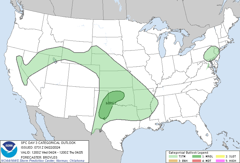
...THERE IS A MARGINAL RISK OF SEVERE THUNDERSTORMS ACROSS PARTS OF
THE SOUTHERN PLAINS...
...SUMMARY...
Isolated thunderstorms, associated with a marginal threat for strong
wind gusts and hail, will be possible on Wednesday across parts of
the southern Plains.
...Southern Plains...
An upper-level ridge is forecast to move eastward into the High
Plains on Wednesday, as flow at mid-levels remains
west-northwesterly across the southern Plains. At the surface, a
moist airmass will be in place across much of Texas into Oklahoma,
with a warm front located from west Texas Panhandle eastward into
central Oklahoma. South of the front, surface dewpoints will be in
the 60s F. A north-to-south corridor of moderate instability is
expected to develop across west Texas during the day, with weaker
instability extending eastward across much of Texas and Oklahoma.
Forecast soundings near the instability axis in west Texas during
the late afternoon suggest that a capping inversion will be in
place. The cap could weaken enough in areas that heat up the most,
to allow for isolated convective development. Forecast soundings
near Midland and Lubbock by 00Z/Thursday have MLCAPE peaking near
2000 J/kg, 0-6 km shear at 40 knots and steep mid-level lapse rates.
If a cell can overcome the cap, then isolated supercell development
would be possible, with a threat for hail and strong wind gusts.
This threat is highly conditional.
Further northeast along the warm front in central Oklahoma, some
model solutions suggest that elevated storms will develop during the
afternoon or evening. Forecast sounding in central Oklahoma have
MUCAPE near 1500 J/kg, with effective shear around 50 knots. This
could be enough for a marginal hail threat.
..Broyles.. 04/22/2024
CLICK TO GET WUUS03 PTSDY3 PRODUCT
NOTE: THE NEXT DAY 3 OUTLOOK IS SCHEDULED BY 0730Z