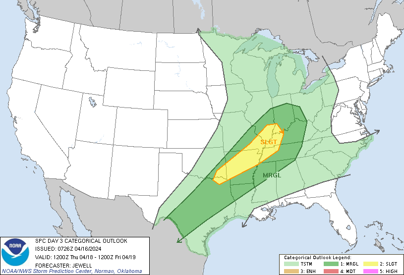
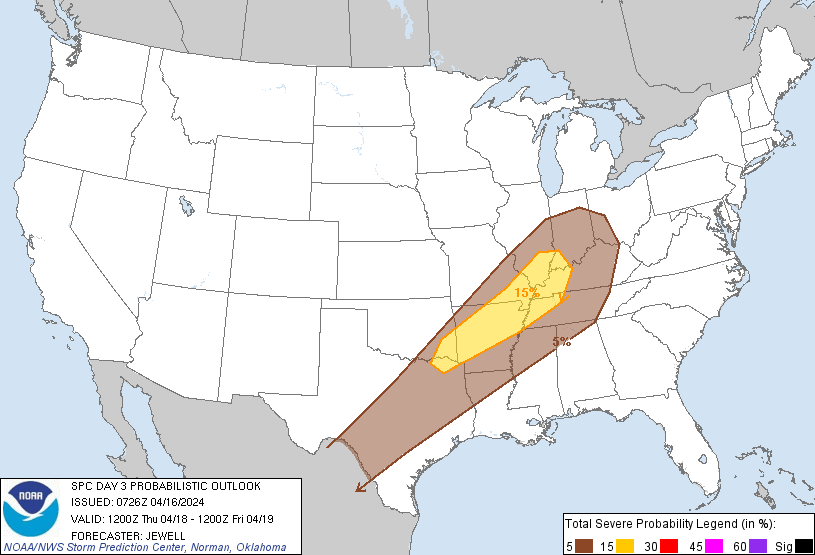
Memphis, TN...Little Rock, AR...Evansville, IN...Clarksville, TN...Jackson, TN...
MARGINAL
266,067
34,021,812
San Antonio, TX...Dallas, TX...Indianapolis, IN...Austin, TX...Fort Worth, TX...
Probabilistic Graphic
Probability of severe weather within 25 miles of a point. Hatched Area: 10% or greater probability of significant severe within 25 miles of a point.
Day 3 Prob. Risk
Area (sq. mi.)
Area Pop.
Some Larger Population Centers in Risk Area
15 %
83,284
5,095,572
Memphis, TN...Little Rock, AR...Evansville, IN...Clarksville, TN...Jackson, TN...
5 %
267,908
34,226,521
San Antonio, TX...Dallas, TX...Indianapolis, IN...Austin, TX...Fort Worth, TX...
   SPC AC 160726

   Day 3 Convective Outlook
   NWS Storm Prediction Center Norman OK
   0226 AM CDT Tue Apr 16 2024

   Valid 181200Z - 191200Z

   ...THERE IS A SLIGHT RISK OF SEVERE THUNDERSTORMS FROM THE ARKLATEX
   REGION NORTHEASTWARD INTO THE LOWER OHIO VALLEY...

   ...SUMMARY...
   Scattered strong to severe storms capable of gusty winds and hail
   will be possible Thursday from parts of Texas northeastward toward
   the Ohio Valley.

   ...Synopsis...
   An upper low will deepen over western Ontario on Thursday as a broad
   upper trough moves eastward across the northern Plains, upper MS
   Valley and upper Great Lakes. An extensive and tight midlevel
   temperature gradient will exist, with the core of the strongest
   midlevel winds from WY across NE and into WI and Upper MI.

   At the surface, a prominent cold front will continue southward
   across the Plains, reaching central TX by afternoon, and extending
   northeastward across the Ozarks and into IL and IN by 00Z. A weak
   low/trough will exist from OK/TX toward IN ahead of the front, with
   perhaps a wave or two translating northeastward along the boundary.

   Ahead of the cold front and in advance of the northern trough,
   southwest winds around 850 mb will aid theta-e advection across the
   Mid/Lower MS Valley and across the OH Valley, with speeds around 30
   kt likely. Dewpoints of 60-65 F will be common ahead of the front
   from IN southwestward, with values near 70 F from TX into AR.
   Favorable instability for strong to severe storms may exist along
   the length of the boundary, but threat corridors are uncertain at
   time given differences in model output.

   ...Northeast TX/Eastern OK to the Ohio Valley...
   An expansive area of moisture and instability will favor
   thunderstorms on Thursday, through shear will be weak over southern
   areas. Substantial model differences exist regarding favored areas
   of severe storm threat, but the northern extent of the stronger
   instability may support relatively greater potential closer to the
   upper trough. Overall, the most favorable combination of lift,
   instability and shear looks to be roughly from the ArkLaTex into
   southern IL/IN. A capping inversion may suppress development until
   peak heating over southern areas, while northern areas develop a bit
   earlier in the afternoon. Both hail and wind are anticipated.

   ..Jewell.. 04/16/2024

   CLICK TO GET WUUS03 PTSDY3 PRODUCT

   NOTE: THE NEXT DAY 3 OUTLOOK IS SCHEDULED BY 0730Z