SPC AC 140732
Day 3 Convective Outlook
NWS Storm Prediction Center Norman OK
0232 AM CDT Sun Apr 14 2024
Valid 161200Z - 171200Z
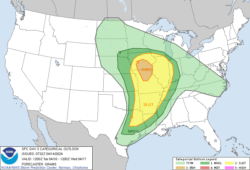
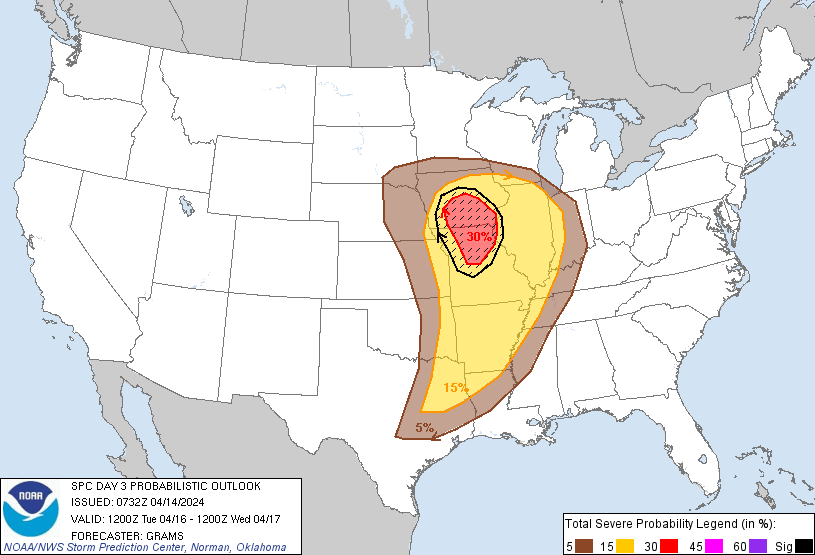
...THERE IS AN ENHANCED RISK OF SEVERE THUNDERSTORMS IN SOUTHERN IA
AND NORTHERN MO...
...SUMMARY...
Scattered severe thunderstorms are likely on Tuesday into Tuesday
night across a portion of the central states from the Corn Belt to
the Ark-La-Tex. The most concentrated corridor of significant severe
hail and tornadoes is forecast over southern Iowa into northern
Missouri from mid-afternoon to early evening.
...Synopsis...
A seasonably deep surface cyclone should be located near the central
KS/NE border area Tuesday morning. This cyclone should gradually
progress east-northeast across the Mid-MO Valley before beginning to
weaken over IA early Wednesday. An initially intense mid-level
jetlet (in excess of 80 kts) should become centered from the Ozark
Plateau into northeast MO by afternoon, before weakening as it
shifts east across the Mid-MS to Lower OH Valleys. The initially
north/south-oriented cold front to the south of the surface cyclone
will progress into the Mid-MS Valley by 12Z Wednesday, with its
trailing portion slowing and then stalling near the Ark-La-Tex.
...Corn Belt/Lower MO and Mid-MS Valleys...
Within the left-exit region of the aforementioned mid-level jet, a
synoptically favorable corridor for mid-afternoon to early evening
supercells is evident. Pronounced boundary-layer heating is expected
west of the Pacific cold front that will effectively function as
more of a dryline. There is moderate uncertainty over the degree of
heating ahead of it, in the wake of early-day convection. But with a
plume of steep mid-level lapse rates attendant to the shortwave
trough overspreading the northwest portion of the surface warm/moist
sector during the afternoon, moderate buoyancy should develop. This
coupled with backed low-level flow and veering of the wind profile
with height should support supercells capable of producing
significant severe hail and tornadoes. How long and far
east-southeast this threat will last into the evening will likely be
modulated by the degree of afternoon boundary-layer heating that can
occur.
...Ark-La-Tex/Mid-South...
Deep-layer shear profiles will be strong and another day of
boundary-layer moistening from the western Gulf should yield a
broadening corridor of severe potential that may linger through much
of the period. As the surface front stalls, it appears that
low-level warm theta-e advection coupled with outflows from
early-day convection will serve as the foci for regenerative storm
development. A mix of all hazards appears possible, with at least a
SLGT-risk worthy tornado threat. Parts of this region may warrant
higher severe probabilities in later outlooks as mesoscale
convective details become more clear.
..Grams.. 04/14/2024
CLICK TO GET WUUS03 PTSDY3 PRODUCT
NOTE: THE NEXT DAY 3 OUTLOOK IS SCHEDULED BY 0730Z