SPC AC 130730
Day 3 Convective Outlook
NWS Storm Prediction Center Norman OK
0230 AM CDT Sat Apr 13 2024
Valid 151200Z - 161200Z
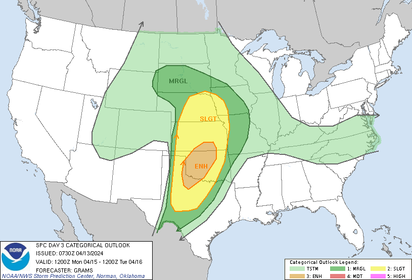
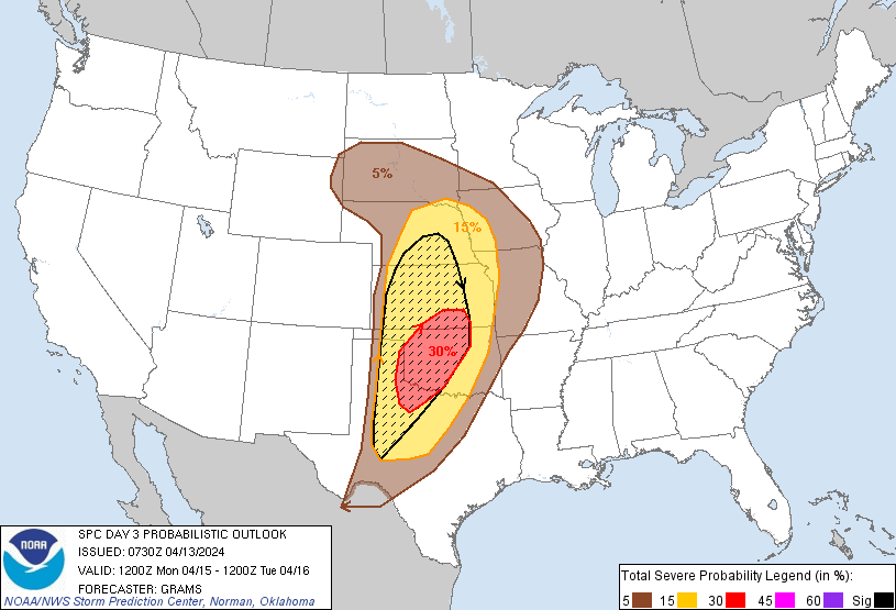
...THERE IS AN ENHANCED RISK OF SEVERE THUNDERSTORMS IN PARTS OF THE
SOUTHERN GREAT PLAINS...
...SUMMARY...
Scattered severe thunderstorms are likely across the southern to
central Great Plains, mainly Monday evening and night. Large to very
large hail, damaging wind gusts, and a few tornadic storms are
possible.
...Central/southern Great Plains...
A shortwave trough should be centered on the southeast Great Basin
at 12Z Monday. Guidance is converging to multiple embedded impulses
ejecting east across the southern Rockies and Southwest, and onto
the central to southern High Plains by early morning Tuesday. This
fragmented evolution and consistently slower timing of ejection onto
the Plains appears less phased with the peak diurnal heating cycle,
suggesting convective development will be later and slightly farther
west than in prior outlook cycles. The southern and more vigorous of
the impulses will still yield substantial tropospheric flow
amplification as an intense mid-level jet evolves across northwest
TX into southern KS Monday night.
Substantial lee cyclogenesis will occur over the central High Plains
Monday afternoon, and drift east along the KS/NE border through 12Z
Tuesday. Low-level moisture modification from the northwest Gulf,
while sufficient for severe storms, will not be overly rich or deep.
Still, there is consensus that a plume of low to mid 60s surface dew
points should be advected ahead of the dryline across much of
western OK into western north TX and the eastern Panhandles. Dryline
initiation in this corridor may be delayed until after 00Z. More
widespread convective development should occur Monday night,
especially as the Pacific cold front overtakes the dryline. The
relatively confined surface-based buoyancy plume and nocturnal MLCIN
with southern/eastern extent suggest initial supercells will
probably consolidate into multiple smaller clusters rather than an
extensive QLCS. Large to very large hail appears to be the
overarching threat given the steep mid-level lapse rates and
supercell wind profiles. The tornado threat will likely be focused
where low-level moisture is relatively greater and discrete
supercell mode can be maintained, seemingly centered around the
northwest TX and western OK vicinity. A swath or two of greater
damaging wind potential may evolve overnight given the amplification
of the flow regime, but will be modulated by weakening instability.
..Grams.. 04/13/2024
CLICK TO GET WUUS03 PTSDY3 PRODUCT
NOTE: THE NEXT DAY 3 OUTLOOK IS SCHEDULED BY 0730Z