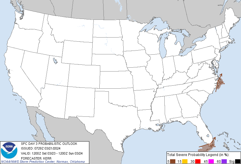
Miami Beach, FL...Kendall, FL...The Hammocks, FL...Kendale Lakes, FL...North Miami, FL...
Probabilistic Graphic
Probability of severe weather within 25 miles of a point. Hatched Area: 10% or greater probability of significant severe within 25 miles of a point.
Day 3 Prob. Risk
Area (sq. mi.)
Area Pop.
Some Larger Population Centers in Risk Area
5 %
8,820
1,801,409
Miami Beach, FL...Kendall, FL...The Hammocks, FL...Kendale Lakes, FL...Coral Gables, FL...
SPC AC 210729
Day 3 Convective Outlook
NWS Storm Prediction Center Norman OK
0229 AM CDT Thu Mar 21 2024
Valid 231200Z - 241200Z
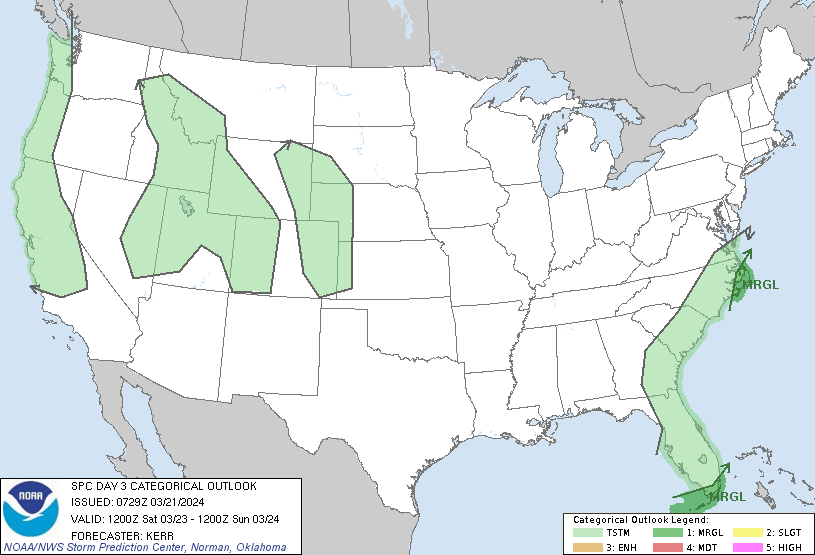
...THERE IS A MARGINAL RISK OF SEVERE THUNDERSTORMS EARLY SATURDAY
ACROSS PARTS OF SOUTHERN FLORIDA AND PARTS OF COASTAL NORTH
CAROLINA...
...SUMMARY...
Strong thunderstorms posing at least some risk for severe weather
may approach or perhaps spread inland across the Outer Banks
vicinity of North Carolina early Saturday, as the risk for strong to
severe thunderstorm development diminishes across parts of southern
Florida.
...Synopsis...
As a more progressive regime continues to spread across the central
into eastern mid-latitude Pacific, blocking initially centered over
the northeastern Pacific is forecast to gradually begin to
breakdown. As this occurs, models suggest that downstream flow may
undergo amplification across the southern mid- and subtropical
latitudes, inland of the Pacific coast into the western Atlantic.
It appears that this will include large-scale mid-level troughing
digging across the Pacific coast through the Southwest, with at
least a couple of significant embedded short wave perturbations.
This will be preceded by building ridging across the Great Plains
into Mississippi Valley, and digging mid-level troughing offshore of
the southern Atlantic Seaboard.
In higher latitudes, a vigorous short wave impulse turning eastward
across the Great Lakes by 12Z Saturday (to the south of an
elongating circulation across southern Hudson Bay into northern
Manitoba) is forecast to accelerate east-northeastward through much
of the St. Lawrence Valley by early Sunday, trailed by a
perturbation emerging from the troughing to the south. Initially
accelerating northeastward to the lee of the southern Appalachians
at the outset of the period, there appears increasing consensus that
this trailing impulse may support a compact deepening surface low,
within elongating surface troughing mostly offshore of the Atlantic
coast. However, there is considerable lingering spread concerning
this and other sub-synoptic developments across and east of the
Atlantic Seaboard.
In the wake of the developing surface low, a significant ongoing
cold intrusion to the lee of the Rockies is forecast to overtake the
offshore surface troughing late Saturday through Saturday night.
Models indicate that the southwestern flank of this cold air will
stall and begin to undergo modification across the lower Mississippi
Valley into central high plains, as surface troughing begins to
deepen to the lee of the Front Range and southern Rockies.
...Florida...
It is possible that an outflow boundary may linger across parts of
the southern peninsula and/or Florida Keys into Saturday morning,
with potential for continuing vigorous thunderstorm development
accompanied by at least some risk for strong, gusty winds. It
appears that this boundary will shift off to the east and south by
midday, if not earlier.
In its wake, models indicate low-level flow quickly veering to an
increasingly westerly component across the remainder of the
peninsula, leading to diminishing convective potential ahead of a
weak approaching cold front.
...Eastern North Carolina...
Severe weather potential appears largely conditional, depending on
the evolution and track of the primary surface low. However, the
inland advection of a moist unstable warm sector appears at least
possible early Saturday, within a strongly sheared environment
across the Outer and Inner Banks vicinity. This may provide a
window of opportunity for organized convective development,
including supercells.
..Kerr.. 03/21/2024
CLICK TO GET WUUS03 PTSDY3 PRODUCT
NOTE: THE NEXT DAY 3 OUTLOOK IS SCHEDULED BY 0730Z