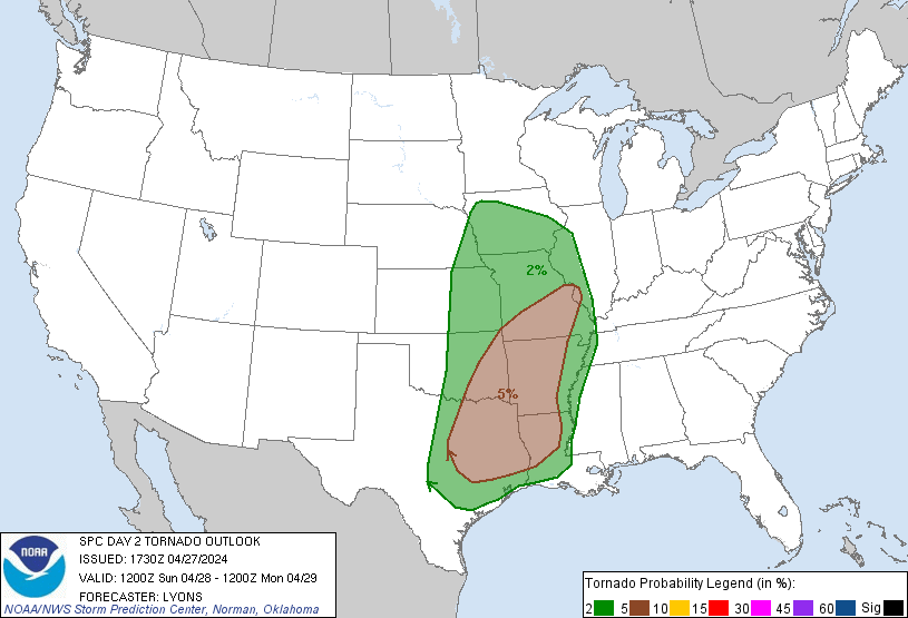
Houston, TX...Austin, TX...Memphis, TN...Oklahoma City, OK...Kansas City, MO...
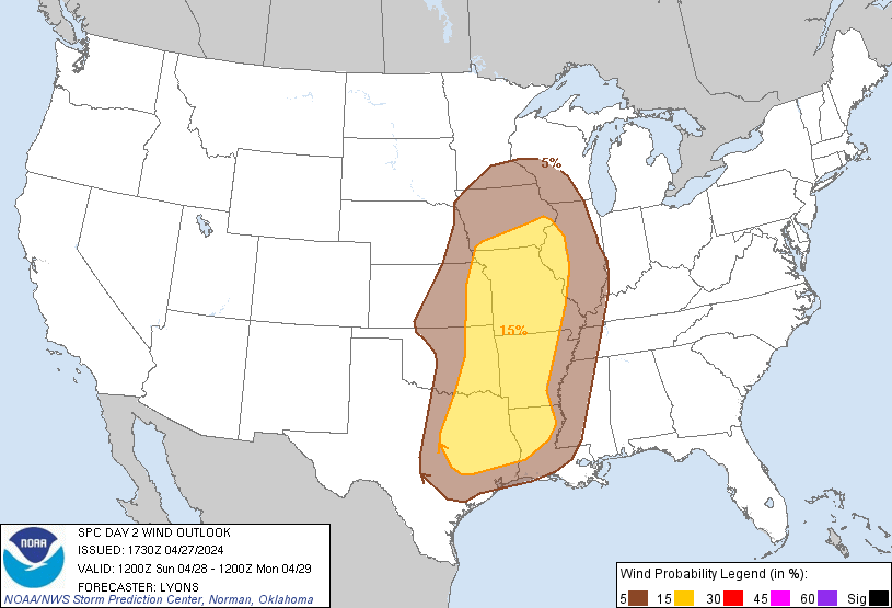
Probabilistic Damaging Wind Graphic
Probability of damaging thunderstorm winds or wind gusts of 50 knots or higher within 25 miles of a point. Hatched Area: 10% of greater probability of wind gusts 65 knots or greater within 25 miles of a point.
Day 2 Wind Risk
Area (sq. mi.)
Area Pop.
Some Larger Population Centers in Risk Area
15 %
243,457
23,172,201
Dallas, TX...Fort Worth, TX...Kansas City, MO...Tulsa, OK...Arlington, TX...
5 %
281,941
27,916,492
Houston, TX...Austin, TX...Memphis, TN...Oklahoma City, OK...Omaha, NE...
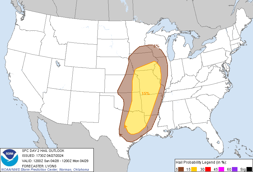
Probabilistic Large Hail Graphic
Probability of hail 1" or larger within 25 miles of a point. Hatched Area: 10% or greater probability of hail 2" or larger within 25 miles of a point.
Day 2 Hail Risk
Area (sq. mi.)
Area Pop.
Some Larger Population Centers in Risk Area
15 %
219,633
22,114,125
Dallas, TX...Fort Worth, TX...Kansas City, MO...Tulsa, OK...Arlington, TX...
5 %
232,659
22,434,374
Houston, TX...Austin, TX...Oklahoma City, OK...Omaha, NE...Wichita, KS...
SPC AC 271730
Day 2 Convective Outlook
NWS Storm Prediction Center Norman OK
1230 PM CDT Sat Apr 27 2024
Valid 281200Z - 291200Z
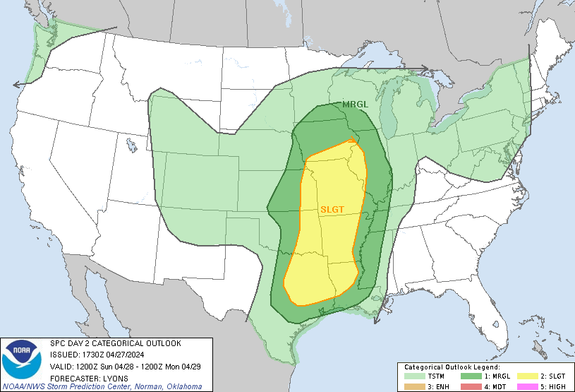
...THERE IS A SLIGHT RISK OF SEVERE THUNDERSTORMS OVER PARTS OF THE
SOUTHERN AND CENTRAL PLAINS INTO THE MISSISSIPPI...
...SUMMARY...
Severe thunderstorms are possible from east Texas into parts of the
upper Mississippi Valley Sunday. Damaging winds, hail, and a few
tornadoes, will all be possible.
...Summary...
A broad, negatively tilted upper trough is forecast to move east
northeastward from the southern/central Plains into the mid MS
Valley and the Midwest Sunday into Sunday night. An attendant
surface low will lift northeast into IA with a dryline trailing
south through eastern NE/KS into central OK. This will serve as a
focus for renewed convective development behind one or more
complicating clusters of ongoing morning storms. Hail, damaging
winds and a few tornadoes are possible.
...East TX into the upper MS Valley...
With broad ascent occurring over an expansive warm sector and mid to
upper 60s F surface dewpoints, one or more clusters of strong to
severe storms are expected to be ongoing early in the period over
the Mississippi Valley into eastern OK/KS and northeast TX. As these
storms continue to move eastward most model guidance shows a general
decrease in severe coverage through the morning hours. However, a
few solutions suggest a line of storms may persist for several hours
with a severe risk across portions of northern AR and southern MO.
With deep meridional shear profiles and limited buoyancy, bands or
clusters of storms capable of isolated damaging winds appear to be
the most likely threat.
Additional redevelopment of more isolated storms is possible ahead
of the dryline across parts of eastern NE/KS, northwest MO and
southern IA closer to the surface low. A few supercells could evolve
with a risk for all hazards. However, confidence in storm evolution
is low with the potential for widespread cloud cover and convection
limiting the extent of the warm sector.
Farther south into northeast TX, eastern OK, and western AR,
redevelopment behind the initial line appears possible from early to
mid afternoon. As the main trough lifts away to the northeast,
low-level warm advection should remain fairly strong and support
weak ascent over much of the warm sector and along the dryline. A
deep and very moist boundary layer with upper 60s to low 70s F
dewpoints will support a broad area of 1500-2000 J/kg of MLCAPE.
However, mid-level lapse rates are expected to remain modest and in
combination with broad/weak ascent and mostly meridional shear
profiles, storms may slowly evolve into clusters and line segments.
Still, strong low-level shear could support storm-scale rotation
with the more semi-discrete convection. Large hail, and a few
tornadoes are possible before storms grow upscale into one or more
linear clusters later in the afternoon into the evening. Damaging
winds and line embedded tornadoes will remain possible as the linear
clusters move eastward into the MS Valley in the evening and through
the overnight hours.
...Upper Midwest/Great Lakes into the Mid Atlantic...
A few stronger storms will be possible Sunday afternoon and evening
from the Great Lakes into northern OH/PA, along the warm front.
Clouds and elevated morning storms are expected to linger through
the day. Instability appears too weak to support an organized severe
threat, though small hail and gusty winds will be possible with a
few stronger storms.
..Lyons.. 04/27/2024
CLICK TO GET WUUS02 PTSDY2 PRODUCT
NOTE: THE NEXT DAY 2 OUTLOOK IS SCHEDULED BY 0600Z