Dallas, TX...Kansas City, MO...Tulsa, OK...Arlington, TX...Plano, TX...
2 %
90,009
8,353,485
Fort Worth, TX...St. Louis, MO...Little Rock, AR...Cedar Rapids, IA...Waco, TX...
Probabilistic Damaging Wind Graphic
Probability of damaging thunderstorm winds or wind gusts of 50 knots or higher within 25 miles of a point. Hatched Area: 10% of greater probability of wind gusts 65 knots or greater within 25 miles of a point.
Day 2 Wind Risk
Area (sq. mi.)
Area Pop.
Some Larger Population Centers in Risk Area
15 %
215,254
19,317,230
Dallas, TX...Fort Worth, TX...Kansas City, MO...Omaha, NE...Tulsa, OK...
5 %
225,944
19,226,792
San Antonio, TX...Austin, TX...Oklahoma City, OK...St. Louis, MO...Madison, WI...
Probabilistic Large Hail Graphic
Probability of hail 1" or larger within 25 miles of a point. Hatched Area: 10% or greater probability of hail 2" or larger within 25 miles of a point.
Day 2 Hail Risk
Area (sq. mi.)
Area Pop.
Some Larger Population Centers in Risk Area
SIG SEVERE
118,954
12,927,299
Dallas, TX...Kansas City, MO...Omaha, NE...Tulsa, OK...Arlington, TX...
30 %
36,207
2,469,322
Omaha, NE...Lincoln, NE...Kansas City, KS...Topeka, KS...Lawrence, KS...
15 %
186,891
17,152,011
Dallas, TX...Fort Worth, TX...Kansas City, MO...Tulsa, OK...Arlington, TX...
5 %
236,368
19,273,702
San Antonio, TX...Austin, TX...Oklahoma City, OK...St. Louis, MO...Madison, WI...
SPC AC 251730
Day 2 Convective Outlook
NWS Storm Prediction Center Norman OK
1230 PM CDT Thu Apr 25 2024
Valid 261200Z - 271200Z
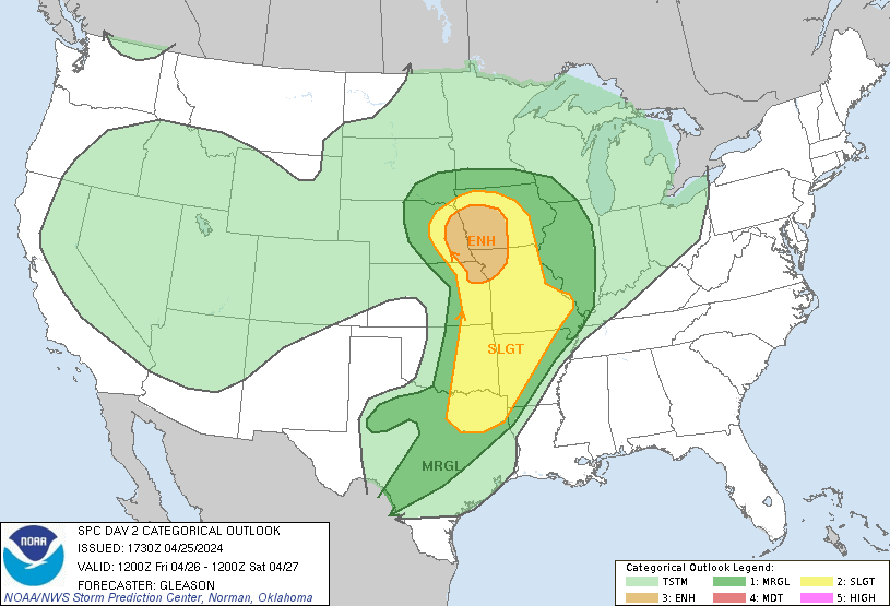
...THERE IS AN ENHANCED RISK OF SEVERE THUNDERSTORMS ACROSS PARTS OF
EASTERN NEBRASKA/NORTHEAST KANSAS INTO NORTHWEST MISSOURI AND
WESTERN/CENTRAL IOWA...
...SUMMARY...
Severe thunderstorms appear likely on Friday from parts of eastern
Nebraska/northeast Kansas into northwest Missouri and Iowa, and
continuing southward into parts of the southern Plains and Ozarks.
Tornadoes (some strong), large to very large hail, and damaging
winds will all be possible.
...Synopsis...
A negatively tilted upper trough over the central Plains Friday
morning will continue to eject northeastward across the Upper
Midwest through the period. A 50-70 kt mid-level jet will accompany
this upper trough, and aid in strong deep-layer shear needed for
thunderstorm organization. A broad southerly low-level jet will be
in place from parts of the southern Plains/Ozarks northward to IA.
Low-level moisture will stream northward from the central Plains
into the parts of the Upper Midwest in response, ahead of a deep
surface low developing northeastward across NE/SD through Friday
evening.
...Eastern Nebraska/Northeast Kansas into Northwest Missouri and
Iowa...
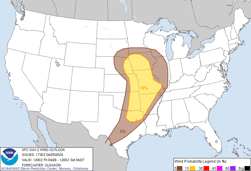
Showers and thunderstorms will likely be ongoing at the start of the
period Friday morning across this region, associated with persistent
lift and the southerly low-level jet. Most of this activity should
tend to remain sub-severe, but isolated hail and gusty winds could
occur. In the wake of this morning convection, a narrow zone of
moderate instability will likely develop across parts of eastern
NE/KS ahead of a surface cold front/dryline. Better forcing
aloft/mid-level height falls associated with the upper trough should
remain on the northern extent of the low-level moisture return and
developing warm sector.
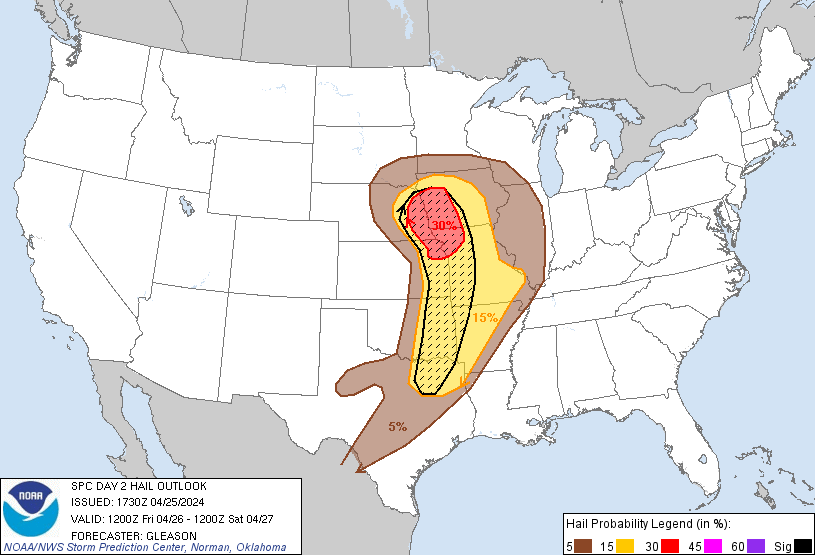
Still, most high-resolution guidance shows robust convective
development by mid Friday afternoon across the eastern NE/northeast
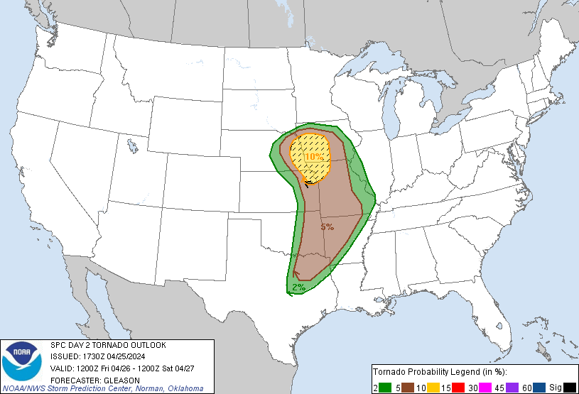
KS vicinity. Strong low-level and deep-layer shear will favor
supercells with attendant threat for tornadoes and very large hail
as these thunderstorms spread into northwest MO and western/central
IA through Friday evening. Given the degree of low-level shear
associated with the 45-55 kt southerly low-level jet, some of these
tornadoes could be strong. The surface warm front draped across
northern/central IA will serve as the northern limit for an
appreciable tornado threat, although some supercells could continue
to pose a threat for large hail even if they become slightly
elevated to the north of the warm front. Based on latest guidance
trends, the Enhanced Risk for tornadoes and large hail has been
adjusted a little northward across eastern NE into IA.
...Southern Plains into the Mid Mississippi Valley/Mid-South...
Initially strong to locally severe thunderstorm clusters are
expected to move across eastern OK/KS and potentially northeast TX
into AR and MO through Friday morning. This activity should pose at
least an isolated severe hail and damaging wind threat before it
eventually weakens. Some of this convection may persist or tend to
regenerate along the eastern periphery of the primary instability
axis, especially across parts of southern MO into AR. The eastern
extent of any severe threat remains uncertain, but favorable
low-level and deep-layer shear could support occasionally organized
convection into the mid MS Valley/Mid-South, with an isolated threat
for large hail, damaging winds, and perhaps a few tornadoes
persisting.
Farther west, moderate to strong instability and strong deep-layer
shear will support a conditionally favorable environment along the
dryline from eastern OK into northeast TX. In the wake of the
departing upper trough to the north, additional development along
the dryline across this region should remain very
isolated/conditional. Even so, any sustained cells would pose a
threat for very large hail and a tornado.
...Northwest Texas...
The dryline will retreat westward across parts of west/northwest TX
late Friday night. Isolated to scattered thunderstorms may form
prior to the end of the period into parts of northwest TX, in
advance of another approaching upper trough over the Southwest.
MUCAPE and deep-layer shear appear sufficient for organized
convection, and isolated large hail may occur with any elevated
thunderstorms that can develop early Saturday morning.
..Gleason.. 04/25/2024
CLICK TO GET WUUS02 PTSDY2 PRODUCT
NOTE: THE NEXT DAY 2 OUTLOOK IS SCHEDULED BY 0600Z