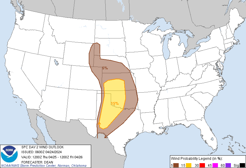
Probability of damaging thunderstorm winds or wind gusts of 50 knots or higher within 25 miles of a point. Hatched Area: 10% of greater probability of wind gusts 65 knots or greater within 25 miles of a point.
Day 2 Wind Risk
Area (sq. mi.)
Area Pop.
Some Larger Population Centers in Risk Area
15 %
125,285
4,097,507
Oklahoma City, OK...Wichita, KS...Lubbock, TX...Abilene, TX...Norman, OK...
SPC AC 240600
Day 2 Convective Outlook
NWS Storm Prediction Center Norman OK
0100 AM CDT Wed Apr 24 2024
Valid 251200Z - 261200Z
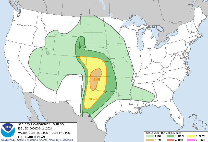
...THERE IS AN ENHANCED RISK OF SEVERE THUNDERSTORMS FROM THE
EASTERN TX PANHANDLE AND WESTERN OK INTO SOUTHWEST/SOUTH-CENTRAL
KS...
...SUMMARY...
Scattered severe thunderstorms are expected from late Thursday
afternoon into Thursday night across parts of the central and
southern Great Plains. Very large hail, severe wind gusts, and a
couple strong tornadoes will all be possible.
...Synopsis...
A shortwave trough initially over the Southwest is still forecast to
take on an increasingly negative tilt as it moves eastward towards
the central/southern Plains by Thursday night into Friday morning.
In response, a deepening surface low will move from the central High
Plains toward northwest KS/southwest NE by late Thursday night into
Friday morning. A surface boundary will move northward as a warm
front across the central Plains through the day, though convective
outflow may limit its progress across parts of central/western KS.
Along/south of the warm front, relatively rich low-level moisture
will stream northward to the east of a dryline that will become
established from the eastern TX Panhandle into western KS and
eastern CO.
...Southern/central Great Plains...
Potential for a few intense supercells remains evident across
western KS into western OK and the OK/TX Panhandles, with a threat
for very large hail, severe wind gusts, and possibly a couple of
strong tornadoes. Isolated supercells will also be possible into
parts of northwest KS, southwest NE, and northeast CO. Some
overnight severe potential also remains evident farther east into
central KS/OK and north TX.
Substantial convection may be ongoing at the start of the period
across parts of eastern KS/OK. While this convection will likely
remain elevated, some threat for hail and isolated damaging gusts
cannot be ruled out through much of the day.This convection may
persist through much of the day, driven by persistent low-level warm
advection to the cool side of the effective outflow. Should this
occur, outflow may tend to spread westward through the day,
providing a limit to the eastward extent of higher-end severe
potential.
Otherwise, a favorable conditional supercell environment is still
expected to develop along/ahead of the dryline from western KS/OK
into the OK/TX Panhandles, as low-level and deep-layer shear
increase across a moderately to strongly unstable environment. While
stronger ascent may not arrive across a broader portion of the
central/southern Great Plains until evening, isolated supercell
development will be possible by late afternoon.
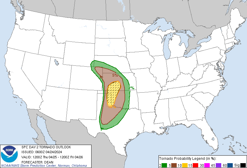
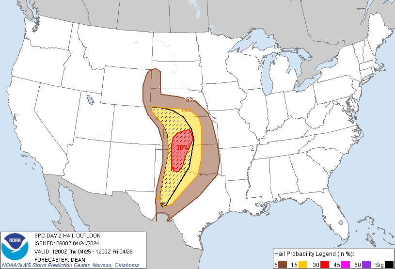
Steep midlevel lapse rates will support an initial threat of very
large hail. The tornado threat will also increase with any supercell
that persists into the evening, with low-level shear/SRH expected to
increase with time and eastward extent, and any longer-lived
supercells could pose a strong tornado threat. Uncertainty remains
regarding the number of supercells that develop, and the longevity
of any such cells into the evening given that outflow may begin
impinging on the warm sector from the east.
Another round of potentially severe storms may develop late Thursday
night into Friday morning along the Pacific front/dryline. Moderate
instability and strong deep-layer shear will support organized
convection with this activity, which may tend to become linear with
time. The overnight storms could pose some threat for all severe
hazards, though the magnitude of the threat remains uncertain due to
lingering near-surface stability and the unfavorable time of day.
...Parts of the central/northern High Plains...
Near/north of the deepening surface, relatively moist low-level
southeasterly flow beneath steep midlevel lapse rates will support
increasing instability through the day. Favorable deep-layer shear
will support isolated supercell potential by mid/late afternoon
across northeast CO and adjacent portions of southwest NE and
northwest KS. Very large hail (potentially 2-2.5 inches in diameter)
will likely be the primary threat, though cells in the vicinity of
the effective warm front will also be capable of producing a tornado
or two.
Farther north, moderate buoyancy will support scattered diurnal
thunderstorm development into the Black Hills vicinity. Deep-layer
shear will be weaker in this area, but may still be sufficient for
modestly organized storms capable of large hail.
..Dean.. 04/24/2024
CLICK TO GET WUUS02 PTSDY2 PRODUCT
NOTE: THE NEXT DAY 2 OUTLOOK IS SCHEDULED BY 1730Z